Ko Mak
| Ko Mak เกาะหมาก | |
|---|---|
| Island | |
 | |
 Island location in Trat Province | |
| Coordinates: 11°49′10″N 102°28′42″E / 11.81944°N 102.47833°ECoordinates: 11°49′10″N 102°28′42″E / 11.81944°N 102.47833°E | |
| Country |
|
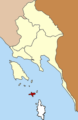
| Province | Trat |
| Seat | Ko Kut |
| Time zone | THA (UTC+7) |
| Postal code | 23000 |
| Geocode | 230504 |
Ko Mak (Thai: เกาะหมาก, pronounced [kɔ̀ʔ màːk]) is a small island of Trat Province, Thailand. The island is named after the Areca nut (หมาก).
History
The first settler on the island was Chao Sua Seng, a Chinese Affairs Officer during the reign of King Rama V, who established a coconut plantation. He then sold the plantation to Luang Prompakdii, also a Chinese Affairs Officer whose descendants still own the land to this day. Luang Prompakdii and his children are known to have established more coconut and rubber plantations, effectively covering most of the arable land in these two sought-after exports.[1]
The first attempt at attracting a tourism market was in 1974, when bungalows were built at Ban Ao Nid on the east of the island. Infrastructure, specifically transport and telecommunications were in their early stages and as a result, the tourism industry on Ko Mak took some time to become established. By 1987 certain beaches and land were cleared and the first resorts were built.[1]
Political history
Originally the area of the Ko Kut district was part of the subdistrict (tambon) Ko Chang, Laem Ngop district. In 1952 the subdistrict Ko Mak was established covering the whole island, at that time subdivided into 4 villages (muban).[2] In 1980 three villages of Ko Mak were split off to create the subdistrict Ko Kut.[3] On 1 April 1990 the government upgraded tambon Ko Kut together with tambon Ko Mak to a minor district (King Amphoe).[4]
Following a decision of the Thai government on 15 May 2007, all of the 81 minor districts were to be upgraded to full districts.[5] With the publishing in the Royal Gazette on 24 August the upgrade became official.[6]
As local government entities the two Tambon administrative organizations (TAO) were created in 2003 and 2004 respectively. The Tambon Council Ko Kut was upgraded to a TAO in 2003,[7] and for Ko Mak in 2004.[8]
Geography
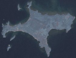
The island of Ko Mak is in the east of the Gulf of Thailand, 35 kilometers from the mainland, and is the third largest island in Trat Province, after Ko Chang and Ko Kut. With an area of 16 square kilometers, Ko Mak has 27 km of coastline, many long sandy beaches, and a few hills.[9] The island is home to approximately 800 locals and renowned for its beautiful beaches, having been included in the UK's Sunday Times 10 most beautiful beaches list in 2006.[10] Ko Mak has a temple, a primary school, 3 fishing villages, a market, and a health center.[1]
It is possible to walk to Ko Kham, a smaller island less than 1 km northwest of Ko Mak during low tide.
Administration
Ko Mak forms part of the Ko Kut District. The district is subdivided into 2 subdistricts (tambon), which are further subdivided into 8 villages (muban). There are 2 Tambon administrative organizations (TAO), one for each subdistrict.[11]
| No. | Name | Thai | Villages | Inh. |
|---|---|---|---|---|
| 1. | Ko Mak | เกาะหมาก | 2 | 403 |
| 2. | Ko Kut | เกาะกูด | 6 | 1,715 |
Tourism
Ko Mak is popular with tourists for its white sandy beaches and clear blue water. The island is small and flat with coconut plantations and mangrove vegetation along the coastline. There are approximately 25 resorts on Ko Mak. Both Ko Kham and Ko Phi can easily be reached with sea kayak or boat rental from the resorts on the northwest coast and are renowned snorkeling destinations.[1]
See also
References
- 1 2 3 4 "kohmak.com". kohmak.com. Retrieved 2014-08-09.
- ↑ ประกาศกระทรวงมหาดไทย เรื่อง ตั้งและเปลี่ยนแปลงเขตตำบลในท้องที่อำเภอแหลมงอบ จังหวัดตราด (PDF). Royal Gazette (in Thai). 69 (43 ง): 2008–2009. 8 July 1952.
- ↑ ประกาศกระทรวงมหาดไทย เรื่อง ตั้งและเปลี่ยนแปลงเขตตำบลในท้องที่อำเภอแหลมงอบ จังหวัดตราด (PDF). Royal Gazette (in Thai). 97 (150 ง): 3391. 30 September 1980.
- ↑ ประกาศกระทรวงมหาดไทย เรื่อง แบ่งเขตท้องที่อำเภอแหลมงอบ จังหวัดตราด ตั้งเป็นกิ่งอำเภอเกาะกูด (PDF). Royal Gazette (in Thai). 109 (25 ง): 1351. 13 February 1990.
- ↑ แถลงผลการประชุม ครม. ประจำวันที่ 15 พ.ค. 2550 (in Thai). Manager Online.
- ↑ พระราชกฤษฎีกาตั้งอำเภอฆ้องชัย...และอำเภอเหล่าเสือโก้ก พ.ศ. ๒๕๕๐ (PDF). Royal Gazette (in Thai). 124 (46 ก): 14–21. 24 August 2007.
- ↑ ประกาศกระทรวงมหาดไทย เรื่อง จัดตั้งองค์การบริหารส่วนตำบล (PDF). Royal Gazette (in Thai). 120 (พิเศษ 146 ง): 20. 22 December 2003.
- ↑ ประกาศกระทรวงมหาดไทย เรื่อง จัดตั้งองค์การบริหารส่วนตำบลเกาะหมาก กิ่งอำเภอเกาะกูด จังหวัดตราด และองค์การบริหารส่วนตำบลวังประจัน อำเภอควนโดน จังหวัดสตูล (PDF). Royal Gazette (in Thai). 121 (พิเศษ 64 ง): 7–8. 9 June 2004.
- ↑ "Ko Mak_Thailand - Hotels - Tours in Thailand - Maps - Thailand Product,OTOP". Thailand.com.co. 2011-12-18. Retrieved 2014-08-09.
- ↑ "Koh Mak: Thailand's Best Kept Secret". Goodtime-resort.com. 2014-06-20. Retrieved 2014-08-09.
- ↑ "Island History". Kohmak.co.uk. Retrieved 2014-08-09.
External links
 Ko Mak travel guide from Wikivoyage