Klickitat Street
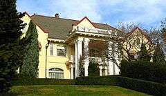 The historic mansion of meatpacking magnate Frank Barnes at number 3533.[1] | |
| Maintained by | City of Portland |
|---|---|
| Length | 3.9 mi[2] (6.3 km) |
| Location | Portland, Oregon |
| West end | Northeast 11th Avenue 45°32′48″N 122°39′18″W / 45.546759°N 122.654874°W |
| East end | Northeast 84th Avenue 45°32′47″N 122°34′36″W / 45.546323°N 122.576776°W |
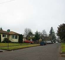
Klickitat Street is a city street located in northeast[3] Portland, Oregon, United States. The main stem of the street is 3.75-mile (6.04 km) long, and runs east-west parallel to—and one block south of—northeast Fremont Street, from its westernmost intersections with North Vancouver Avenue and North Williams Avenue to Northeast 67th Avenue.[4] Additional disconnected segments are east of Rocky Butte from 105th to 117th,[5] 148th to 154th,[6] and 163rd to 165th.[7] A segment named Klickitat Court is between 135th and 140th.[8]
The street is one of Portland's most heavily used bicycle throughways and was selected as one of 15 streets slated for improvement as a "next-generation bicycle boulevard" by the city of Portland.[4] Planned improvements included a flashing beacon at the intersection with NE 33rd, which can be enabled by bicyclists and pedestrians to increase safety and maintain low vehicular traffic.[9]
The street is named after a local Native American tribe, the Klickitat, and was made famous because it is the fictional home of the characters Henry Huggins, Ramona Quimby and Beatrice "Beezus" Quimby in a series of children's novels by Beverly Cleary.[10] Cleary grew up on nearby 37th Street, and said the name reminded her of "the sound of knitting needles."[11] There are statues of the characters in the Beverly Cleary Sculpture Garden in nearby Grant Park.[12]
References
- ↑ Kristine White (Sep 10, 2002), "Living large", The Portland Tribune
- ↑ The Google Maps walking distance is 3.9 miles (6.3 km) according to Google (January 23, 2010). "Klickitat Street" (Map). Google Maps. Google. Retrieved January 23, 2010., but the actual span is 3.75 miles (6.04 km) due to an unknown cause compared to Google Maps straight line measurement tool.
- ↑ Northeast refers to one of Portland's five quadrants. See Neighborhoods of Portland, Oregon for an overview map.
- 1 2 City of Portland Bureau of Transportation. "Bicycle Boulevards / Neighborhood Greenways: Streets with low traffic volume and speed where bicycles, pedestrians and neighbors are given priority". Portland Online. Retrieved January 23, 2011.
- ↑ Maps of 105th to 117th: 45°32′48″N 122°32′54″W / 45.54679°N 122.54833°W
- ↑ Maps of 148th to 154th: 45°32′50″N 122°30′25″W / 45.54714°N 122.50699°W
- ↑ Maps of 163rd to 165th: 45°32′50″N 122°29′37″W / 45.54712°N 122.49354°W
- ↑ Maps of 135th to 140th: 45°32′48″N 122°31′17″W / 45.54653°N 122.52130°W
- ↑ Anne Laufe (May 28, 2010). "Flashing light to aid Alameda's N.E. 33rd crossing". The Oregonian. Retrieved January 22, 2011.
- ↑ Harriet Baskas (2010), Oregon Curiosities, Globe Pequot, pp. 108–110, ISBN 978-0-7627-4971-3
- ↑ Bumiller, Elisabeth (October 26, 1995). "On Klickitat Street With: Beverly Cleary; For 3 Generations, The Child's Choice". The New York Times. Retrieved January 23, 2011.
- ↑ "Beverly Cleary Sculpture Garden". Multnomah County Library. Retrieved June 1, 2010.
Coordinates: 45°32′49″N 122°36′45″W / 45.546942°N 122.612478°W