Kita-Kantō Expressway
| |
|---|---|
| 北関東自動車道 | |
| Route information | |
| Length: | 87.3 km[1] (54.2 mi) |
| Existed: | 2000[2] – present |
| Major junctions | |
| From: |
Takasaki Junction in Takasaki, Gunma |
| To: |
Mito-minani Interchange in Mito, Ibaraki |
| Location | |
| Major cities: | Maebashi, Isesaki, Ōta, Shimotsuke, Utsunomiya, Mooka, Sakuragawa, Kasama |
| Highway system | |
|
National highways of Japan Expressways of Japan | |
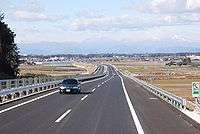
The Kita-Kantō Expressway (北関東自動車道 Kita-Kantō Jidōsha-dō) (lit. North Kantō Expressway) is a 4-laned national expressway in Japan. It is owned and operated by East Nippon Expressway Company.
Overview
The route connects the capitals of the 3 northern prefectures in the Kantō region - Maebashi, Utsunomiya, and Mito.
The expressway begins at a junction with the Kan-etsu Expressway in Gunma Prefecture and heads east along the southern edge of the prefecture. The route ends abruptly in the city of Ōta, however the route will be extended to a junction with the Tōhoku Expressway in Tochigi Prefecture by 2011.[3] The expressway then follows the route of the Tōhoku Expressway northward for about 13 km, then diverges from this expressway following an easterly course once more. It runs through the southern areas of Utsunomiya and heads into eastern areas of Tochigi Prefecture, where the route terminates once again in the city of Mooka. The section connecting Tochigi and Ibaraki Prefectures is scheduled to be completed in 2009.[3] From Sakuragawa in western Ibaraki, the route continues towards a junction with the Jōban Expressway and runs along the southern edge of the Mito city area, where the expressway has its final terminus. At the terminus, the Higashi-Mito Road continues towards the Pacific Ocean coastline using the same roadway.
The route runs parallel to National Route 50 for most of its length.
List of interchanges and features
- IC - interchange, JCT - junction, SA - service area, PA - parking area, BR - bridge
| No. | Name | Connections | Dist. from Origin |
Notes | Location | |
|---|---|---|---|---|---|---|
| 9-1 | Takasaki JCT | 0.0 | Takasaki | Gunma | ||
| BR | Tonegawa Bridge | |||||
| Maebashi | ||||||
| 1 | Maebashi-minami IC | Pref. Route 11 (Maebashi Tamamura Route) | 3.0 | |||
| 2 | Komagawa IC | Pref. Route 2 (Maebashi Tatebayashi Route) | 7.5 | |||
| PA | Hashie PA | 11.7 | Isesaki | |||
| 3 | Isesaki IC | 14.5 | ||||
| 4 | Ōta-Yabuzuka IC | Pref. Route 315 (Ōhara Sakai Mitsugi Route) | 19.9 | Ōta | ||
| PA | Ōta PA | |||||
| 5 | Ōta-Kiryū IC | 30.5 | ||||
| SA | Watarasegawa SA | Ashikaga | Tochigi | |||
| 6 | Ashikaga IC | 40.8 | ||||
| 7 | Sano-Tanuma IC | 49.1 | Sano | |||
| 7-1 | Iwafune JCT | 54.4 | Tochigi | |||
| Concurrent with | ||||||
| (8-1) | Tochigi-Tsuga JCT | 0.0 | Tochigi | Tochigi | ||
| 8 | Tsuga IC | Pref. Route 3 (Utsunomiya Kamewada Tochigi Route) | 3.8 | |||
| PA | Mibu PA | 8.6 | Mibu | |||
| 9 | Mibu IC | Pref. Route 71 (Hanyūda Kamikamou Route) | 10.1 | |||
| 10 | Utsunomiya-Kaminokawa IC | 18.5 | Utsunomiya | |||
| 11 | Mooka IC | 26.0 | Mooka | |||
| 12 | Sakuragawa-Chikusei IC | 40.9 | Sakuragawa | Ibaraki | ||
| 13 | Kasama-nishi IC | Pref. Route 64 (Tsuchiura Kasama Route Bypass) | 49.8 | Kasama | ||
| PA | Kasama PA | 57.5 | ||||
| 14 | Tomobe IC | Pref. Route 16 (Ōarai Tomobe Route) |
58.9 | |||
| (8-2) | Tomobe JCT | 66.3 | ||||
| 15 | Ibarakimachi-nishi IC | Pref. Route 59 (Tamari Mito Route) | 70.4 | Ibaraki | ||
| <15-1> | Ibaraki JCT | Opens in 2009 | ||||
| 16 | Ibarakimachi-higashi IC | 77.2 | ||||
| 17 | Mito-minami IC | 80.6 | Mito | |||
| Through to | ||||||
References
- ↑ "E-NEXCO Expressway Data". Retrieved 2008-04-13.
- ↑ "Ibaraki Prefecture Website". Retrieved 2008-04-15.
- 1 2 "E-NEXCO Opening Schedule". Retrieved 2008-04-15.
External links
| Wikimedia Commons has media related to Kita-Kanto Expressway. |
- (Japanese) East Nippon Expressway Company
- (Japanese) Ibaraki Kitakan (info page by Ibaraki Prefectural Government)
| East Nippon Expressway Company | |
|---|---|
| Central Nippon Expressway Company | |
| West Nippon Expressway Company |
|
| Honshū-Shikoku Bridge Expressway Company |
|
| Urban Expressways | |