Kit's Coty House
 The monument with the Medway Valley behind. | |
 Location within Kent | |
| Coordinates | 51°19′12″N 0°30′10″E / 51.3199°N 0.5029°E |
|---|---|
| Type | Long barrow |
Kit's Coty House or Kit's Coty is the name of the remains of a Neolithic chambered long barrow on Blue Bell Hill near Aylesford in the English county of Kent.
One of the Medway megaliths constructed in the vicinity of the River Medway, Kit's Coty House is located close to five other surviving chambered long barrows: the Coldrum Stones, Addington long barrow, Chestnuts long barrow, the Countless Stones and Coffin Stone.
The site is now under the ownership of non-departmental public body English Heritage, and is open to visitors all year round.
Background
The Early Neolithic was a revolutionary period of British history. Beginning in the fifth millennium BC, it saw a widespread change in lifestyle as the communities living in the British Isles adopted agriculture as their primary form of subsistence, abandoning the hunter-gatherer lifestyle that had characterised the preceding Mesolithic period.[1]
Archaeologists have been unable to prove whether this adoption of farming was because of a new influx of migrants coming in from continental Europe or because the indigenous Mesolithic Britons came to adopt the agricultural practices of continental societies.[1] Between 4500 and 3800 BCE, all of the British Isles came to abandon its former Mesolithic hunter-gatherer lifestyle, to be replaced by the new agricultural subsistence of the Neolithic Age.[2]
There is archaeological evidence of violence and warfare in Early Neolithic Britain from such sites as West Kennet Long Barrow and Hambledon Hill, with some groups constructing fortifications to defend themselves from attackers.[3] Contemporary archaeologists have no direct proof of gender relations on the island at this time, although most believe that it was probably a male-dominated society, in keeping with all recorded societies that practice large-scale animal husbandry.[4]
Megalithic tombs
"It seems that the role of ancestors in Neolithic society was much more important than in the world of the hunter-gatherer. Clans and forebears began to have symbolic importance to the settled farming communities of the Neolithic. Dead ancestors were celebrated through funerals, feasts and grave goods, and their carefully selected body-parts were housed in specially built monuments, often symbolising 'houses' of the dead... The tombs provide the earliest and most tangible evidence of Neolithic people and their customs, and are some of the most impressive and aesthetically distinctive constructions of prehistoric Britain."
Archaeologist and prehistorian Caroline Malone, 2001.[5]
Across Western Europe, the Early Neolithic marked the first period in history when humans began to build monumental structures in the landscape.[4] These monumental structures were tombs designed for holding the remains of the dead, and were sometimes built out of timber, but many were instead constructed out of large stones, known as "megaliths".[4] Individuals were rarely buried alone in the Early Neolithic, instead being interned in collective burials with other members of their community.[5] The construction of these collective burial monumental tombs, sometimes wooden but often megalithic, began in continental Europe before being adopted by people in Britain.[6]
The Early Neolithic people of Britain placed a far greater emphasis on the ritualised burial of the dead than their Mesolithic forebears had done.[5] Many archaeologists have suggested that this is because Early Neolithic people were adherents of an ancestor cult that venerated the spirits of the dead, believing that they could intercede with the forces of nature for the benefit of their living descendants.[5][7] It has furthermore been suggested that Early Neolithic people entered into the tombs – which doubled as temples or shrines – to perform rituals that would honour the dead and ask for their assistance.[7]
The tombs themselves were typically located on prominent hills and slopes overlooking the surrounding landcape, particularly at the junction between different territories.[8] Archaeologist Caroline Malone noted that the tombs would have served as one of a variety of markers in the landscape that conveyed information on "territory, political allegiance, ownership, and ancestors."[9]
Archaeologists have differentiated these Early Neolithic tombs into a variety of different architectural styles, which were typically associated with specific regions within the British Isles.[7] Passage graves, characterised by their narrow passage made of large stones and one or multiple burial chambers covered in earth or stone, were predominantly located in northern Britain and southern and central Ireland. Alternately across northern Ireland and central Britain, long chambered mounds predominated, while in the east and south-east of Britain, earthen long barrows represented the dominant architectural trend.[10] These earthen long barrows were typically constructed of timber because building stone was scarce; archaeologist Aubrey Burl argued that these timber tombs might have been "even more eye-catching" than their stone coutnerparts, perhaps consisting of "towering carved poles, flamboyantly painted", but that evidence of such sculptures has not survived.[7]
Further information
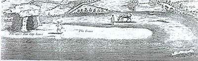
Although badly damaged by ploughing and later vandalism the impressive entrance to the tomb still survives. It consists of three sarsen orthostats supporting a horizontal capstone with a total height of almost 3m. This would have been at one end of a 70m earthern long barrow oriented east-west. A further stone at the site known as the General's Stone or General's Tomb was destroyed in 1867 and may have come from the chamber. William Stukeley visited the site in 1722 and was able to sketch the site whilst it was still largely intact. Before this, Samuel Pepys also saw it and wrote:
Three great stones standing upright and a great round one lying on them, of great bigness, although not so big as those on Salisbury Plain. But certainly it is a thing of great antiquity, and I am mightily glad to see it.
The author George Orwell visited the site on 21 August 1938, as detailed in his domestic diary of that date.[11] He describes it as "..a druidical altar or something of the kind. ..The stones are on top of a high hill & it appears they belong to quite another part of the country." The stones are actually well down the slope of Blue Bell Hill, 1.32 km to the north.[12]


In 1854, it was investigated by Thomas Wright who found 'rude pottery' beneath the stones and further Neolithic sherds were recovered from the surrounding field in 1936.
Trenching in 1956 located the silted-up ditch surrounding the southern side of the monument and further stones which had been pushed into the ditch when the monument was partially demolished. An excavation in advance of High Speed 1, which runs nearby found the remains of a Neolithic longhouse.
In 1885, Kit's Coty was one of the first sites in Britain to become a Scheduled Ancient Monument and the iron railings that surround it were added a few years later at the suggestion of Augustus Pitt Rivers. It is now in the care of English Heritage.
As only the megalithic portion of the barrow was fenced in by the railings, the long earth barrow has been continually ploughed away since, with uncovered stones dumped in woodland nearby by the farmer and the mound itself, still visible in the mid-twentieth century, now gone.
The site is traditionally known as the burial site of Catigern, brother of Vortimer and son of Vortigern following a battle with the Saxon Horsa in the mid fifth century AD - listed in the Anglo-Saxon Chronicle as taking place in 455 AD. In 1947, one of the stones from the kerb was removed.
The Countless Stones, also known as Little Kit's Coty House lie 450m to the south at 51°18'57.64"N 0°30'4.93"E. The name "Kits Coty" allegedly means "Tomb in the Forest" according to signs at the site, possibly related to the Ancient British *kaitom, later *keiton, meaning "forest".
In 1880, the archaeologist Flinders Petrie listed the existence of the stones at Addington in his list of Kentish earthworks.[13] In 1893, the antiquarian George Payne mentioned the monument in his Collectanea Cantiana, describing it as a "fallen cromlech" and noting that there were various other megaliths scattered in the vicinity, suggesting that these were part of the monument of another like it, since destroyed.[14]
Several modern Pagan religions are practised at the Medway Megaliths, the most publicly visible of which is Druidry.[15] Research conducted among these Druids in 2014 revealed that some Druidic ceremonial activity had taken place at Kit's Coty.[15]
References
Footnotes
- 1 2 Hutton 1991. p. 16.
- ↑ Hutton 1991. p. 17.
- ↑ Hutton 1991. pp. 18–19.
- 1 2 3 Hutton 1991. p. 19.
- 1 2 3 4 Malone 2001. p. 103.
- ↑ Malone 2001. pp. 103–104.
- 1 2 3 4 Burl 1981. p. 61.
- ↑ Malone 2001. pp. 106–107.
- ↑ Malone 2001. p. 107.
- ↑ Burl 1981. pp. 61–62.
- ↑ George Orwell Diaries. W.W. Norton & Co. 2012. p. 85. ISBN 978-0-87140-410-7.
- ↑ Google Earth 51.3199°N 0.5029°E
- ↑ Petrie 1880, p. 14.
- ↑ Payne 1893, pp. 126–127.
- 1 2 Doyle White 2016, p. 351.
Bibliography
- "Coldrum Stones". The National Trust. Retrieved 27 August 2012.
- Ashbee, Paul (1998). "Coldrum Revisited and Reviewed". Archaeologia Cantiana. Kent Archaeological Society. 118: 1–44.
- Bennett, F.J. (January–June 1913). "Coldrum Monument and Exploration 1910". Journal of the Royal Anthropological Institute. 43: 76–85. JSTOR 2843160.
- Burl, Aubrey (1981). Rites of the Gods. London: Weidenfeld & Nicolson. ISBN 978-0460043137.
- Clinch, George (1904). "Coldrum, Kent, and Its Relation to Stonehenge". Man. 4: 20–23. JSTOR 2840863.
- Filkins, E. (1928). "Excavations at Coldrum, Kent". The Antiquaries Journal. 8: 356–357. doi:10.1017/s0003581500092970.
- Grinsell, Leslie V. (1976). Folklore of Prehistoric Sites in Britain. London: David & Charles. ISBN 0-7153-7241-6.
- Hutton, Ronald (1991). The Pagan Religions of the Ancient British Isles: Their Nature and Legacy. Oxford, U.K. and Cambridge, U.S.: Blackwell. ISBN 978-0-631-17288-8.
- Keith, A. (January–June 1913). "Report on the Human Remains Found by F. J. Bennett, Esq., F.G.S., in the Central Chamber of a Megalithic Monument at Coldrum, Kent". Journal of the Royal Anthropological Institute. 43: 86–100. JSTOR 2843161.
- Lewis, A.L. (1878). "On a Rude Stone Monument in Kent". The Journal of the Anthropological Institute of Great Britain and Ireland. 7: 140–142. JSTOR 2841379.
- Lewis, A.L. (1904). "The Coldrum Monument". Man. Royal Anthropological Institute of Great Britain and Ireland. 4: 395. JSTOR 2839987.
- Malone, Caroline (2001). Neolithic Britain and Ireland. Stroud, Gloucestershire: Tempus. ISBN 0-7524-1442-9.
- Payne, George (1893). Collectanea Cantiana: Or, Archæological Researches in the Neighbourhood of Sittingbourne, and Otherparts of Kent. London: Mitchell and Hughes.
- Petrie, W.M. Flinders (1880). "Notes on Kentish Earthworks". Archaeologia Cantiana. 13: 8–16.
- Philp, Brian; Dutto, Mike (2005). The Medway Megaliths (third ed.). Kent: Kent Archaeological Trust.
- Smith, Martin; Brickley, Megan (2009). People of the Long Barrows: Life, Death and Burial in the Early Neolithic. Stroud: The History Press. ISBN 978-0752447339.
- Wright (1844). "Proceedings of the Committee". The Archaeological Journal. 1: 262–264.
External links
| Wikimedia Commons has media related to Kit's Coty House. |
- Photo and location map
- Pictures and personal experiences of Kit's Coty House at The Modern Antiquarian
- The tomb's association with Catigern
- Further research and history: English Heritage
Coordinates: 51°19′12″N 0°30′11″E / 51.31990°N 0.50304°E