Kırşehir
| Kırşehir | |
|---|---|
| Municipality | |
 Kırşehir | |
| Coordinates: TR 39°08′44″N 34°09′39″E / 39.14556°N 34.16083°ECoordinates: TR 39°08′44″N 34°09′39″E / 39.14556°N 34.16083°E | |
| Country | Turkey |
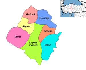
| Province | Kırşehir |
| Government | |
| • Mayor | Yaşar Bahçeci (AKP) |
| Area[1] | |
| • District | 1,677.67 km2 (647.75 sq mi) |
| Population (2012)[2] | |
| • Urban | 114,244 |
| • District | 128,806 |
| • District density | 77/km2 (200/sq mi) |
| Website |
www |
Kırşehir, formerly Macissus (also spelled Mocissus and Mokissos, Μωκισσός in Greek) and Justinianopolis, is a city in Turkey. It is the capital district of the Kırşehir Province. According to the 2000 census, the population of the district is 121,947 of which 105,826 live in the city of Kırşehir.[3][4]
History
The history of Kırşehir dates back to the Hittites. During the period of the Hittites, the basin of Kırşehir was known as the country of "Ahiyuva". This basin also took the name Cappadocia at the time of the Romans and Byzantines.
Kırşehir was once known as Parnassos or Mokissos for the Greeks. The Romans called the city Macis, and after the city was rebuilt by the Byzantine Emperor Justinian (527-565), it was renamed Justinianopolis. This name was retained until the end of Byzantine rule. The Turks took the city in 1071 and bestowed the current name. In Turkish, "Kır Şehri" means "steppe city" or "prairie city". It became the chief town of a sanjak in the Ottoman vilayet of Angora, which possessed 8000 inhabitants, most of them Muslims.
In the 19th century, Kırşehir was attached to the sanjak of Ankara. In the year 1921, Kırşehir was made capital of its own province. Kemal Atatürk visited the city in 1921 and 1931.
Kesikköprü Bridge
Kesikköprü is one of the bridges built by Seljuk Empire in Middle Anatolia. It is on the way of Kırşehir-Konya, about 20 km (12.43 mi) to the south of Kırşehir, and across the River Kızılırmak with its 13 parts.
In the inscription of bridge, it is written that the bridge was built by Atabeg İzzü’d-Din Muhammed in 646 of the Hegira/1248 of the Christian era during the rule of Keykavus, the son of Keyhüsrev.
The ones who came from İzmir and tried to reach Sivas and Erzurum from Tokat passed over Kesikköprü. We have learned that the inscription was sunken into the river in 1953. In the 17th and 18th centuries, it took the name of Kesikköprü due to the fact that caravan roads were invaded by the highwaymen.
The three-line instruction destroyed on stone base can hardly be read.
The inscription
Ressame bi imaret hazihil el kantara el mübareke (fi eyyam han) devlet es sultan el azam İzzü-d dünya ve ‘d Din Ebul Feth Keykavus bin Keyhüsrev Burhan Emirel mü’münin.
El Mevla el sahibul azam atabek el muazzam nazım mesalih il alem nasır el enam zübdetil eyyam izzeddin ebul meli Muhammed zahir Ali Selçuk ve emiril mü’minil azzellahu nasrahu ve ala kadrehu fi şuhuri sene sitte ve arbain ve sitte mie hamiden lillah ve musallian ala nebiihi Muhammed ve alihi vesellem teslimen kesiran.
Ecclesiastical history
Metropolitan Archbishopric of Mocissus
Mocissus was also a Christian bishopric, and became a metropolitan see when, as Procopius (De ædif., V, iv) informs us, Justinian divided Cappadocia into three provinces and made this fortified site in north-western Cappadocia metropolis of Cappadocia Tertia, giving it the name of Justinianopolis. Nothing else is known of its history, and its name should perhaps be written Mocessus. There is no doubt that the site of Mocissus, or Mocessus, is that which is occupied by the modern city of Kırşehir. It figured in the Notitiæ episcopatuum until the 12th or 13th century.
Only a few of its bishops are known: the earliest, Peter, attended the Fifth Ecumenical Council (Second Council of Constantinople, 536); the last, whose name is not known, was a Catholic, and was consecrated after the mid-15th century Catholic Council of Florence by Patriarch Metrophanes II of Constantinople.
Titular see
The diocese was restored in 1895 as a titular archbishopric of the highest (Metropolitan) rank. It's vacant, having had the following incumbents:
- John Joseph Frederick Otto Zardetti (1895.05.25 – 1902.05.09)
- Giacomo Merizzi (1902.08.21 – 1916.03.22)
- Giovanni Battista Vinati (1916.07.31 – 1917.01.09)
- Adolf Fritzen (1919.07.31 – 1919.09.07)
- Lorenzo Schioppa (1920.08.20 – 1935.04.23)
- John Hugh MacDonald (1936.12.16 – 1938.03.05)
- Nicolas Cadi (1939.11.16 – 1941)
- Roger-Henri-Marie Beaussart (1943.12.10 – 1952.02.29)
- Vigilio Federico Dalla Zuanna, O.F.M. Cap. (1952.11.24 – 1956.03.04)
- Giovanni Iacono (1956.10.02 – 1957.05.26)
- Heinrich Wienken (1957.08.19 – 1961.01.21)
- Gabrijel Bukatko (1961.03.02 – 1964.03.24)
Climate
Kırşehir has a hot summer continental climate (Köppen climate classification Dsa), with cold and snowy winters and hot and dry summers. Rainfall occurs mostly during the spring and autumn.
| Climate data for Kırşehir (1960-2012) | |||||||||||||
|---|---|---|---|---|---|---|---|---|---|---|---|---|---|
| Month | Jan | Feb | Mar | Apr | May | Jun | Jul | Aug | Sep | Oct | Nov | Dec | Year |
| Record high °C (°F) | 17.2 (63) |
19.2 (66.6) |
27.3 (81.1) |
30.9 (87.6) |
31.9 (89.4) |
35.6 (96.1) |
40.2 (104.4) |
39.8 (103.6) |
36.2 (97.2) |
32.8 (91) |
23.6 (74.5) |
19.5 (67.1) |
40.2 (104.4) |
| Average high °C (°F) | 4.4 (39.9) |
6.2 (43.2) |
11.3 (52.3) |
16.8 (62.2) |
21.6 (70.9) |
26.0 (78.8) |
29.6 (85.3) |
29.7 (85.5) |
25.7 (78.3) |
19.7 (67.5) |
12.6 (54.7) |
6.7 (44.1) |
17.52 (63.56) |
| Daily mean °C (°F) | −0.2 (31.6) |
1.1 (34) |
5.4 (41.7) |
10.6 (51.1) |
15.3 (59.5) |
19.6 (67.3) |
23.1 (73.6) |
22.8 (73) |
18.2 (64.8) |
12.4 (54.3) |
6.2 (43.2) |
2.0 (35.6) |
11.38 (52.48) |
| Average low °C (°F) | −4.2 (24.4) |
−3.3 (26.1) |
0.2 (32.4) |
4.7 (40.5) |
8.7 (47.7) |
12.5 (54.5) |
15.8 (60.4) |
15.6 (60.1) |
11.1 (52) |
6.4 (43.5) |
1.2 (34.2) |
−1.7 (28.9) |
5.58 (42.06) |
| Record low °C (°F) | −22.6 (−8.7) |
−24.6 (−12.3) |
−21.8 (−7.2) |
−8.2 (17.2) |
−1.4 (29.5) |
2.6 (36.7) |
6.4 (43.5) |
5.9 (42.6) |
1.8 (35.2) |
−6.6 (20.1) |
−14.8 (5.4) |
−22.0 (−7.6) |
−24.6 (−12.3) |
| Average precipitation mm (inches) | 44.4 (1.748) |
35.3 (1.39) |
36.6 (1.441) |
46.5 (1.831) |
44.7 (1.76) |
35.1 (1.382) |
6.8 (0.268) |
5.1 (0.201) |
12.1 (0.476) |
29.7 (1.169) |
38.6 (1.52) |
49.5 (1.949) |
384.4 (15.135) |
| Average rainy days | 12.0 | 10.7 | 10.8 | 11.9 | 11.8 | 7.2 | 3.1 | 2.1 | 3.7 | 7.2 | 9.3 | 12.3 | 102.1 |
| Mean monthly sunshine hours | 93 | 114.8 | 170.5 | 198 | 269.7 | 324 | 368.9 | 353.4 | 288 | 217 | 153 | 96.1 | 2,646.4 |
| Source: Devlet Meteoroloji İşleri Genel Müdürlüğü [5] | |||||||||||||
Famous people from Kırşehir
- Uğur Mumcu, investigative journalist
- Haşim Kılıç, the President of the Constitutional Court of Turkey from October 22, 2007 until February 10th, 2015
- Mustafa Bumin the President of the Constitutional Court of Turkey from May 31, 2000 until June 26th, 2005
- Lütfi Müfit Özdeş, politician
- Osman Bölükbaşı, politician
- Deniz Bölükbaşı, politician
- Nezaket Ekici, artist
- Muharrem Ertaş, folk musician
- Neşet Ertaş, folk poet
- Ahi Evren, preacher - died in Kırşehir
- Caca Bey, politician
- Asik Pasa, preacher, Turkish poet
- Silahdar Seyyid Mehmed Pasha 18th century Ottoman Grand Vizier
Gallery
 Ahi Evran Tomb
 Ahi Evran Tomb entry
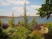 Cügün (Cogun) lake
 Caca Bey (pronounced Jaja) mosque and madrasa
 The ruins of the Üçayak Byzantine Church
Notes
- ↑ "Area of regions (including lakes), km²". Regional Statistics Database. Turkish Statistical Institute. 2002. Retrieved 2013-03-05.
- ↑ "Population of province/district centers and towns/villages by districts - 2012". Address Based Population Registration System (ABPRS) Database. Turkish Statistical Institute. Retrieved 2013-02-27.
- ↑ Turkish Statistical Institute. "Census 2000, Key statistics for urban areas of Turkey" (XLS) (in Turkish). Retrieved 2008-03-19.
- ↑ GeoHive. "Statistical information on Turkey's administrative units". Retrieved 2008-03-19.
- ↑ http://www.dmi.gov.tr/veridegerlendirme/il-ve-ilceler-istatistik.aspx?m=KIRSEHIR
References
- Falling Rain Genomics, Inc. "Geographical information on Kırşehir, Turkey". Retrieved 2008-03-18.
-
 This article incorporates text from a publication now in the public domain: Herbermann, Charles, ed. (1913). "article name needed". Catholic Encyclopedia. New York: Robert Appleton. web link
- District governor's official website (English)
External links
- GigaCatholic with titular incumbent biography links
- District governor's official website (Turkish)
- District municipality's official website (Turkish)
- Kirsehir Portal (Turkish)