Kirkuk Citadel
| Kirkuk citadel | |
|---|---|
| Kurdish: Qelay Kerkûk, Arabic: قلعة كركوك Qal’at Karkuk | |
| Kirkuk, Iraq | |
|
Aerial view of the Kirkuk citadel | |
| Site information | |
| Open to the public | Yes |
| Condition | Partially ruined |
| Official name | Kirkuk Citadel |
| Type | Cultural |
| Criteria | iv |
| State Party | Iraq |
| Region | Middle East |
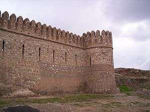
The Kirkuk Citadel (Kurdish: Qelay Kerkûk, Arabic: قلعة كركوك Qal’at Karkuk, Turkish: Kerkük Kalesi) is located in the centre of the city of Kirkuk in Iraq, and is considered to be the oldest part of the city. The citadel stands on an artificial mound 130 feet high located on a plateau across the Khasa River. The mound, or tell, is believed to have been built by King Ashurnasirpal II between 884 and 858 BCE as a military defence line of Arrapha.
Later King Sluks[1] built a strong rampart with 72 towers around the 72 streets and the two entries to the citadel. A jewel of the citadel is the so-called "Red Church", with traces of pre-Muslim mosaics. It is believed that Timur visited the citadel in 1393 during his military expedition. The modern walls go back to the Ottoman period.
In the 1990s, Saddam Hussein, the former Iraqi president, announced a campaign to beautify the walled citadel. Some believe that the campaign's intention was to remove the 800 - 900 mostly Iraqi Turkmen families living in its ancient houses.
The citadel is considered by Turkmen as an important factor in their history. There are several Turkmen neighbourhoods within and around the citadel, such as Topkapi, Helvacilar, Hamam, Agalik, Yedi Kizlar, and Zindan. A large number of historical and religious sites still exist there, such as a tomb that is believed to be the prophet Daniel's Tomb.[2]
See also
References
- ↑ Clifford Edmund Bosworth. The Encyclopaedia of Islam. p. 144.
- ↑ http://www.koord.com/webbook/book/aras/aras1/kerkuk.htm
Coordinates: 35°28′11″N 44°23′45″E / 35.46972°N 44.39583°E