Kips Bay, Manhattan
Coordinates: 40°44′29″N 73°58′42″W / 40.74139°N 73.97833°W
Kips Bay is a neighborhood in the New York City borough of Manhattan. A part of Manhattan Community Board 6, Kips Bay is bordered on the north by Murray Hill; on the west by Madison Square, NoMad, or Rose Hill; on the south by the Gramercy Park neighborhood and the Peter Cooper Village apartment complex; and on the east by the East River. The New York Times defines the boundaries as the area between East 23rd Street to the south, East 34th Street to the north, Lexington Avenue to the west, and the East River to the east.[1] The American Institute of Architects' AIA Guide to New York City considers the western boundary to be Second Avenue.[2]
History
Colonial settlement
Kips Bay was an inlet of the East River running from what is now 32nd Street to 37th Street. The bay extended into Manhattan Island to just west of what is now First Avenue and had two streams that ran from it. The bay was named after New Netherland Dutch settler Jacobus Hendrickson Kip (1631–1690), son of Hendrick Hendricksen Kip, whose farm ran north of present-day 30th Street along the East River.[3] The bay became reclaimed land, yet "Kips Bay" remains the name of the area. Kip built a large brick and stone house, near the modern intersection of Second Avenue and East 35th Street. The house stood from 1655 to 1851, expanded more than once,[4] and when it was demolished was the last farmhouse from New Amsterdam remaining in Manhattan.[5] Iron figures fixed into the gable-end brickwork commemorated the year of its first construction.[3] Its orchard was famous, and, when George Washington was presented with a slip of its Rosa gallica during his first administration, it was claimed to have been the first garden to have grown it in the colonies.[6]
Kips Bay was the site of the Landing at Kip's Bay, an episode of the American Revolutionary War and part of the New York and New Jersey campaign. About 4,000 British Army troops under General William Howe landed at Kips Bay on September 15, 1776, near what is now the foot of East 33rd Street. Howe's forces defeated about 500 American militiamen commanded by Colonel William Douglas. The American forces immediately retreated, and the British occupied New York City soon afterward.[7]
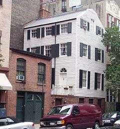
A single survivor of the late 18th or early 19th century in the neighborhood is the simple vernacular white clapboard house, much rebuilt, at 203 East 29th Street. The house, standing gable-end to the street, is one of a mere handful of wooden houses that remain on Manhattan Island. Its date of construction is unknown[8] but has been variously dated from around 1790[9] to as late as 1870;[2] currently listed on the National Register of Historic Places, the house is privately owned and not open to the public.
South of the Kips Bay Farm stood the substantial Federal-style villa erected facing the East River by Henry A. Coster,[10] in the thirty-acre estate[11] that was purchased in 1835 by Anson Greene Phelps;[12] towards the city, the Bull's Head cattle market fronting the Boston Post Road extended southwards from 27th Street to 23rd Street, affording a distinctly less rural aspect;[13] the villa was removed to make way for row houses in the 1860s and the cattle market was moved farther out of town, to 42nd Street.[14]
Later development
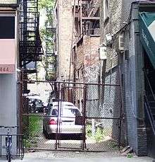
The neighborhood has been rebuilt in patches, so one can see both new high-rise structures often set back from the street, and a multitude of exposed party walls that were never meant to be seen in public. Nearly forgotten feature is the private alley called Broadway Alley, between 26th and 27th Streets, halfway between Lexington and Third Avenues, reputedly the last unpaved street in Manhattan;[16][17] it is not known what this alley is named after, since it is not near the main Broadway.[15]
In the 1960s and later, four Henry Phipps high-rise apartment complexes were constructed mainly on East 29th Street between First and Second Avenues, and south to East 27th Street. Historically, Phipps had been a partner of Andrew Carnegie. Much earlier in time, by 1940, the Madison Square Boys (and later Girls) Club, which had been located on East 30th Street just east of Second Avenue, built its own facilities on East 29th Street (back-to-back with its older facility). In the 1990s, the Club sold its facility to the Churchill School and Center, and since the sale, the Club has operated its office in the Empire State Building.[18][19]
There are two large apartment buildings in the neighborhood named Kips Bay Towers, which are part of a 1,112-unit complex completed in 1963 and designed by architect I.M. Pei.[1]
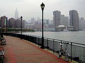
Built on a pier above the East River between East 25th and East 28th Streets is Waterside Plaza, which includes residential towers and the United Nations International School. There were plans to build additional above-water apartments, offices, and a hotel in the 1980s, but environmental concerns and community opposition doomed the project.[20] Today, the waterfront south of Waterside Plaza is Stuyvesant Cove Park. The park includes a small man-made land mass extending out into the East River, which was created from excess cement dumped into the river.[21]
Structures
Within Kips Bay, the area along First Avenue is dominated by the institutional buildings of New York University, including Tisch Hospital, NYU College of Dentistry, NYU School of Medicine, Rusk Institute of Rehabilitation Medicine, Bellevue Hospital Center teaching hospital, including the Hunter College Brookdale Health Sciences Center, the Alexandria Center for the Life Sciences, and the Manhattan VA Hospital. Further north on First Avenue, in Murray Hill between East 37th and East 38th Streets, is the former Kips Bay Brewing Company, originally constructed in 1895 and now occupied by offices.[22]
Many businesses in the neighborhood use the neighborhood's name: e.g. Kips Bay Cinemas, Kips Bay Cleaners, Kips Bay Endoscopy Center and the Kips Bay branch of the New York Public Library.
Since 1965,[23] the area has had a commercial strip mall on Second Avenue between East 30th and 32nd Streets, set back from the street by a driveway running parallel to Second Avenue. This group of stores is referred to as "Kips Bay Plaza" and consists of an AMC/Loews movie theater, a Staples office supply store, a TD Bank, N.A., a Crunch Fitness center, a 24-hour Rite Aid pharmacy and a 44,000 sq ft (4,100 m2) Fairway Market located below ground.[24]
Transportation
There is no New York City Subway service in the area. New York City Bus routes include the M9, M15, M15 SBS, M23 SBS, and M34A SBS.[25]
Kips Bay is expected to be served by the Citywide Ferry Service[26] starting in 2018.[27][28]
Gallery
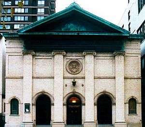 The now-demolished Church of the Sacred Hearts of Mary and Jesus (1915)
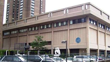
 Three of the four towers of Waterside Plaza on the East River, with UNIS in the right foreground
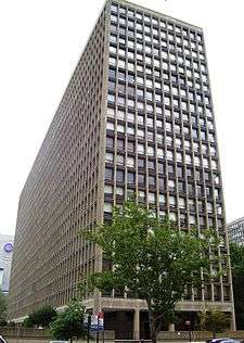
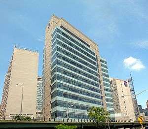 The Smilow Research Building of New York University Medical Center
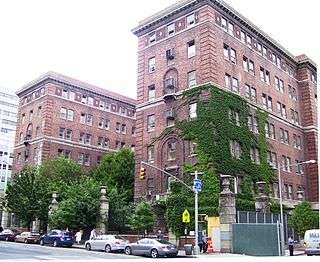 The original Bellevue Psychiatric Hospital building, now a homeless shelter
References
- 1 2 Cohen, Joyce (April 11, 1999). "If You're Thinking of Living In Kips Bay". The New York Times. Retrieved October 15, 2009.
- 1 2 3 White, Norval & Willensky, Elliot (2000), AIA Guide to New York City (4th ed.), New York: Three Rivers Press, ISBN 978-0-8129-3107-5
- 1 2 Post, John J. (1894). Abstract of Title of Kip's Bay Farm in the city of New York: with all known maps relating thereto, together with the water grants on the East River adjoining said farm, and releases from the city on the Eastern Post Road... also, the early history of the Kip family. New York: S. Victor Constant.
- ↑ "Early New York - Panorama Of Ancient East River Homes". Old And Sold. Retrieved January 9, 2010.
It was a large double structure, with three windows on one side of the door and two on the other, and with an ample wing besides. It was built of brick imported from Holland, and a stone coat of arms of the Kip family projected over the doorway. It was the oldest house on the island when it was demolished in 1851, and Thirty-fifth Street and Second Avenue now pass over its site and give no sign of its existence and story.
- ↑ http://wyckoffmuseum.org/about/history/
- ↑ "Few Landmarks Around Kip's Bay". The New York Times. November 28, 1913. Retrieved July 12, 2009.
- ↑ Tim Heffernan (April 19, 2005). "Close-Up on Kips Bay". Retrieved May 28, 2015.
- 1 2 Gray, Christopher (April 2, 2006). "A House That's Shy About Revealing Its Age". The New York Times. Retrieved July 20, 2010.
- ↑ Robinson, George (December 7, 2003). "F.Y.I.". The New York Times. Retrieved January 22, 2010.
- ↑ The engraved illustration in Mrs Martha Joanna Lamb and Mrs Burton Harrison, History of the City of New York: its origin, rise and progress, vol. 3 p. 522, though called "more of a Grecian type of architecture", shows characteristic Federal architecture in its balustraded roofline, its half-oval fanlight in the central pediment, and the widely spaced slender columns of the portico; see also Eliza Greatorex drawing (New York Public Library).
- ↑ "Early New York: Panorama of ancient East River homes" 1893.
- ↑ Burrows, Edwin G.; Wallace, Mike (1999). Gotham: A History of New York City to 1898. New York: Oxford University Press. p. 460. ISBN 0-19-514049-4.
- ↑ "After leaving Twenty-seventh Street and Third Avenue the traveller was in the country. There was no other settlement until Yorkville was reached, nearly two miles beyond. Scattered farm-houses, distant villas, green fields, and bits of woodland made up the landscape." recalled the writer of "Old Days In Yorkville and Harlem", 1893, recalling the route up Third Avenue in the 1850s
- ↑ "Early New York - Old Days In Yorkville And Harlem". Old And Sold. Retrieved January 9, 2010.
- 1 2 Moscow, Henry (1978), The Street Book: An Encyclopedia of Manhattan's Street Names and Their Origins, New York: Hagstrom, ISBN 0823212750, p.31
- ↑ Feuer, Alan (November 27, 2005). "On a Manhattan Byway, Feeling Dirt Beneath Feet". The New York Times. Retrieved March 19, 2010.
- ↑ Walsh, Kevin (2006). Forgotten New York: Views of a Lost Metropolis. New York: HarperCollins. p. 167. ISBN 0-06-114502-5.
- ↑ Sutton, Imre (2008). Back to E. 29th Street: Where Fact and Fiction Revisit Kips Bay, N.Y. Fullerton: Americo Publications. hdl:1813/11665.
- ↑ Harris, Irving (2009). Madison Square Memoir: The Magic and History of Madison Square Boys and Girls Club.
- ↑ Stamler, Bernard (October 26, 1997). "Park to Grow on the Ashes of the Riverwalk Plan". The New York Times. Retrieved July 12, 2009.
- ↑ Kinetz, Erika (January 13, 2002). "Rock Outcropping or Rubble? No One's Neutral on Old Cement". The New York Times. Retrieved July 12, 2009.
- ↑ White, Norval & Willensky, Elliot (2000), AIA Guide to New York City (4th ed.), New York: Three Rivers Press, ISBN 978-0-8129-3107-5, p.219
- ↑ Jackson, Kenneth T., ed. (2010), The Encyclopedia of New York City (2nd ed.), New Haven: Yale University Press, ISBN 978-0-300-11465-2
- ↑ Hughes, C.J. (February 9, 2004). "Choosing the Proximity of the Middle". The New York Times. Retrieved July 3, 2009.
- ↑ "Manhattan Bus Map" (PDF). Metropolitan Transportation Authority (New York). 2016. Retrieved 2016-09-23.}
- ↑ DNAinfoNewYork. "Proposed Routes for NYC's Expanded Ferry Service". Scribd. Retrieved September 22, 2016.
- ↑ "Citywide Ferry Service to Launch in June 2017, Official Says". DNAinfo New York. 2016-03-03. Retrieved 2016-09-22.
- ↑ "New York City's Ferry Service Set to Launch in 2017". NBC New York. Retrieved 9 May 2016.
External links
 Media related to Kips Bay, Manhattan at Wikimedia Commons