Kingston, Jamaica
| Kingston | |
|---|---|
| City and Capital | |
| Kingston and St. Andrew Corporation (Greater Kingston) | |
|
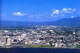
Photo of the city of Kingston taken from a helicopter | |
| Motto: A city which hath foundations[1] | |
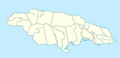 Kingston Location of Kingston shown within Jamaica | |
| Coordinates: 17°59′N 76°48′W / 17.983°N 76.800°WCoordinates: 17°59′N 76°48′W / 17.983°N 76.800°W | |
| Country | Jamaica |
| County | Surrey |
| Parish |
Kingston St. Andrew |
| Established | 1692 |
| Government | |
| • Mayor | Angela Brown-Burke |
| Area | |
| • Total | 480 km2 (190 sq mi) |
| Elevation | 9 m (30 ft) |
| Population (2011) | |
| • Total | 1,041,084 |
| • Density | 1,358/km2 (3,520/sq mi) |
| Time zone | EST (UTC-5) |
Kingston (/ˈkɪŋstən/ or US /ˈkɪŋztən/) is the capital and largest city of Jamaica, located on the southeastern coast of the island. It faces a natural harbour protected by the Palisadoes, a long sand spit which connects the town of Port Royal and the Norman Manley International Airport to the rest of the island. In the Americas, Kingston is the largest predominantly English-speaking city south of the United States.
The local government bodies of the parishes of Kingston and St. Andrew were amalgamated by the Kingston and St. Andrew Corporation Act of 1923, to form the Kingston and St. Andrew Corporation (KSAC). Greater Kingston, or the "Corporate Area" refers to those areas under the KSAC; however, it does not solely refer to Kingston Parish, which only consists of the old downtown and Port Royal. Kingston Parish had a population of 96,052, and St. Andrew parish had a population of 555,828 in 2001.[2] Kingston is only bordered by Saint Andrew to the east, west and north. The geographical border for the parish of Kingston encompasses the following communities, Tivoli Gardens, Denham Town, downtown Kingston, National Heroes Park, Kingston Gardens, Rae Town, Bournemouth Gardens, Norman Gardens, Springfield, Rennock Lodge, Port Royal along with portions of Allman Town, Franklyn Town and Rollington Town.[3][4]
The city proper is bounded by Six Miles to the west, Stony Hill to the north, Papine to the northeast and Harbour View to the east, communities in urban and suburban Saint Andrew. Communities in rural St. Andrew such as Gordon Town, Mavis Bank, Lawrence Tavern, Mt. Airy and Bull Bay would not be described as being in Kingston city.
Two parts make up the central area of Kingston: the historic Downtown, and New Kingston. Both are served by Norman Manley International Airport and also by the smaller and primarily domestic Tinson Pen Aerodrome.
History
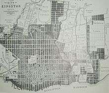
Kingston was founded in July 1692 as a place for survivors of the 1692 earthquake that destroyed Port Royal. Before the earthquake, Kingston’s functions were purely agricultural. The earthquake survivors set up a camp on the sea front. Approximately two thousand people died due to mosquito-borne diseases. Initially the people lived in a tented camp on Colonel Barry's Hog Crawle. The town did not begin to grow until after the further destruction of Port Royal by fire in 1703. Surveyor John Goffe drew up a plan for the town based on a grid bounded by North, East, West and Harbour Streets. The new grid system of the town was designed to facilitate commerce, particularly the system of main thoroughfares 66 feet (20 m) across which allowed transportation between the port and plantations farther inland.[5] By 1716 it had become the largest town and the centre of trade for Jamaica. The government sold land to people with the regulation that they purchase no more than the amount of the land that they owned in Port Royal, and only land on the sea front. Gradually wealthy merchants began to move their residences from above their businesses to the farm lands north on the plains of Liguanea.
The first free school, Wolmers's, was founded in 1729[6] and there was a theatre, first on Harbour Street and then moved in 1774 to North Parade. Both are still in existence. In 1755 the governor, Sir Charles Knowles, had decided to transfer the government offices from Spanish Town to Kingston. It was thought by some to be an unsuitable location for the Assembly in proximity to the moral distractions of Kingston, and the next governor rescinded the Act. However, by 1780 the population of Kingston was 11,000, and the merchants began lobbying for the administrative capital to be transferred from Spanish Town, which was by then eclipsed by the commercial activity in Kingston.
By the end of the 18th century, the city contained more than 3,000 brick buildings. The harbour fostered trade, and played part in several naval wars of the 18th century. Kingston took over the functions of Spanish Town (the capital at the time). These functions included agriculture, commercial, processing and a main transport hub to and from Kingston and other sections of the island.
The government passed an act to transfer the government offices to Kingston from Spanish Town, which occurred in 1872. It kept this status when the island was granted independence in 1962.
.jpg)
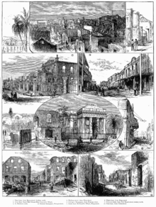
In 1907, 800 people died in another earthquake known as the 1907 Kingston earthquake, destroying nearly all the historical buildings south of Parade in the city. That was when a restriction of no more than 60 feet (18 m) was instituted on buildings in the city centre. These three story high buildings were built with reinforced concrete. Construction on King Street in the city was the first area to breach this building code.
During the 1930s, island-wide riots led to the development of trade unions and political parties to represent workers.
The city became home to the Mona campus of the University of the West Indies founded in 1948, with 24 medical students.
Not until the 1960s did major change occur in the development of Kingston’s city centre. The international attention of reggae music at that time coincided with the expansion and development of 95 acres (38 ha) of the Kingston city centre waterfront area. These developments led to an influx of shops and offices, and the development of a new financial centre: New Kingston, which replaced the Knutsford Racetrack. Multi-story buildings and boulevards were placed within that section.
In 1966 Kingston was the host city to the Commonwealth Games.
The western section of the city was not the focus of development, and that area proved to be politically tense. The 1970s saw deteriorating economic conditions that led to recurrent violence and a decline in tourism which later affected the island.

In the 1980 general elections, the democratic socialist People's National Party (PNP) government was voted out, and subsequent governments have been more market-oriented. Within a global urban era, the 1990s saw that Kingston has made efforts to modernise and develop its city structure and functions. Various organisations such as the Kingston Restoration Company, the Urban Development Corporation (UDC), the Port Authority of Jamaica and the Port Royal Development Company, among others sought to develop the urban structure of the city.
Demographics
The majority of the population of Kingston is of African descent. Large minority ethnic groups include East Indians and Chinese, who came to the country as indentured servants in the late 19th century. The Chinese occupy important roles in Jamaica's economy especially in the retail markets in Downtown Kingston and the wider metropolitan area. There is also a minority of Europeans, mostly descending from immigrants from Germany and Great Britain. Syrians and Lebanese form one of the most influential ethnic groups in not only Kingston, but the entire island. Though a minority ethnic group, the Lebanese were able to give Jamaica one of its prime ministers in the form of Edward Philip George Seaga. There is a strong undercurrent of bias based on skin color as darker skinned Jamaicans are usually at the very bottom of the socio-economic ladder; a phenomenon evidenced by the disproportionate representation of foreigners and mixed-race individuals in lucrative private sector and government positions. Multi-racial Jamaicans continue to form the second largest racial group and, there is also a small Jewish population in the city.[7]
Religion
There is a wide variety of Christian churches in the city. Most are Protestant, a legacy of British colonisation of the island. The chief denominations are Church of God, Baptist, Anglican, Methodist, Roman Catholic, Seventh-day Adventist and Pentecostal. Afro-Christian syncretic religions such as the Rastafari movement also have a significant following.
The Shaare Shalom Synagogue serves Kingston's Jewish population. The city also has communities of Buddhists and Muslims. The Islamic Council of Jamaica and the Islamic Education and Dawah Centre are both located in Kingston. There are three units of the Church of Jesus Christ of Latter-day Saints in the city.[8]
Economy
Kingston plays a central role in Jamaica's economy. The vast majority of economic activity takes place within Kingston, and as most government ministries are located in the city, it is a key force in legislation in regards to Jamaica's finances. The high population density of the capital city means that the majority of monetary transactions occur in Kingston - stimulating much of Jamaica's local economy. Many multinational conglomerates and financial institutions are headquartered in and around the Kingston Metropolitan Area. The Jamaican government has expressed a desire and as such, passed legislation to transform Kingston into an International Financial Centre. This IFC will most likely be located along the Kingston waterfront, and be a part of the wider revitalisation and gentrification programme for Kingston city centre.
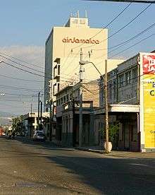
Air Jamaica was headquartered in Kingston.[9]
Geography and climate
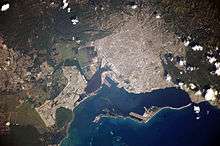
Kingston is surrounded by the Blue Mountains, Red Hills, Long Mountain and the Kingston Harbour. The city is on the Liguanea plain, an alluvial plain alongside the Hope River. Kingston experiences frequent earthquakes, including the 1907 earthquake.
Kingston has a tropical climate, specifically a tropical wet-and-dry climate, characterised by a wet season from May to November, which coincides with the hurricane season, and a dry season from December to April. During the dry season, there is not much rainfall, however, cold and stationary fronts occur at this time, and often bring heavy showers, especially in March. Kingston is in the rain shadow of the Blue Mountains; therefore, little to none of the moisture carried by the Northeast Trade Winds falls over Kingston, causing Kingston to be very dry in comparison to Portland and Saint Mary on the windward side of the Blue Mountains. Kingston is on a coastal location, hence it comes under the influence of the sea, though dense urban development can negate this effect. In the 21st century, Kingston has experienced temperatures as high as 38.8 °C (102 °F) and as low as 13.4 °C (56 °F). Between 1895 and 1990, the total average rainfall was recorded at 813 mm (32.0 in), the highest monthly average rainfall recorded in October at 177 mm (7.0 in), and the lowest monthly average rainfall recorded in March at 18 mm (0.71 in).[10] Snow, fog, hail, thunder and tornadoes are all extremely rare.[11]
| Climate data for Kingston (St. George's College, Jamaica) | |||||||||||||
|---|---|---|---|---|---|---|---|---|---|---|---|---|---|
| Month | Jan | Feb | Mar | Apr | May | Jun | Jul | Aug | Sep | Oct | Nov | Dec | Year |
| Average high °C (°F) | 30.3 (86.5) |
30.2 (86.4) |
30.7 (87.3) |
31.1 (88) |
31.6 (88.9) |
32.1 (89.8) |
32.8 (91) |
32.7 (90.9) |
32.1 (89.8) |
31.7 (89.1) |
31.2 (88.2) |
30.6 (87.1) |
31.4 (88.5) |
| Average low °C (°F) | 21.1 (70) |
21.0 (69.8) |
21.6 (70.9) |
22.6 (72.7) |
23.6 (74.5) |
24.2 (75.6) |
24.3 (75.7) |
24.2 (75.6) |
24.0 (75.2) |
23.4 (74.1) |
22.8 (73) |
21.8 (71.2) |
22.9 (73.2) |
| Average precipitation mm (inches) | 18 (0.71) |
19 (0.75) |
20 (0.79) |
39 (1.54) |
100 (3.94) |
74 (2.91) |
42 (1.65) |
98 (3.86) |
114 (4.49) |
177 (6.97) |
65 (2.56) |
47 (1.85) |
813 (32.01) |
| Average precipitation days | 5 | 5 | 5 | 7 | 8 | 7 | 6 | 9 | 11 | 14 | 10 | 6 | 93 |
| Average relative humidity (%) (at 13:00) | 64 | 64 | 64 | 66 | 68 | 67 | 64 | 66 | 71 | 73 | 69 | 65 | 67 |
| Mean monthly sunshine hours | 257.3 | 240.1 | 260.4 | 258.0 | 254.2 | 237.0 | 260.4 | 257.3 | 213.0 | 223.2 | 222.0 | 235.6 | 2,918.5 |
| Mean daily sunshine hours | 8.3 | 8.5 | 8.4 | 8.6 | 8.2 | 7.9 | 8.4 | 8.3 | 7.1 | 7.2 | 7.4 | 7.6 | 7.99 |
| Source: Meteorological Service (Jamaica)[10] | |||||||||||||
| Climate data for Kingston, Jamaica (Norman Manley International Airport) extremes 1852–present | |||||||||||||
|---|---|---|---|---|---|---|---|---|---|---|---|---|---|
| Month | Jan | Feb | Mar | Apr | May | Jun | Jul | Aug | Sep | Oct | Nov | Dec | Year |
| Record high °C (°F) | 35.1 (95.2) |
34.8 (94.6) |
35.1 (95.2) |
35.7 (96.3) |
35.0 (95) |
36.9 (98.4) |
37.1 (98.8) |
36.1 (97) |
35.8 (96.4) |
35.4 (95.7) |
37.1 (98.8) |
35.0 (95) |
37.1 (98.8) |
| Average high °C (°F) | 29.8 (85.6) |
29.6 (85.3) |
29.8 (85.6) |
30.3 (86.5) |
30.8 (87.4) |
31.2 (88.2) |
31.7 (89.1) |
31.9 (89.4) |
31.7 (89.1) |
31.3 (88.3) |
31.1 (88) |
30.5 (86.9) |
30.8 (87.4) |
| Average low °C (°F) | 22.3 (72.1) |
22.3 (72.1) |
22.9 (73.2) |
22.6 (72.7) |
24.7 (76.5) |
25.3 (77.5) |
25.6 (78.1) |
25.3 (77.5) |
25.3 (77.5) |
24.8 (76.6) |
24.1 (75.4) |
23.1 (73.6) |
24.0 (75.2) |
| Record low °C (°F) | 18.5 (65.3) |
18.0 (64.4) |
18.0 (64.4) |
19.2 (66.6) |
20.0 (68) |
21.0 (69.8) |
20.6 (69.1) |
19.9 (67.8) |
20.0 (68) |
19.0 (66.2) |
19.0 (66.2) |
18.0 (64.4) |
18.0 (64.4) |
| Average precipitation mm (inches) | 18 (0.71) |
16 (0.63) |
14 (0.55) |
27 (1.06) |
100 (3.94) |
83 (3.27) |
40 (1.57) |
81 (3.19) |
107 (4.21) |
167 (6.57) |
61 (2.4) |
31 (1.22) |
745 (29.33) |
| Average precipitation days | 10 | 8 | 7 | 9 | 11 | 7 | 6 | 6 | 9 | 12 | 11 | 9 | 105 |
| Average relative humidity (%) (at 13:00) | 81 | 77 | 76 | 78 | 78 | 75 | 75 | 76 | 78 | 78 | 80 | 81 | 78 |
| Mean monthly sunshine hours | 226.3 | 211.9 | 241.8 | 228.0 | 229.4 | 234.0 | 266.6 | 254.2 | 234.0 | 232.5 | 225.0 | 226.3 | 2,810 |
| Mean daily sunshine hours | 7.3 | 7.5 | 7.8 | 7.6 | 7.4 | 7.8 | 8.6 | 8.2 | 7.8 | 7.5 | 7.5 | 7.3 | 7.69 |
| Source #1: Meteorological Service (Jamaica)[10] | |||||||||||||
| Source #2: Meteo Climat (record highs and lows)[12] | |||||||||||||
Housing
In 1848 the Jamaican government expanded Kingston by constructing new homes in the west, north and east of the city. This housing became highly segregated in terms of race and class and by 1860 the majority of white elites lived on the outskirts of the city. [13]
As Kingston’s population grew, existing settlements became so densely occupied that marshes in the southwest were filled in to allow the development of new housing. By 1935, continued population growth and poverty resulted in the emergence of slums in the east and west of the city. Later these areas were demolished by the government and residents were rehoused in Denham Town. This development accommodated 3,000 people, leaving more than one sixth of displaced resident homeless. Consequently, overcrowding persisted throughout the city and cramped living condition resulted in public health issues. [13]
Suburbanization also became significant and by the 1960s this residential area spread to the foothills of the Blue Mountains. Subsequently, the lack of space and continued consumerism meant this area then expanded to the east of the mountains.[14]
In Kingston, 20% of the population now live in squatter settlements.[15] Contrastingly, Kingston is also home to the ‘Goldilocks zone’, a suburb that holds some of the most expensive houses in all of Jamaica.[16]
Parks
The city of Kingston is home to a number of urban parks which are frequently transformed to accommodate various events and festivities on the Jamaican calendar. The most popular parks include: Emancipation Park, Hope Gardens, Devon House, National Heroes' Park, St William Grant Park and Mandela Park.
Emancipation Park
The Liguanea Club, a recreational and social club for the upper class in society, located on Knutsford Boulevard, owned over 35 acres (14 ha) of land including the former Liguanea Park now the site of Emancipation Park. The Club gave the land measuring seven acres as a gift to the Jamaican Government.
Several government members argued that the land should be converted into a business district, while others felt a multi-functional entertainment complex should be built on the site. The large financial input needed for either venture, was not forthcoming. In 2002 Cabinet granted approval for the transfer of the land to the National Housing Trust on the condition that a park was built and maintained at that location. The land was transferred for one Jamaican dollar.[17]
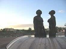
The park is well known for the 11 ft. (approximately 3m) high bronze sculpture done by Jamaican artist Laura Facey-Cooper, situated at the Park's main entrance. This prominent sculpture comprises two naked black male and female statues gazing to the skies – symbolic of their triumphant rise from the horrors of slavery. The statue was unveiled in July 2003, in time for the Park's first anniversary[18] which caused an out cry from the Jamaican populace who believed that the blatant nudity and generous bodily proportions of the figures were very inappropriate to depict the freedom of black people.[19]
Hope Gardens
The Royal Botanical Gardens at Hope, popularly called Hope Gardens serves as a national attraction. The Hope Gardens is a part of the 2,000 acres (809 ha) of land making it the largest botanical garden in the English-speaking Caribbean. The land situated by the foothills of the Blue Mountains was originally owned by Major Richard Hope from whom it got its name. Two hundred acres of this land was obtained by the Government of Jamaica in 1880 and was originally established as a plant introduction and crop-testing facility for plants such as pineapple, cocoa, coffee and tobacco. The formal Botanical Gardens were laid out on approximately 60 acres (24 ha) of this land with the assistance of personnel from the Kew Gardens in England.
In the 1950s, the Queen, after visiting the island and being pleased with the state of the gardens, gave permission for it to be called the Royal Botanical Gardens, Hope. The Gardens have many exotic species along with some endemic trees of Jamaica. Over the years, the ravages of hurricanes and other disasters have resulted in the loss of a significant number of species. However, there are still some prominent trees and popular sites to be viewed in the Gardens. At Hope Gardens, visitors can view a number of other features including the Coconut Museum, the Sunken Gardens, the Orchid House, the Lily Pond, the Maze and Palm Avenue.[20][21]
The Hope Gardens has an adjoining zoo referred to as Hope Gardens Zoo. The gardens and zoo are currently undergoing redevelopment to improve the physical landscape and the animal inventory as a part of Bring Back The Hope campaign.[22]
Transport
Road
The St William Grant Park (Parade) in the heart of downtown Kingston is the starting point for three of Jamaica's four A roads, namely the A1 (Kingston to Lucea), the A3 (Kingston to Saint Ann's Bay) and the A4 (Kingston to Annotto Bay), while the city itself is provided with a dense network of trunk, main, secondary and minor roads. It also consists of the Highway 2000, Jamaica which runs through Portmore, Ocho Rios and Mandeville. A new section of Highway 2000, Jamaica (called "T3") was recently opened to the public. It has greatly reduced the travel time between Kingston and Montego Bay from 4 hours to a mere 2 1/2 hours.
Kingston is served well by a modern bus system, mini buses and taxis, which operate throughout the city with major hubs at Parade, Cross Roads, Half Way Tree and elsewhere.[23]
Private car ownership levels are high, and like many major urban conurbations Kingston suffers from frequent traffic jams and pollution.
Bus
In June 1898, the existing mule car service was phased out and a transition to electric trams, initially operated by the West India Electric Company and later by the Jamaica Public Service Company, was undertaken.[24] This transition to the electric tram was completed on 31 March 1899. This service continued to operate, but the inflexibility of a tram service could not keep pace with a growing city, and the tram service ceased to operate on 7 August 1948.[25]
Between 1948 and 1953 a motor bus service was operated by a company called Jamaica Utilities. The government revoked its franchise in 1953.
From 1953 to 1983 the Jamaica Omnibus Service operated a service, which at its peak consisted of over 600 buses and served an area spanning Spanish Town, Border, Mt. James, Bull Bay and Port Royal. It was wound up by the government in 1983 after being nationalised in 1974.
Kingston is served well by a modern bus system, the Jamaica Urban Transit Company (JUTC), mini buses, and taxis, which operate throughout the city with major hubs at Parade, Cross Roads, Half Way Tree and elsewhere.[23]
Rail
The now disused Kingston railway station served the Kingston to Montego Bay main line with branches from Spanish Town to Ewarton, Bog Walk to Port Antonio, Linstead to New Works and May pen to Frankfield.
The railway station opened in 1845 and closed in October 1992 when all passenger traffic on Jamaica's railways abruptly ceased.[26]
Air
Kingston's international airport is Norman Manley International Airport while Tinson Pen Aerodrome provides domestic services.
Sea
Historically, the Kingston waterfront was Jamaica's main port with many finger piers at which freighters and passenger liners could dock. More recently, with the containerisation of freight, the port has moved to Newport West.
Law enforcement
Jamaica's police force, the Jamaica Constabulary Force, is based on Old Hope Road near Liguanea. Smaller police stations, such as Hunt's Bay, Matilda's Corner and Half-Way-Tree, are dispersed across the Corporate Area. The Supreme Court of Jamaica is also located in Kingston. Other courts, such as the Half-Way-Tree Resident Magistrate's Court, Gun Court, Traffic Court and Family Court, make Kingston their home. The Jamaica Defence Force (JDF) has its headquarters at Up Park Camp near New Kingston and Cross Roads. The JDF also operates a major naval base at Port Royal.
Fire service
Fire response in Kingston is provided by the Jamaica Fire Brigade, the national fire service. The service operates from fire stations spread throughout the Corporate Area. Currently fire stations are located at [27]
- York Park (HQ)
- Half-Way-Tree
- Rollington Town
- Port Royal
- Norman Manley International Airport
- Stony Hill
- Trench Town
- Kingston Harbour (Fire Boat)
Media
The Gleaner Company, the Jamaica Observer and the Sunday Herald, three of Jamaica's large newspaper companies, make their home in Kingston. Several television and radio stations including Television Jamaica (TVJ), CVM TV, RJR 94 FM, TBC Radio 88.5 FM, Hitz 92 FM, FAME 95 FM, LOVE TV, ZIP 103, Kool 97 FM and LOVE FM, are all based in Kingston.
Telecommunications
Fixed voice and broadband
Fixed voice and broadband services in Kingston are provided by either FLOW and Digicel (via their new Digicel Play service which currently exclusive to the Kingston Metropolitan Area). FLOW uses a Hybrid Fibre and Coaxial network to provide IPTV, VoIP & POTS and broadband capable of speeds up to 100 Mbit/s. FLOW also uses a Copper network to provide POTS and ADSL capable of speeds up to 12 Mbit/s. Digicel uses a GPON fibre-optic network, providing IPTV, VoIP and broadband speeds of up to 200 Mbit/s. Digicel's Fibre-optic network boasts capacity of up to 10 Gbit/s.[28]
Mobile voice and broadband
Mobile voice and broadband services in Kingston are dominated by both incumbents, FLOW & Digicel. Both carriers provide GSM, EDGE, 3G HSPA & HSPA+ connectivity in and around the city.
Currently, FLOW offers HSPA+ of up to 21 Mbit/s on 850 MHz and 1900 MHz. FLOW also offers DC-HSDPA (commonly known as DC-HSPA+) allowing capable devices speeds of up to 42 Mbit/s on contiguous 1900 MHz spectrum.
Digicel also offers 21 Mbit/s HSPA+ however, they also offer DC-HSDPA (commonly known as DC-HSPA+) allowing capable devices speeds of up to 42 Mbit/s on contiguous 850 MHz spectrum. Digicel is currently Jamaica's only LTE network operator. As such, the majority of the Kingston Metropolitan Area has access to the network, capable of speeds of up to 75 Mbit/s on 10 MHz of Band 17 spectrum.
FLOW has committed to offering LTE in Kingston.[29] FLOW's LTE network will use Band 4 or AWS spectrum. The company has also announced that it is currently acquiring additional LTE spectrum to provide a 'faster service'.[30]
Kingston will also be the home of Caricel, Jamaica's newest telecoms operator, which plans to deploy its LTE network first to the Kingston Metropolitan Area.
In addition, both carriers have their Jamaican head offices in the city (with the exception of Digicel, which has its company headquarters in Kingston rather than a regional office there as is the case with FLOW, which is based in Miami, London and Denver).
Postal service
Postal services in Kingston and throughout the island are provided by the Postal Corporation of Jamaica, the national post office of Jamaica. Services include domestic and international mail delivery, post office boxes, registered mail, priority mail (local courier), parcel delivery, express mail service (international courier), advertising mail and provision of post office boxes.
Kingston is divided in several postal zones enumerated as follows;[31]
| Zone name | Area served |
|---|---|
| Kingston CSO | (Central Sorting Office) Downtown Kingston |
| Kingston 1 | Port Royal |
| Kingston 2 | Windward Road |
| Kingston 3 | Vineyard Town |
| Kingston 4 | Allman Town |
| Kingston 5 | Cross Roads |
| Kingston 6 | Liguanea |
| Kingston 7 | Mona
August Town |
| Kingston 8 | Constant Spring |
| Kingston 9 | Stony Hill |
| Kingston 10 | Half-Way-Tree |
| Kingston 11 | Hagley Park |
| Kingston 12 | Jones Town |
| Kingston 13 | Whitfield Town |
| Kingston 14 | Denham Town |
| Kingston 15 | Newport |
| Kingston 16 | Franklyn Town |
| Kingston 17 | Harbour View |
| Kingston 19 | Meadowbridge |
| Kingston 20 | Western District |
Institutions
Kingston, as the capital, is the financial, cultural, economic and industrial centre of Jamaica. Many financial institutions are based in Kingston, and the city boasts the largest number of hospitals, schools, universities and cultural attractions of any urban area on the island. Notable Kingston landmarks include the University of the West Indies, Jamaica Defence Force Museum, and Bob Marley Museum.
International relations
Twin towns – Sister cities
Kingston is twinned with:
|
See also
References
- ↑ KSAC lauds contribution of century-old churches downtown Archived 27 May 2015 at the Wayback Machine.
- ↑ "Brief history of Kingston, Jamaica".
- ↑ "Electoral Commission of Jamaica".
- ↑ "University of Texas, Perry-Castañeda Library Map Collection".
- ↑ Mann, Emily. "Kingston, Jamaica – a city born of 'wickedness' and disaster". The Guardian. Retrieved 24 March 2016.
- ↑ Wolmers's Boys School
- ↑ https://web.archive.org/web/20110728141912/http://www.ucija.org/visit.htm. Archived from the original on 28 July 2011. Retrieved 30 June 2011. Missing or empty
|title=(help) Site of the United Congregation of Istraelites In Jamaica - ↑ LDS Meetinghouse Location website, accessed 11 April 2010]
- ↑ "Contact Us Web Form." Air Jamaica. Retrieved on 5 August 2009. Archived 13 December 2012 at the Wayback Machine.
- 1 2 3 "Mean Climatological Data" (PDF). Meteorological Service (Jamaica). Retrieved 1 September 2016.
- ↑ VoodooSkies.com. "Voodoo Skies - Kingston Monthly Climate weather history".
- ↑ "Station Norman" (in French). Meteo Climat. Retrieved 1 September 2016.
- 1 2 "Urban Growth and Town Expansion". Kingston, Jamaica. 2012-08-18. Retrieved 2016-11-10.
- ↑ Clarke, Colin; Howard, David (2006-06-01). "Contradictory socio-economic consequences of structural adjustment in Kingston, Jamaica". Geographical Journal. 172 (2): 106–129. doi:10.1111/j.1475-4959.2006.00197.x. ISSN 1475-4959.
- ↑ "Kingston, Jamaica | Global Housing Policy Indicators". globalhousingindicators.org. Retrieved 2016-11-10.
- ↑ Leo (2014-09-29). "9 of the Richest Neighborhoods in Jamaica - Page 2 of 5". Atlanta Black Star. Retrieved 2016-11-10.
- ↑ Official website of Emancipation Park
- ↑ Official website of Emancipation Park
- ↑ Jamaica Travel and Culture.com
- ↑ "Hope Royal Botanical Gardens, Kingston". Visitjamaica.com. Archived from the original on 18 July 2012. Retrieved 13 August 2012.
- ↑ http://jamaicachm.org.jm/PDF/February2008.pdf
- ↑ "Robert Lalor appointed CEO of Nature Preservation Foundation - Business - JamaicaObserver.com". M.jamaicaobserver.com. 1 May 2011. Retrieved 13 August 2012.
- 1 2 Table 3.12 (PDF page 66) ff., Annual Transport Statistics Report: Jamaica in Figures 2003-2004, Jamaica Ministry of Transport and Works.
- ↑ "History of Jamaica Public Service Company Limited". Archived from the original on 7 May 2012.
- ↑ Last Trams, The Daily Gleaner, 7 August 1948.
- ↑ The rise and fall of railways in Jamaica, 1845-1975 - Pg18 Journal of Transport History - March 2003
- ↑ "Jamaica Fire Brigade". Archived from the original on 20 June 2009.
- ↑ "Digicel tests Huawei's XG-PON in Jamaica".
- ↑ TeleGeography. "FLOW Jamaica begins 4G deployment".
- ↑ "FLOW Jamaica applies for LTE spectrum for high speed Internet".
- ↑ "Postal Corporation of Jamaica".
- ↑ Griffin, Mary (2 August 2011). "Coventry's twin towns". Coventry Telegraph. Retrieved 6 August 2013.
- ↑ "Coventry - Twin towns and cities". Coventry City Council. Archived from the original on 12 April 2013. Retrieved 6 August 2013.
- ↑ "Sister Cities, Public Relations". Guadalajara municipal government. Archived from the original on 2 March 2012. Retrieved 12 March 2013.
- ↑ 友好城市 (Friendly cities), 市外办 (Foreign Affairs Office), 2008-03-22. (Translation by Google Translate.) Archived 19 July 2014 at the Wayback Machine.
- ↑ 国际友好城市一览表 (International Friendship Cities List), 2011-01-20. (Translation by Google Translate.) Archived 13 November 2013 at the Wayback Machine.
- ↑ 友好交流 (Friendly exchanges), 2011-09-13. (Translation by Google Translate.) Archived 12 November 2014 at the Wayback Machine.
External links
| Wikimedia Commons has media related to Kingston, Jamaica. |
| Wikivoyage has a travel guide for Kingston (Jamaica). |
| Wikinews has related news: |
 |
Mona, Jamaica | | ||
| Portmore Spanish Town |
|
|||
| ||||
| | ||||
Commonwealth Games host cities | ||||||||
|---|---|---|---|---|---|---|---|---|