Red Beach
| Red Beach | |
|---|---|
| Basic information | |
| Local authority | Rodney District |
| Population | 6,315 (2006) |
| Surrounds | |
| North | Orewa |
| East | (Whangaparaoa Bay) |
| Southeast | Stanmore Bay |
| South | (Weiti River) |
| Southwest | Silverdale |
| Northwest | (Orewa River) |
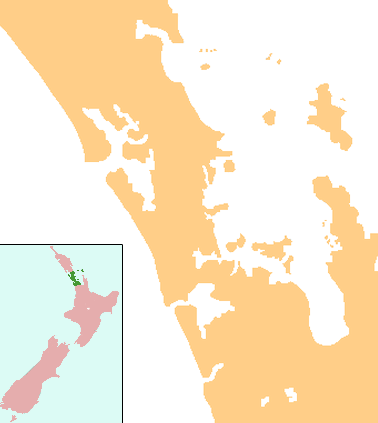
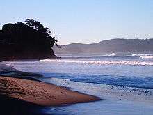
Red Beach is a suburb surrounding the beach of the same name on the Hibiscus Coast, Auckland, New Zealand, at the base of the Whangaparaoa Peninsula. The suburb of Silverdale is to the south-west, and Orewa to the north. The beach is on the Hauraki Gulf and the suburb is bounded by two estuaries, that of the Weiti River to the south and the Orewa River to the north. The population was 6,315 in the 2006 Census, an increase of 654 from 2001.[1]
The Hibiscus Coast Highway runs through the suburb. This was previously State Highway 1[2] and then State Highway 17. The majority of highway traffic now travels along the Northern Motorway inland instead, as the motorway was redesignated as State Highway 1 when an extension was completed in 2009. All road access to the rest of Whangaparaoa Peninsula currently runs through the suburb.
Landmarks and attractions
Popular attractions include:
- The Red Beach Surf Club
- Peninsula Golf Club
- Totara Views
- Panorama Views
Annual events
- Red Beach School Gala
- Streetlight Competition
Education
Red Beach School is a contributing primary (years 1-6) school with a decile rating of 9 and a roll of 643.[3] The school opened in 1989 covering years 1-8, but reduced its age range when Hibiscus Coast Intermediate opened in 1997 (the intermediate later became part of Whangaparaoa College).[4]
KingsWay School is a state integrated composite (years 1-13) school with a decile rating of 10 and a roll of 968.[5] The school provides a non-denominational Christian-based education.[6]
Both schools are coeducational.
Notes
- ↑ Quickstats about Red Beach
- ↑ Peter Dowling (editor) (2004). Reed New Zealand Atlas. Reed Books. pp. map 11. ISBN 0-7900-0952-8.
- ↑ "Te Kete Ipurangi - Red Beach School". Ministry of Education.
- ↑ "About Our School - General Information". Red Beach School. Retrieved 2008-08-26.
- ↑ "Te Kete Ipurangi - Kingsway School". Ministry of Education.
- ↑ "Education Review Report - KingsWay School". Education Review Office. April 2006. Retrieved 2008-08-26.
External links
- Red Beach School website
- KingsWay School website
- Photographs of Red Beach held in Auckland Libraries' heritage collections.
Coordinates: 36°36′15″S 174°42′00″E / 36.6043°S 174.7000°E