Kingdom of Gwent
| Kingdom of Gwent | ||||||||||||
| Teyrnas Gwent | ||||||||||||
| ||||||||||||
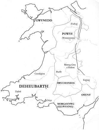 Medieval kingdoms of Wales, showing Gwent in the south-east | ||||||||||||
| Capital | Caerwent Porth-is-Coed | |||||||||||
| Languages | Old Welsh | |||||||||||
| Religion | Celtic Christianity | |||||||||||
| Government | Monarchy | |||||||||||
| Historical era | Middle Ages | |||||||||||
| • | After Roman withdrawal from Britain | 5th century | ||||||||||
| • | First union with Glywysing | 942–974 | ||||||||||
| • | Invasion by Gruffydd ap Llewellyn | 1055 | ||||||||||
| • | Second union with Glywysing | 1063 | ||||||||||
| ||||||||||||
Gwent (Old Welsh: Guent) was a medieval Welsh kingdom, lying between the Rivers Wye and Usk. It existed from the end of Roman rule in Britain in about the 5th century until the Norman conquest of England in the 11th century. Along with its neighbour Glywyssing, it seems to have had a great deal of cultural continuity with the earlier Silures,[1] keeping their own courts and diocese separate from the rest of Wales until their conquest by Gruffydd ap Llywelyn. Although it recovered its independence after his death in 1063, Gwent was the first of the Welsh kingdoms to be overrun following the Norman conquest.
History
Establishment
The area has been occupied since the Paleolithic, with Mesolithic finds at Goldcliff and evidence of growing activity throughout the Bronze and Iron Age.
Gwent came into being after the Romans had left Britain, and was a successor state drawing on the culture of the pre-Roman Silures tribe and ultimately a large part of their Iron Age territories. It took its name from the civitas capital of Venta Silurum, perhaps meaning "Market of the Silures". In the post Roman period, the territory around Venta became the successor kingdom of Guenta, later Gwent, deriving its name directly from the town through the normal sound change in the Brythonic languages from v to gu. The town itself became Caerwent, "Fort Venta".[2] Unlike in other Welsh territories, inhabitants of Caerwent and Caerleon retained the use of defensible Roman town walls throughout the period.[3][4]
Early Gwent
The medieval kingdom was traditionally taken to be the area between the Usk, the Wye, and Severn estuary. To the north, the area adjoined Ewyas and Ergyng (later known as "Archenfield"). According to one Old Welsh genealogy, the founder of the kingdom was Caradoc Freichfras. The earliest centre of the kingdom may have been at Caerwent, the Roman administrative centre, or perhaps Caerleon, formerly a major Roman military base. Welsh saints like Dubricius, Tatheus and Cadoc Christianized the area from the 5th century onwards. According to tradition, in about the 6th century Caradoc moved his court from Caerwent to Portskewett, perhaps meaning nearby Sudbrook. Other suggestions are that Gwent was founded by Erb, possibly a descendant of Caradoc, who may have been a ruler of Ergyng east of the Black Mountains who won control of a wider area to the south.[5][6]
A later monarch was the Christian King Tewdrig who was mortally wounded repelling a pagan Saxon invasion. His son Meurig may have been responsible for uniting Gwent with Glywysing to the west in the 7th century, through marriage.[5] It has been suggested that Meurig's son, Athrwys, may be the origin for King Arthur, although others consider this unlikely.
At times in the 8th century, Gwent and Glywysing appear to have formed a single kingdom. Gwent may also have extended east of the River Wye into areas known as Cantref Coch, which later became the Forest of Dean.[7][8] Its eastern boundary later became established as the Wye, perhaps first determined by Offa of Mercia in the late 8th century, and certainly by Athelstan of England in 927. The area west of the River Usk was Gwynllŵg, which formed part of Glywysing.
Morgannwg
In 931, Morgan ab Owain of Gwent, later known as Morgan Hen (Morgan the Old), was one of the Welsh rulers who submitted to Athelstan's overlordship, and attended him at court in Hereford. However, Gwent remained a distinct Welsh kingdom. In about 942, Gwent and Glywysing were again temporarily united under the name of Morgannŵg by Morgan Hen, but they were broken up again after his death.[9] In 1034 Gwent was invaded by Canute.[10]
Destruction
Gwent's existence as a separate kingdom again temporarily ended when Gruffydd ap Llywelyn won control of the area and Morgannŵg in 1055, so extending his rule over the whole of Wales. However, after Gruffydd's death in 1063, Caradog ap Gruffudd re-established an independent kingdom in Gwent.[5] In 1065 the area was invaded by Earl Harold of Hereford, who attempted to establish a base at Portskewett, but it was razed to the ground by Caradog, and Harold - having by then been crowned King of England - was killed at the Battle of Hastings the following year.[2]
With the Norman invasion of Britain extending westwards after 1067, Caradog's area of control moved into Deheubarth to the west, until his death in 1081. By that time most of Gwent had become firmly under Norman control.[5] However, conflict with the Welsh continued intermittently until 1217, when William Marshal sent troops to retake the castle at Caerleon from the Welsh.
The Normans divided the area, including those areas which they controlled beyond the River Usk, into the Marcher Lordships of Abergavenny, Caerleon, Monmouth, Striguil (Chepstow) and Usk. They built permanent stone castles, many originating from a network of earlier motte and bailey castles. The density of castles of this type and age is amongst the highest in Britain and certainly the rest of the Welsh Marches, with at least 25 castle sites remaining in Monmouthshire alone today.[11]
Legacy
Despite the extinction of the kingdom by 1091, the name Gwent remained in use for the area by the Welsh throughout this period and later centuries. It was traditionally divided by the forested hills of Wentwood (Welsh: Coed Gwent) into Gwent Uwch-coed ("beyond the wood") and Gwent Is-coed ("below the wood"). These terms were transliterated into English as Overwent and Netherwent, the entire area sometimes being known as "Wentland" or "Gwentland".[11][12]
The Marcher Lordships were the basic units of administration for the next 450 or so years, until Henry VIII passed the Laws in Wales Act 1535. This Act abolished the Marcher Lordships and established the County of Monmouthshire, combining the Lordships east of the Usk with Newport (Gwynllŵg or Wentloog) and Caerleon to the west of it.
In the 19th and 20th centuries, writers again began using the name 'Gwent' in a romantic literary way to describe Monmouthshire. In the local government re-organisations of 1974/5, several new administrative areas within Wales were named after medieval kingdoms - Gwent, Dyfed, Powys, and Gwynedd. Gwent as a local government unit again ceased to exist in 1996, when replaced by the unitary local authorities of Newport, Blaenau Gwent, Torfaen, Caerphilly (which included parts of Mid Glamorgan), and Monmouthshire. The name remains as one of the preserved counties of Wales used for certain ceremonial purposes, and also survives in various titles, e.g. Gwent Police, Royal Gwent Hospital, Coleg Gwent and the Newport Gwent Dragons rugby team.
References
- ↑ Miranda Aldhouse-Green &al. Gwent In Prehistory and Early History: The Gwent County History, Vol.1. 2004. ISBN 0-7083-1826-6.
- 1 2 South East Wales in the Early Medieval Period
- ↑ Gatehouse Gazeteer. "Caerwent Town Walls". 10 Dec 2012. Accessed 13 Feb 2013.
- ↑ Gatehouse Gazeteer. "Caerleon Town Walls". 10 Dec 2012. Accessed 13 Feb 2013.
- 1 2 3 4 Raymond Howell, A History of Gwent, 1988, ISBN 0-86383-338-1
- ↑ The Early Welsh Kingdoms, Gwent & Glywysing
- ↑ 1911 Encyclopaedia Britannica
- ↑ R. J. Mansfield, Forest Story, 1965
- ↑ CastleWales.com
- ↑ Thomas Nicholas, Annals and Antiquities of the Counties and County Families of Wales
- 1 2 Griffiths, Ralph A.; Hopkins, Tony; Howell, Ray (2008). The Gwent County History Vol.2: The Age of the Marcher Lords, c.1070-1536. University of Wales Press. ISBN 978-0-7083-2072-3.
- ↑ Camden's Britannia at Caerleon.net