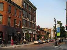
King William Street (Hamilton, Ontario)

King William Street is a Lower City collector road in Hamilton, Ontario, Canada. It starts off at the western-end at James Street North and is a one-way street (Eastbound) until Mary Street, where it becomes a two-way street that ends at Wentworth Street North. It is named after King William IV of the United Kingdom.
History
In 1922, CKOC radio station (1150 on the AM dial) started up. As of April 2007, it is the oldest radio station in English Canada; second oldest overall. On the air since May 1, 1922. Originally ran as Top-40 format, today it's an "Oldies" radio station. [1] In 1927, CHML, (900 on the AM dial), began operations as a response to censorship of political discussions by Hamilton's first radio station, CKOC. The original owners were Maple Leaf Radio Company, and the "HML" in the callsign stood for "Hamilton Maple Leaf". CHML's broadcast station is on Main Street West in the Lower City. [2] Originally, CKOC's broadcast from the corner of King William and John Streets and was an offshoot of the Wentworth Radio and Supply Company owned by Herb Slack. He figured he could sell more radios if he also owned a radio station and in the spring of 1922 the station became only the third radio station in all of Canada. Other broadcast locations over the years for CKOC include, the 11th floor of the Royal Connaught Hotel in the downtown core, the Lister Block building on James & King Williams Streets and a studio on Garfield Avenue near King & Sherman Avenue North. Today the radio station is based on the Mountain on Upper Wentworth Street, just North of Limeridge Mall. [3]
Landmarks


Note: Listing of Landmarks from West to East.
- Hamilton City Centre (Mall, formerly the Eaton's Centre)
- Lloyd D. Jackson Square (Mall)
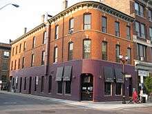
- Lister Block Building
- Homegrown Hamilton
- Club Absinthe
- Downtown Bingo Hall (back-end)
- Geyer Studio
- The Baltimore House
- Manta Contemporary Art Gallery
- Hamilton Central Fire Department (just north of King William Street on John Street North)
- Seventy-Seven Night Club
- The Underground, Steel City Music Venue
- Children's International Learning Centre
- Theatre Aquarius, Dofasco Centre for the Performing Arts, downtown
- Hamilton Regional Police station
- Tweedsmuir Elementary School (demolished in 2006)
- Cathedral High School
Communities
Note: Listing of neighbourhoods from West to East. [4]
- Central - The financial center of Hamilton, Ontario
- Beasley
- Landsdale
Roads that are parallel with King William Street
Lower City Roads:
- Burlington Street, West/East
- Barton Street, West/East
- Cannon Street, West/East
- Wilson Street
- King William Street
- King Street, West/East
- Main Street, West/East; - Queenston Road
- Jackson Street, East
- Hunter Street, West/East
- Augusta Street
- Charlton Avenue, West/East
- Aberdeen Avenue
Niagara Escarpment (Mountain) Roads:
- Concession Street
- Queensdale Avenue West/ East
- Scenic Drive - Fennell Avenue, West/East
- Sanatorium Road
- Mohawk Road, West/East
- Limeridge Road West/East
- Lincoln M. Alexander Parkway - Mud Street, (Hamilton City Road 11)
- Stone Church Road, West/East
 ; Rymal Road, West/East
- Twenty Road
Roads that cross King William Street
Note: Listing of streets from West to East.
- James Street, North
- Hughson Street, North
- John Street, North
- Catharine Street, North
- Ferguson Avenue, North
- Wellington Street, North
- Victoria Avenue, North
- Wentworth Street, North
References
- ↑ "CKOC Radio Official web site". Retrieved 2007-04-25.
- ↑ "The Hamilton Memory Project;" (Press release). The Hamilton Spectator- Souvenir Edition page MP38. June 10, 2006.
- ↑ Foley, Doug (April 16, 2007). "A Tale of Two Stations" (Press release). The Hamilton Spectator.
- ↑ "Hamilton Neighbourhood Boundaries, (map.hamilton.ca)" (PDF). Archived from the original (PDF) on 2007-09-27. Retrieved 2007-05-11.
- MapArt Golden Horseshoe Atlas - Page 647 - Grids G12, G13, G14
External links
Coordinates: 43°15′17″N 79°51′31″W / 43.2548°N 79.8587°W