King George Island (South Shetland Islands)
 Map of King George Island, Antarctica | |
 King George Island | |
| Geography | |
|---|---|
| Location | Antarctica |
| Coordinates | 62°02′S 58°21′W / 62.033°S 58.350°W |
| Archipelago | South Shetland Islands |
| Area | 1,150 km2 (440 sq mi) |
| Length | 95 km (59 mi) |
| Width | 25 km (15.5 mi) |
| Administration | |
|
None | |
| Demographics | |
| Population | around 500 |
| Additional information | |
| Administered under the Antarctic Treaty System | |
King George Island (Argentina: Isla 25 de Mayo, Chile: Isla Rey Jorge, Russian: Ватерло́о Vaterloo) is the largest of the South Shetland Islands, lying 120 km (75 miles) off the coast of Antarctica in the Southern Ocean. The island was named after King George III.
Geography
King George island has three major bays, Maxwell Bay, Admiralty Bay, and King George Bay. Admiralty Bay contains three fjords, and is protected as a Antarctic Specially Managed Area under the Protocol on Environmental Protection to the Antarctic Treaty.[1]

History
The island was first claimed for Britain on 16 October 1819, formally annexed[2][3][4] by Britain as part of the Falkland Islands Dependencies in 1908, and now as part of the separate British Antarctic Territory. The Island was claimed by Chile in 1940, as part of the Chilean Antarctic Territory. It was claimed also by Argentina in 1943, now as part of Argentine Antarctica, called by the Argentines Isla Veinticinco de Mayo (May 25) in honour of their National day. The US and Russia do not recognize these claims, and have formally reserved their right to claim Antarctic territories.
The island was discovered and named by the British explorer William Smith in 1819.[5] It is approximately 95 km (59 mi) long and 25 km (16 mi) wide with a land area of 1,150 square kilometres (444 sq mi). Over 90% of the island's surface is permanently glaciated.[5] In 1821, 11 men of the sealing vessel Lord Melville survived the winter on the island, the first men to do so in Antarctica[6]
Life on the island
The coastal areas of the island are home to a comparatively diverse selection of vegetation and animal life, including elephant, Weddell, and leopard seals, and Adelie, chinstrap and gentoo penguins. There are several other seabirds, including skuas and southern giant petrel, that nest on this island during the summer months.
Human activity

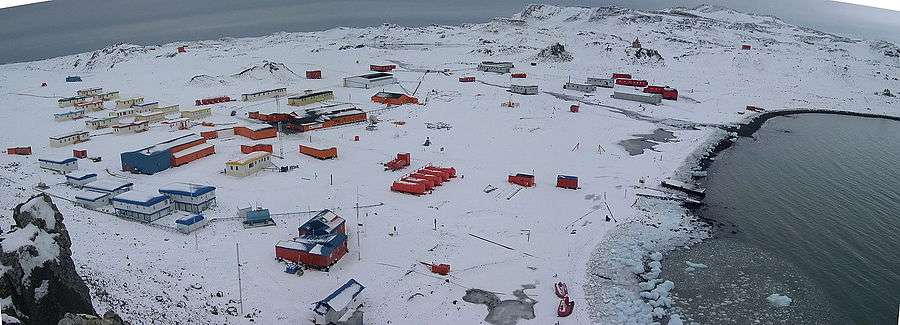
Human habitation of King George Island is limited to research stations belonging to Argentina, Brazil, Chile, China, Ecuador, South Korea, Peru, Poland, Russia, Uruguay, and The United States. Most of these stations are permanently staffed, carrying out research into areas as diverse as biology, ecology, geology, and palaeontology. Base Presidente Eduardo Frei Montalva, the Chilean Station on the Fildes Peninsula, is operated as a permanent village with an airstrip (with large hangar and control tower along with other buildings), cafeterias for personnel of its several agencies there, a bank, a post office and comfortable ranch-style family homes with children. Chile (like Argentina and Great Britain) regards all of the Antarctic Peninsula and South Shetland Islands as part of that country's territory; however, the terms of the Antarctic Treaty allow Chile to colonize the Fildes Peninsula without overtly pursuing its territorial claims.[7] The Chinese "Great Wall" base features an indoor multipurpose room which serves as a full-size basketball court.
In 2004, a Russian Orthodox church, Trinity Church, was opened on the island near Russia's Bellingshausen Station. The church, one of the southernmost in the world and one of the few permanent structures in Antarctica, is permanently manned by a priest.
In October 2013, American heavy metal band Metallica announced that it would perform a concert sponsored by The Coca-Cola Company at Carlini Station heliport.[8] The concert took place on December 8, 2013.[9]
A small amount of specialised tourist activity also takes place during summer, including an annual marathon, known as the Antarctic marathon.
The Fildes Peninsula 7 kilometres (4.3 mi) long, forms the SW extremity of the island. It was named from association with nearby Fildes Strait by the UK-APC in 1960.
Arctowski lighthouse at Arctowski Station is the most southerly lighthouse of the world.[10]
NOAA runs a seasonal research base for penguin studies on Admiralty Bay. This small station, dubbed Copacabana, operates in the Antarctic summer only, but is used as a survival hut in the winter.[11]
See also
References
- ↑ http://www.admiraltybayasma.aq/index_eng.html
- ↑ Odd Gunnar Skagestad. Norsk Polar Politikk: Hovedtrekk og Utvikslingslinier, 1905-1974. Oslo: Dreyers Forlag, 1975
- ↑ Thorleif Tobias Thorleifsson. Bi-polar international diplomacy: The Sverdrup Islands question, 1902-1930. Master of Arts Thesis, Simon Fraser University, 2004.
- ↑ Robert K. Headland, The Island of South Georgia, Cambridge University Press, 1984.
- 1 2 Campbell, David G. (2002). The Crystal Desert: Summers in Antarctica, p. 4. Houghton-Mifflin Books. ISBN 0-618-21921-8.
- ↑ Mills, William James (2003). Exploring Polar Frontiers: A Historical Encyclopedia, p. 353. Santa Barbara: ABC-CLIO, Inc. ISBN 1-57607-422-6.
- ↑ National Geographic, December 2001
- ↑ http://money.cnn.com/2013/10/25/news/companies/metallica-coca-cola-antarctica/index.html
- ↑ http://www.spin.com/#articles/metallica-concert-antarctica-video-freeze-em-all/
- ↑ http://web.archive.org/web/20091027115012/http://www.geocities.com/antarcticaaz/
- ↑ http://swfsc.noaa.gov/gs/default.aspx?aid=411
Bibliography
- A.G.E. Jones, "Captain William Smith and the Discovery of New South Shetland", Geographical Journal, Vol. 141, No. 3 (November 1975), pp. 445–461
- Alan Gurney, Below the Convergence: Voyages Toward Antarctica, 1699-1839, Penguin Books, New York, 1998
- Revista de la Asociación Geológica Argentina 62 (1): pp 35–43 Spanish
External links
| Wikimedia Commons has media related to King George Island. |
- The SCAR King George Island GIS Project provides an interactive map of the island.
- Biodiversity at Ardley Island Small place near King George Island, special protected area.
- Report From Antarctica: Countries Maneuver for Potential Future Land Grab
Coordinates: 62°02′S 58°21′W / 62.033°S 58.350°W