King's Hill, Hampshire
| King's Hill | |
|---|---|
| Highest point | |
| Elevation | 218 m (715 ft) [1] |
| Prominence | 46 m (151 ft) [1] |
| Parent peak | Butser Hill [1] |
| Coordinates | 51°08′01″N 1°02′27″W / 51.1335°N 1.0407°WCoordinates: 51°08′01″N 1°02′27″W / 51.1335°N 1.0407°W |
| Geography | |
| Location | Hampshire, England |
| Parent range | Hampshire Downs |
| OS grid | SU672375 |
| Topo map | OS Landranger |
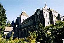
Alton Abbey near the summit of King's Hill
King's Hill is one of the highest points in the county of Hampshire, England. It is part of the Hampshire Downs and reaches 218 metres (715 ft) above sea level.
King's Hill is situated in the parish of Bentworth. It lies on the Abbey Road between the Hampshire villages of Medstead and Beech. To the northeast is Alton Abbey. Chawton Park Wood lies to the south of the open hilltop.[2]
References
- 1 2 3 Summit Listings by Relative Height by Mark Jackson, compiled by Jonathan de Ferranti. Accessed on 15 May 2013.
- ↑ Ordnance Survey 1:50,000 Landranger series.
This article is issued from Wikipedia - version of the 2/26/2014. The text is available under the Creative Commons Attribution/Share Alike but additional terms may apply for the media files.