Kilncadzow
Coordinates: 55°43′06″N 3°46′33″W / 55.718429°N 03.77597°W
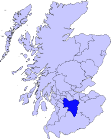
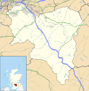
Kilncadzow (previously Kilcadzow,[1] Kilcago[2]) is a small village in rural South Lanarkshire, lying roughly 5 km north of Lanark and 5 km east-southeast of Carluke, on the A721 road.
Toponymy
The name 'Kilncadzow' is pronounced kill-caig-eh; for the unintuitive spelling, see yogh.
Recently, the National Library of Scotland has made several old maps of the area available online. One of the oldest is dated 1747-1755 (The General Roy map). This clearly shows Kilncadzow as 'Kilcago'.
History
The Roman road which passed through Clydesdale to the western extremity of the Antonine Wall can be found in Kilncadzow.[1] An abandoned stone quarry - thought to date from the 18th century - is located on common land, just north of the A721.
As an agricultural area, the village has many farms in close proximity. These include The Hill of Kilncadzow, The Hole of Kilncadzow, Greenbank, Collilaw, Birkenhead, The Drums, Craigend, Craighead, Gowanside and Leemuir. The three farms which were within the village - Townhead, Mid Town and West Town (all thought to date from the 18th century) - are no longer used as farms. A school (now the community hall[3]) was built in the late 19th century to provide primary education for the children of the area. During the 20th century, council housing was provided for agricultural workers.
Location
The village is located primarily on two roads - Carnwath Road (the A721) and Craigenhill Road. There are approximately 40 houses in the village, the majority of which were constructed during the 1970s and '80s. However, a local farmer has plans to expand the village rapidly in the near future.
The village enjoys panoramic views to the south, east and west - indeed, views of Tinto Hill, Lanark and Douglas are most prominent. The best views are from Kilncadzow Law, upon which a radio transmitter is located.
Most villagers commute to work; however, there are no public transport facilities and ownership or access to a vehicle is almost essential. Transport links and local amenities are located mainly in Carluke and Lanark; however, the village does have a bakery, a community hall (in need of considerable investment) and a swing park.
Craigenhill Road’s speed limit was reduced from the national speed limit to 30 mph. After many years of campaigning by local residents the speed limit on Carnwath Road was reduced to 40 mph in 2009; however, vehicular traffic regularly travels far in excess of this limit, seemingly unaware of the dangers.
Commerce
A number of non-farming businesses are based in Kilncadzow, including a riding school, a farrier, The Village Bakery (renowned locally for producing larger-than-normal cakes and pastries) and a joiner.
Education
Since the closure of Kilncadzow School, children of the village have attended a number of different schools, including Crawforddyke Primary School, Carluke High School, Lanark Grammar. Today, the children of Kilncadzow usually attend Crawforddyke Primary School and Carluke High School - indeed, South Lanarkshire Council provides transport to these schools - however, it is possible for children to attend other schools including St Athanasius and St Aidans.
References
- 1 2 British History Online, "A Topographical Dictionary of Scotland - Kilcadzow", retrieved 20 December 2007
- ↑ "William Roy Military Survey of Scotland - 1747-55", retrieved 07 March 2011
- ↑ South Lanarkshire Council, "Kilncadzow Village Hall", retrieved 14 August 2007
External links
| Wikimedia Commons has media related to Kilncadzow. |