Kill Van Kull
Coordinates: 40°38′38″N 74°07′12″W / 40.644°N 74.120°W
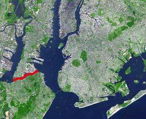

The Kill Van Kull is a tidal strait between Staten Island, New York, and Bayonne, New Jersey, in the United States. Approximately 3 miles (4.8 km) long and 1,000 feet (305 m) wide, it connects Newark Bay with Upper New York Bay.[1] The Robbins Reef Light marks the eastern end of the Kill, Bergen Point its western end. Spanned by the Bayonne Bridge, it is one of the most heavily travelled waterways in the Port of New York and New Jersey.
Historically it has been one of the most important channels for the commerce of the region, providing a passage for marine traffic between Upper New York Bay and the industrial towns of northeastern New Jersey. During the colonial era it played a significant role in travel between New York and the southern colonies, with passengers changing from ferries to coaches at Elizabethtown (now Elizabeth).
Since the final third of the 20th century, it has provided the principal access for oceangoing container ships to Port Newark-Elizabeth Marine Terminal, the busiest port facility in the eastern United States, and Howland Hook Marine Terminal. To accommodate the passage of ever-larger ships, the strait has required continued dredging and deepening. In many areas the sandy bottom has been excavated down to rock and now requires blasting.[2][3][4][5] In addition, plans are underway to renovate the Bayonne Bridge so that larger container ships can travel the Kill Van Kull.[6]
Etymology
Kill Van Kull translates as "channel from the pass" or "ridge". The name of the sister channel to the Kill Van Kull, the nearby Arthur Kill, is an anglicisation of achter kill, meaning "back channel", referring to its location "behind" Staten Island.
The name "Kill Van Kull" has its roots in the early 17th century during the Dutch colonial era, when the region was part of New Netherland. The naming of places by early explorers and settlers during the era often referred to a location in reference to other places based on its shape, topography, or other geographic qualities. The area around Newark Bay was called Achter Kol.[7] The bay lies behind Bergen Hill, the emerging ridge of the Hudson Palisades, which begins on Bergen Neck, the peninsula between it and the Upper New York Bay. Behind or achter the ridge, was a col or passage to the interior. Kill comes from the Middle Dutch word kille, meaning "riverbed", "water channel", or "stream". During the British colonial era the bay was known as Cull Bay.[8]
Gallery
-

View of the Kill from the Bayonne Bridge
-

The United States Army Corps of Engineers dredge brings up debris of blasted bedrock during the widening of the channel by 50 feet
-

Ships in Upper New York Bay wait to enter the Kill
See also
- Port Richmond, Staten Island
- Port Johnston Coal Docks
- Geography of New York-New Jersey Harbor Estuary
- List of crossings of the Hackensack River
- List of crossings of the Lower Passaic River
- Sandy Hook Pilots
References
- ↑ Hudson County New Jersey Street Map. Hagstrom Map Company, Inc. 2008. ISBN 0-88097-763-9.
- ↑ Ports and waterways safety: Kill Van Kull Channel et al., NY and NJ, Federal Register, April 15, 1999 (Nbr. Vol. 64, No. 72)
- ↑ Nadler: Kill Van Kull Fiasco Shows Red Hook’s Importance, Congressional Press Release
- ↑ Kill Van Kull & Newark Bay Channel Deepening, Port Authority of New York and New Jersey, 30. April 1999
- ↑ Corps Announces Start of Test Blasting Work for Kill Van Kull 50 Foot Deepening, U. S. Army Corps Of Engineers, Media Advisory, 1. August 2005
- ↑ Shawn Boburg. $1B Bayonne Bridge Renovation Six Months Ahead of Schedule, Bergen County Record, 19 July 2012.
- ↑ "Historical marker of Achter Col "colony"". Historical Marker Database. Retrieved 2010-09-02.
- ↑ Grabas, Joseph A. "Land Speculation and Proprietary Beginnings of New Jersey" (PDF). The Advocate. New Jersey Land Title Association. XVI (4): 3, 20, 14. Retrieved April 15, 2010.
- Water upgrade for Kill Van Kull, Staten Island Advance, May 20, 2010
- New York Daily News articles re: Kill Van Kull
| Bridges of the Newark Bay | ||||
|---|---|---|---|---|
| ||||