Hotan Prefecture
| Hotan Prefecture 和田地区 • خوتەن ۋىلايىتى | |
|---|---|
| Prefecture | |
|
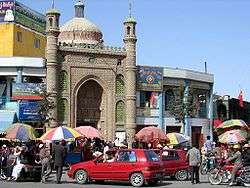
Hotan City | |
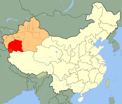 Hotan prefecture (red) in Xinjiang (orange) | |
| Country | People's Republic of China |
| Region | Xinjiang |
| Time zone | China Standard (UTC+8) |
| Website | Hotan(Hetian) Prefecture Government |
The Hotan Prefecture (Chinese: 和田地区; pinyin: Hétián Dìqū; Uyghur: خوتەن ۋىلايىتى; Хотән Вилайити; Xoten Wilayiti; Hotən Vilayiti)[1] is located in the south-western part of the Xinjiang Uyghur Autonomous Region, bordering the Tibet Autonomous Region to the south. It is sometimes (unofficially) spelled as Khotan.
Administrative divisions
The Hotan Prefecture is divided into one county-level city and seven counties:
 | |||||||||
| # | Name | Simplified Chinese | Hanyu Pinyin | Uyghur (UEY) | Uyghur Latin (ULY) | Population (2010 Census) | Area (km²) | Density (/km²) | |
|---|---|---|---|---|---|---|---|---|---|
| 1 | Hotan | 和田市 | Hétián Shì | خوتەن شەھىرى | Hoten Shehiri | 322,300 | 466 | 691.63 | |
| 2 | Hotan County | 和田县 | Hétián Xiàn | خوتەن ناھىيىسى | Hoten Nahiyisi | 269,941 | 41,403 | 6.51 | |
| 3 | Moyu [Karakax] County | 墨玉县 | Mòyù Xiàn | قاراقاش ناھىيىسى | Qaraqash Nahiyisi | 500,114 | 25,789 | 19.39 | |
| 4 | Pishan [Guma] County | 皮山县 | Píshān Xiàn | گۇما ناھىيىسى | Guma Nahiyisi | 258,210 | 39,742 | 6.49 | |
| 5 | Lop County | 洛浦县 | Luòpǔ Xiàn | لوپ ناھىيىسى | Lop Nahiyisi | 232,916 | 14,314 | 16.27 | |
| 6 | Qira County | 策勒县 | Cèlè Xiàn | چىرا ناھىيىسى | Chira Nahiyisi | 147,050 | 31,688 | 4.64 | |
| 7 | Yutian [Keriya] County | 于田县 | Yútián Xiàn | كېرىيە ناھىيىسى | Kériye Nahiyisi | 249,899 | 39,095 | 6.39 | |
| 8 | Minfeng [Niya] County | 民丰县 | Mínfēng Xiàn | نىيە ناھىيىسى | Niye Nahiyisi | 33,932 | 56,760 | 0.59 | |
See also
Footnotes
- ↑ The official spelling is "Hotan" according to Zhōngguó dìmínglù 中国地名录 (Beijing, SinoMaps Press 中国地图出版社 1997); ISBN 7-5031-1718-4; p. 304.
External links
Coordinates: 37°07′N 79°55′E / 37.117°N 79.917°E
This article is issued from Wikipedia - version of the 8/19/2016. The text is available under the Creative Commons Attribution/Share Alike but additional terms may apply for the media files.