Khost Province
| Khost خوست | |
|---|---|
| Province | |
|
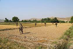
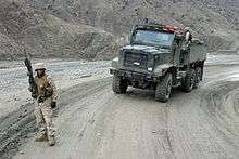
U.S. soldiers in Khost province (June 2013) | |
 Map of Afghanistan with Khost highlighted | |
| Coordinates (Capital): 33°24′N 69°54′E / 33.4°N 69.9°ECoordinates: 33°24′N 69°54′E / 33.4°N 69.9°E | |
| Country |
|
| Capital | Khost |
| Government | |
| • Governor | Hukam Khan Habibi |
| Area | |
| • Total | 4,151.5 km2 (1,602.9 sq mi) |
| Population (2015)[1] | |
| • Total | 574,582 |
| • Density | 140/km2 (360/sq mi) |
| Time zone | UTC+4:30 |
| Area code(s) | AF-KHO |
| Main languages | Pashto |
Khost (Pashto: خوست, Persian: خوست) is one of the 34 provinces of Afghanistan, located in the eastern part of the country next to Pakistan's Federally Administered Tribal Areas (FATA). Khost province used to be part of Paktia province in the past. The city of Khost serves as the capital of Khost province. The population of the province is around 546,800,[2] which is mostly a tribal society. Khost Airport serves the province for domestic flights to Afghanistan's capital, Kabul.
History
Recent history
In September 2011, work on the construction of Khost International Airport began. It is estimated the airport will cost $2.5 million. The funds for the project are being provided by the Afghan government. The airport will be located in a desert between Ismailkhel and Tani District.[3][4]
Politics and governance
The current governor of the Province is Abdul Jabbar Naeemi.[5] The city of Khost is the capital of Khost province. All law enforcement activities throughout the province are controlled by the Afghan National Police (ANP). The border of Afghanistan's Khost province with neighboring Pakistan's FATA is monitored and protected by the Afghan Border Police (ABP), which is part of the ANP. The border is called the Durand Line and is known to be one of the most dangerous in the world due to heavy militant activities and illegal smugglings. A provincial police chief is assigned to lead both the ANP and ABP. The police chief represents the Ministry of the Interior in Kabul. The ANP is backed by other Afghan National Security Forces (ANSF), including the NATO-led forces.
Healthcare
The percentage of households with clean drinking water increased from 34% in 2005 to 35% in 2011.[6] The percentage of births attended to by a skilled birth attendant increased from 18% in 2005 to 32% in 2011.[6]
Education
The overall literacy rate (6+ years of age) fell from 28% in 2005 to 15% in 2011.[6] The overall net enrolment rate (6–13 years of age) fell from 38% in 2005 to 37% in 2011.[6]
Demographics


The population of Khost province is around 546,800.[2] The Pashtun people make up 99% of the population, with the remaining 1% being Tajiks and others.[5]
Districts
| District | Capital | Population (2015) | Area[7] | Notes |
|---|---|---|---|---|
| Bak | 22,561 | |||
| Gurbuz | 26,762 | |||
| Zazi Maidan | 23,197 | |||
| Khost Matun|Capital | 140,642 | |||
| Mandozayi | 57,602 | |||
| Musakhel | 41,882 | |||
| Nadir Shah Kot | 32,522 | |||
| Qalandar | 10,440 | |||
| Sabari | 72,364 | |||
| Shamal | 13,920 | Shifted from Paktia Province in 2005 | ||
| Spera | 24,841 | |||
| Tani | 60,842 | |||
| Tirazayi | 45,602 |
Water
Khost Province is traversed by the Kurram River, which rises from the Rokian Defile, passes through the district, and then enters the "country of the Turis or the Kurram Valley".[8]
Photos
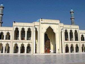 Mosque in the city of Khost |
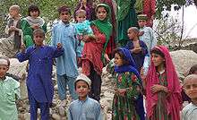 Pashtun children |
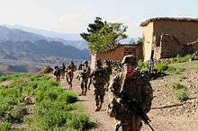
 A U.S. Marine, assigned to Weapons Company, 3rd Battalion, 3rd Marine Regiment, provides security while in the Khowst-Gardez Pass. |
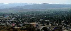 Khost city |
 Tanio area |
See also
References
- ↑ Afghanistan at GeoHive
- 1 2 "Settled Population of Khost province by Civil Division, Urban, Rural and Sex-2012-13" (PDF). Islamic Republic of Afghanistan: Central Statistics Organization. Retrieved 2014-01-18.
- ↑ Muhammad Haroon, ed. (December 7, 2013). "Official wants Khost Airport contract reconsidered". Pajhwok Afghan News. Retrieved October 30, 2014.
- ↑ Muhammad Haroon, ed. (September 10, 2014). "Delay in completion of airport deplored". [Pajhwok Afghan News. Retrieved October 30, 2014.
- 1 2 "Khost Province" (PDF). Program for Culture & Conflict Studies. Naval Postgraduate School. Retrieved 2014-01-18.
- 1 2 3 4 Archive, Civil Military Fusion Centre, https://www.cimicweb.org/AfghanistanProvincialMap/Pages/Khost.aspx
- ↑ Afghanistan Geographic & Thematic Layers
- ↑ Imperial gazetteer of India: provincial series, Volume 20. Publisher Supt. of Govt. Print., 1908
- Blowback: The Costs and Consequences of American Empire, by Chalmers Johnson, ISBN 0-8050-6239-4
- "Ghost Wars"
External links
| Wikimedia Commons has media related to Khost Province. |
- Khost Province by the Naval Postgraduate School
- Khost Province by the Institute for the Study of War
 |
Paktia Province | | ||
| |
Federally Administered Tribal Areas, | |||
| ||||
| | ||||
| Paktika Province |