Khanty-Mansi Autonomous Okrug
| Khanty-Mansi Autonomous Okrug — Yugra Ханты-Мансийский автономный округ — Югра (Russian) | |||
|---|---|---|---|
| — Autonomous okrug — | |||
| |||
|
| |||
| |||
|
| |||
| Political status | |||
| Country | Russia | ||
| Federal district | Urals[1] | ||
| Economic region | West Siberian[2] | ||
| Established | December 10, 1930 | ||
| Administrative center | Khanty-Mansiysk | ||
| Government (as of March 2011) | |||
| • Governor | Natalya Komarova[3] | ||
| • Legislature | Duma | ||
| Statistics | |||
| Area (as of the 2002 Census)[4] | |||
| • Total | 534,800 km2 (206,500 sq mi) | ||
| Area rank | 9th | ||
| Population (2010 Census)[5] | |||
| • Total | 1,532,243 | ||
| • Rank | 29th | ||
| • Density[6] | 2.87/km2 (7.4/sq mi) | ||
| • Urban | 91.5% | ||
| • Rural | 8.5% | ||
| Time zone(s) | YEKT (UTC+05:00)[7] | ||
| ISO 3166-2 | RU-KHM | ||
| License plates | 86 | ||
| Official languages | Russian[8] | ||
| Official website | |||


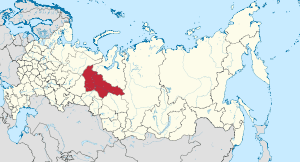
Khanty-Mansi Autonomous Okrug — Yugra or Khanty-Mansiysk Autonomous Okrug – Ugra[9] (Russian: Ха́нты-Манси́йский автоно́мный о́круг — Югра́, Khanty-Mansiysky avtonomny okrug – Yugra), also Khanty-Mansia, is a federal subject of Russia (an autonomous okrug of Tyumen Oblast). Population: 1,532,243 (2010 Census).[5]
The people native to the region are the Khanty and the Mansi, known collectively as Ob Ugric people. The local languages, Khanty language and Mansi language, enjoy special status in the autonomous okrug and along with their distant relative Hungarian are part of the Ugric branch of the Finno-Ugric languages. Russian remains the only official language.
In 2012, the majority (51%)[10] of the oil produced in Russia comes from Khanty–Mansi Autonomous Okrug, giving the region great economic importance.
History
The okrug was established on December 10, 1930, as Ostyak–Vogul National Okrug (Остя́ко-Вогу́льский национа́льный о́круг). In October 1940, it was renamed the Khanty-Mansi National Okrug. In 1977, along with other national okrugs of the Russian SFSR, it became an autonomous okrug (Khanty-Mansi Autonomous Okrug). The administrative center is Khanty-Mansiysk. In 2003, the word "Yugra" was appended to the official name.
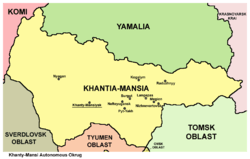
Geography
The okrug occupies the central part of the West Siberian Plain.
Principal rivers include the Ob and its tributary the Irtysh.
The northeasterly line of equal latitude and longitude traverses the Khanty–Mansi Autonomous Okrug.
Administrative divisions
Demographics
Population: 1,532,243 (2010 Census);[5] 1,432,817 (2002 Census);[11] 1,268,439 (1989 Census).[12]
Khanty–Mansi Autonomous Okrug has an area of 523,100 km², but the area is sparsely populated. The administrative center is Khanty-Mansiysk, but the largest cities are Surgut, Nizhnevartovsk, and Nefteyugansk.
Ethnic groups
The indigenous population (Khanty, Mansi, and Nenets) is only 2.2% of the total population in the Khanty-Mansi Autonomous Okrug. The exploitation of natural gas in Khanty-Mansi Autonomous Okrug has attracted immigrants from all over the former Soviet Union. The 2010 Census counted twenty-five ethnic groups of more than two thousand persons each. The ethnic composition is as follows:
Population of Khanty-Mansi Autonomous Okrug:[13]
| Ethnic Group | % |
|---|---|
| Russian | 68.1% |
| Tatar | 7.6% |
| Ukrainian | 6.4% |
| Bashkir | 2.5% |
| Azeri | 1.8% |
| Khanty | 1.3% |
| Belarusians | 1% |
| Kumyk | 1% |
| Chuvash | 0.9% |
| Lezgin | 0.9% |
| Mansi | 0.8% |
| Moldovan | 0.7% |
| Uzbek | 0.7% |
| Chechen | 0.5% |
| German | 0.5% |
| Armenian | 0.4% |
| Other | 5.9% |
Historical population figures are shown below:
| Ethnic group |
1939 Census | 1959 Census | 1970 Census | 1979 Census | 1989 Census | 2002 Census | 2010 Census1 | |||||||||
|---|---|---|---|---|---|---|---|---|---|---|---|---|---|---|---|---|
| Number | % | Number | % | Number | % | Number | % | Number | % | Number | % | Number | % | |||
| Khanty | 12,238 | 13.1% | 11,435 | 9.2% | 12,222 | 4.5% | 11,219 | 2.0% | 11,892 | 0.9% | 17,128 | 1.2% | 19,068 | 1.3% | ||
| Mansi | 5,768 | 6.2% | 5,644 | 4.6% | 6,684 | 2.5% | 6,156 | 1.1% | 6,562 | 0.5% | 9,894 | 0.7% | 10,977 | 0.8% | ||
| Nenets | 852 | 0.9% | 815 | 0.7% | 940 | 0.3% | 1,003 | 0.2% | 1,144 | 0.1% | 1,290 | 0.1% | 1,438 | 0.1% | ||
| Komi | 2,436 | 2.6% | 2,803 | 2.3% | 3,150 | 1.2% | 3,105 | 0.5% | 3,000 | 0.2% | 3,081 | 0.2% | 2,364 | 0.2% | ||
| Russians | 67,616 | 72.5% | 89,813 | 72.5% | 208,500 | 76.9% | 423,792 | 74.3% | 850,297 | 66.3% | 946,590 | 66.1% | 973,978 | 68.1% | ||
| Ukrainians | 1,111 | 1.2% | 4,363 | 3.5% | 9,986 | 3.7% | 45,484 | 8.0% | 148,317 | 11.6% | 123,238 | 8.6% | 91,323 | 6.4% | ||
| Tatars | 2,227 | 2.4% | 2,938 | 2.4% | 14,046 | 5.2% | 36,898 | 6.5% | 97,689 | 7.6% | 107,637 | 7.5% | 108,899 | 7.6% | ||
| Others | 1,026 | 1.1% | 6,115 | 4.9% | 15,629 | 5.8% | 43,106 | 7.6% | 163,495 | 12.7% | 223,959 | 15.6% | 173,536 | 12.6% | ||
| 1 102,138 people were registered from administrative databases, and could not declare an ethnicity. It is estimated that the proportion of ethnicities in this group is the same as that of the declared group.[14] | ||||||||||||||||
Vital statistics
| Average population (x 1000) | Live births | Deaths | Natural change | Crude birth rate (per 1000) | Crude death rate (per 1000) | Natural change (per 1000) | Fertility rates | |
|---|---|---|---|---|---|---|---|---|
| 1970 | 281 | 5 959 | 2 025 | 3 934 | 21.2 | 7.2 | 14.0 | |
| 1975 | 415 | 9 450 | 2 572 | 6 878 | 22.8 | 6.2 | 16.6 | |
| 1980 | 649 | 13 901 | 4 116 | 9 785 | 21.4 | 6.3 | 15.1 | |
| 1985 | 1 041 | 25 130 | 4 863 | 20 267 | 24.1 | 4.7 | 19.5 | |
| 1990 | 1 274 | 21 812 | 5 354 | 16 458 | 17.1 | 4.2 | 12.9 | |
| 1991 | 1 276 | 19 060 | 5 884 | 13 176 | 14.9 | 4.6 | 10.3 | |
| 1992 | 1 270 | 15 849 | 7 132 | 8 717 | 12.5 | 5.6 | 6.9 | |
| 1993 | 1 274 | 14 531 | 9 401 | 5 130 | 11.4 | 7.4 | 4.0 | 1,59 |
| 1994 | 1 286 | 15 120 | 9 937 | 5 183 | 11.8 | 7.7 | 4.0 | 1,59 |
| 1995 | 1 298 | 14 418 | 10 041 | 4 377 | 11.1 | 7.7 | 3.4 | 1,46 |
| 1996 | 1 310 | 14 469 | 9 508 | 4 961 | 11.0 | 7.3 | 3.8 | 1,39 |
| 1997 | 1 330 | 14 640 | 8 497 | 6 143 | 11.0 | 6.4 | 4.6 | 1,34 |
| 1998 | 1 351 | 15 600 | 8 164 | 7 436 | 11.5 | 6.0 | 5.5 | 1,39 |
| 1999 | 1 359 | 14 728 | 8 476 | 6 252 | 10.8 | 6.2 | 4.6 | 1,29 |
| 2000 | 1 372 | 15 579 | 9 426 | 6 153 | 11.4 | 6.9 | 4.5 | 1,34 |
| 2001 | 1 398 | 17 130 | 9 863 | 7 267 | 12.3 | 7.1 | 5.2 | 1,43 |
| 2002 | 1 426 | 19 051 | 9 829 | 9 222 | 13.4 | 6.9 | 6.5 | 1,54 |
| 2003 | 1 445 | 19 883 | 10 000 | 9 883 | 13.8 | 6.9 | 6.8 | 1,58 |
| 2004 | 1 456 | 20 377 | 9 828 | 10 549 | 14.0 | 6.8 | 7.2 | 1,59 |
| 2005 | 1 466 | 19 958 | 10 415 | 9 543 | 13.6 | 7.1 | 6.5 | 1,54 |
| 2006 | 1 476 | 20 366 | 10 077 | 10 289 | 13.8 | 6.8 | 7.0 | 1,56 |
| 2007 | 1 487 | 21 887 | 10 093 | 11 794 | 14.7 | 6.8 | 7.9 | 1,66 |
| 2008 | 1 500 | 23 197 | 10 215 | 12 982 | 15.5 | 6.8 | 8.7 | 1,74 |
| 2009 | 1 513 | 23 840 | 10 107 | 13 733 | 15.8 | 6.7 | 9.1 | 1,77 |
| 2010 | 1 527 | 25 089 | 10 447 | 14 642 | 16.4 | 6.8 | 9.6 | 1,84 |
| 2011 | 1 543 | 25 335 | 10 072 | 14 642 | 16.4 | 6.5 | 9.9 | 1,86 |
| 2012 | 1 558 | 27 686 | 9 949 | 17 737 | 17.6 | 6.3 | 11.3 | 2,02 |
Religion


According to a 2012 official survey[15] 38.1% of the population of Yugra adheres to the Russian Orthodox Church, 5% are unaffiliated generic Christians, 1% of the population adheres to the Slavic native faith (Rodnovery) or to Khanty-Mansi native faith. Muslims (mostly Tatars) constitute 11% of the population. In addition, 23% of the population declares to be spiritual but not religious, 11% is atheist, and 10.9% follows other religions or did not give an answer to the question.[15]
Transport
In Khanty-Mansi Autonomous Okrug, the primary transport of goods is by water and railway transport; 29% is transported by road, and 2% by aviation. The total length of railway tracks 1,106 km. The length of roads is more than 18,000 km.
See also
- List of Chairmen of the Duma of Khanty-Mansi Autonomous Okrug
References
- ↑ Президент Российской Федерации. Указ №849 от 13 мая 2000 г. «О полномочном представителе Президента Российской Федерации в федеральном округе». Вступил в силу 13 мая 2000 г. Опубликован: "Собрание законодательства РФ", №20, ст. 2112, 15 мая 2000 г. (President of the Russian Federation. Decree #849 of May 13, 2000 On the Plenipotentiary Representative of the President of the Russian Federation in a Federal District. Effective as of May 13, 2000.).
- ↑ Госстандарт Российской Федерации. №ОК 024-95 27 декабря 1995 г. «Общероссийский классификатор экономических регионов. 2. Экономические районы», в ред. Изменения №5/2001 ОКЭР. (Gosstandart of the Russian Federation. #OK 024-95 December 27, 1995 Russian Classification of Economic Regions. 2. Economic Regions, as amended by the Amendment #5/2001 OKER. ).
- ↑ Official website of Khanty–Mansi Autonomous Okrug. Natalya Vladimirovna Komarova, Governor of Khanty–Mansi Autonomous Okrug (Russian)
- ↑ Федеральная служба государственной статистики (Federal State Statistics Service) (2004-05-21). "Территория, число районов, населённых пунктов и сельских администраций по субъектам Российской Федерации (Territory, Number of Districts, Inhabited Localities, and Rural Administration by Federal Subjects of the Russian Federation)". Всероссийская перепись населения 2002 года (All-Russia Population Census of 2002) (in Russian). Federal State Statistics Service. Retrieved 2011-11-01.
- 1 2 3 Russian Federal State Statistics Service (2011). "Всероссийская перепись населения 2010 года. Том 1" [2010 All-Russian Population Census, vol. 1]. Всероссийская перепись населения 2010 года (2010 All-Russia Population Census) (in Russian). Federal State Statistics Service. Retrieved June 29, 2012.
- ↑ The density value was calculated by dividing the population reported by the 2010 Census by the area shown in the "Area" field. Please note that this value may not be accurate as the area specified in the infobox is not necessarily reported for the same year as the population.
- ↑ Правительство Российской Федерации. Федеральный закон №107-ФЗ от 3 июня 2011 г. «Об исчислении времени», в ред. Федерального закона №271-ФЗ от 03 июля 2016 г. «О внесении изменений в Федеральный закон "Об исчислении времени"». Вступил в силу по истечении шестидесяти дней после дня официального опубликования (6 августа 2011 г.). Опубликован: "Российская газета", №120, 6 июня 2011 г. (Government of the Russian Federation. Federal Law #107-FZ of June 31, 2011 On Calculating Time, as amended by the Federal Law #271-FZ of July 03, 2016 On Amending Federal Law "On Calculating Time". Effective as of after sixty days following the day of the official publication.).
- ↑ Official on the whole territory of Russia according to Article 68.1 of the Constitution of Russia.
- ↑ "GENERAL INFORMATION". The official site of the Khanty-Mansi Autonomous Okrug — Yugra. 2012-08-29. Retrieved 2015-04-18.
- ↑ В Ханты-Мансийском автономном округе добыта 10-миллиардная тонна нефти
- ↑ Russian Federal State Statistics Service (May 21, 2004). "Численность населения России, субъектов Российской Федерации в составе федеральных округов, районов, городских поселений, сельских населённых пунктов – районных центров и сельских населённых пунктов с населением 3 тысячи и более человек" [Population of Russia, Its Federal Districts, Federal Subjects, Districts, Urban Localities, Rural Localities—Administrative Centers, and Rural Localities with Population of Over 3,000] (XLS). Всероссийская перепись населения 2002 года [All-Russia Population Census of 2002] (in Russian). Retrieved August 9, 2014.
- ↑ Demoscope Weekly (1989). "Всесоюзная перепись населения 1989 г. Численность наличного населения союзных и автономных республик, автономных областей и округов, краёв, областей, районов, городских поселений и сёл-райцентров" [All Union Population Census of 1989: Present Population of Union and Autonomous Republics, Autonomous Oblasts and Okrugs, Krais, Oblasts, Districts, Urban Settlements, and Villages Serving as District Administrative Centers]. Всесоюзная перепись населения 1989 года [All-Union Population Census of 1989] (in Russian). Институт демографии Национального исследовательского университета: Высшая школа экономики [Institute of Demography at the National Research University: Higher School of Economics]. Retrieved August 9, 2014.
- ↑ "National Composition of Population for Regions of the Russian Federation" (XLS). 2010 Russian All-Population Census. 2010. Retrieved 2011-12-22.
- ↑ Перепись-2010: русских становится больше. Perepis-2010.ru (2011-12-19). Retrieved on 2013-08-20.
- 1 2 3 Arena - Atlas of Religions and Nationalities in Russia. Sreda.org
- ↑ 2012 Survey Maps. "Ogonek", № 34 (5243), 27/08/2012. Retrieved 24-09-2012.
External links
| Wikimedia Commons has media related to Khantia-Mansia. |
- Official website of Khanty–Mansiysk Autonomous Okrug – Yugra
- The official website of the public authorities of Khanty–Mansi Autonomous Okrug – Yugra (Russian) (English)
- Official site of Khanty–Mansi Duma (Russian)
| |||||||||||||||||||||||||||||||
| |||||||||||||||||||||||||||||||
 |
|
| ||
| |
|
| ||
| ||||
| | ||||
| |
|
|