Al-Khalidiyah, al-Hasakah Governorate
| Al-Khalidiyah الخالدية Khanik | |
|---|---|
| Village | |
 Al-Khalidiyah | |
| Coordinates: 37°4′26″N 42°22′13″E / 37.07389°N 42.37028°ECoordinates: 37°4′26″N 42°22′13″E / 37.07389°N 42.37028°E | |
| Country |
|
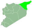
| Governorate | Al-Hasakah Governorate |
| District | Al-Malikiyah District |
| Nahiyah | Al-Malikiyah |
| Time zone | EET (UTC+3) |
| • Summer (DST) | EEST (UTC+2) |
Al-Khalidiyah (Arabic: الخالدية, Syriac: ܚܢܝܟ Khanik, Kurdish: Xanike), also known as Khanik (خانيك), is a village in the al-Hasakah Governorate in Northeastern Syria. The village lies on the Tigris Khabur opposite to the Iraqi village of Faysh Khabur. Just 3 km to the south of the tripoint of Iraq, Syria and Turkey. The village is also famous as the easternmost settlement of Syria. Khanik is inhabited by Assyrians belonging to the Chaldean Catholic Church and the Assyrian Church of the East. A number of Armenians also live in the village.[1]
See also
References
- ↑ "الكنيسة الكلدانية في قرية الخالدية خانيك". gazire.com. Retrieved 26 March 2012.
This article is issued from Wikipedia - version of the 9/28/2016. The text is available under the Creative Commons Attribution/Share Alike but additional terms may apply for the media files.