Khammam
| Khammam ఖమ్మం ﮐﮭﻤّﻢ Stambadri, Kambhadri Kambham mettu, Khammam mettu | |
|---|---|
| City | |
|
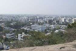
Khammam as seen from Narasimha Swamy Hill | |
 Khammam  Khammam Location in Telangana, India | |
| Coordinates: 17°15′N 80°10′E / 17.25°N 80.16°ECoordinates: 17°15′N 80°10′E / 17.25°N 80.16°E | |
| Country | India |
| State | Telangana |
| District | Khammam |
| Named for | Kamba |
| Government | |
| • Body | Khammam Municipal Corporation |
| • Mayor | Guguloth Papalal |
| • Deputy mayor | Battula Murali |
| • Municipal Commissioner | G.Venu Gopal |
| Area[1] | |
| • Total | 94.37 km2 (36.44 sq mi) |
| Area rank | 3rd (in state) |
| Elevation | 107 m (351 ft) |
| Population (2011)[1] | |
| • Total | 305,000 |
| • Rank |
150(India) 4th (Telangana) |
| • Density | 3,200/km2 (8,400/sq mi) |
| Languages | |
| • Official | Telugu, Urdu |
| Time zone | IST (UTC+5:30) |
| PIN | 507001/02/03 |
| Vehicle registration | TS–04[2] |
| Ethnicity | Indian |
| Website | Khammam Municipal Corporation |
Khammam is the city in Khammam district of the Indian state of Telangana. It is the headquarters of the Khammam district and Khammam mandal as well.[3] It is located about 193 kilometres (120 mi) east of the state capital, Hyderabad, and also it is located about 100 kilometres (62 mi) North of the Andhra Pradesh state capital, Amaravathi. The river Munneru flows on the western side of the town.[4] As of 2011 census of India, it had a population of 2,84,268, with an area of 94.37 km2. On 19 October 2012, the civic body of Khammam was upgraded to Municipal corporation, which includes 14 surrounding villages.[5]
Etymology
The name of Khammam was derived from the temple of Nrusimhadri and a local hill. In Urdu, a vertical rock is referred as Kamba and the name of Khammam was derived from it by undergoing several changes with names such as, Stamba Sikhari, Stambadri, Kambhadri, Kambham mettu, Khammam mettu.[3][6]
History
The present name of Khammam is said to have been derived from the name of the temple "Narsimhadri," later "Stamba Sikhari," and then it was called "Stambadhri," which has the ancient temple of Narasimha Swamy on its top. This temple is believed to have been existing since Treta Yuga. The vertical rock under the temple is known as 'KAMBA' which literally means pillar. The name of the town Khammam has been derived from "Kambam Mettu" to "Kammammet" or "Khammam Mettu" to the present "Khammam city." The district is also named as Khammam. On the other hand, the historical records show that the name was "Kammamet."[7][8][9][10][11][12]
The City is located on the banks of a river called Munneru which is a tributary of the Krishna River. Khammam district has a lot of historical importance in Telangana.
Khammam City, which was the seat of Taluk Administration, was part of the larger Warangal District, until 1 October 1953. Five taluks of the Warangal district viz., Khammam, Madhira, Yellandu, Burgampadu and Paloncha (now Kothagudem) were carved out and a new district Khammam with Khammam as District Headquarters. In 1959 Bhadrachalam Revenue Division consisting Bhadrachalam and Nuguru Venkatapuram Taluks of East Godawari district, which were on the other side of the river Godavari were merged into Khammam on grounds of geographical contiguity and administrative viability.
In 1973 a new taluk with Sathupalli as headquarters was formed carving out from Madhira and Kothagudem taluks. In the year 1976 four new taluks were formed viz., Tirumalayapalem, Sudimalla, Aswaraopeta and Khammam district was initially a part of larger Warangal District.
History of Khammam shows that it has produced a number of leaders who were part of the Freedom struggle, such as first generation Communist leaders Peravelli Venkata Ramanaiah, Pendyala Satyanarayana Rao, Sarvadevabhatla Ramanatham, K.L.Narsimha Rao, and Chirravuri Laxminarasaiah First Municipal Chairman of Khammam; Congress leaders Madapati Hanumantha Rao, Chepuri Nenkanna, Madapati Ramchander Rao, Sardar Jamalpuram Keshava Rao,Bommakanti Satyanarayana Rao, Hayagreeva Chary, and Nizam Rashtra Vimochanam Jalagam Vengala Rao, former Chief Minister of AP, Prof. K. Venkata Ramiah, Founder and Vice-Chancellor of KU.
Freedom movement
Some of the notable events in Khammam town during freedom struggle .
- 1931 – First Independence movement in Khammam proper
- 1935 – First Library established in Khammam town
- 1945 – 12th State Andhra Mahasabha meeting at Khammam organised by Pendyala Satya Narayana Rao as general secretary, Aahvana sangham. Elected Baddam Ellareddy as president and Pendyala Satya Narayana Rao as vice-president to 13th State Andhra Mahasabha in that meeting. The meeting was held on March 26,27 and 28th. Puchala-pally Sundaraiah participated in the meeting as guest.Nearly 40,000 people attended the meeting.
- 1946 – Mahathma Gandhi's visit to Khammam mett (Khammam town) on 5 August 1946
- 1947 August, 7 – Satyagraham at Madhira and Khammam by Jamalapuram Kesava Rao, Kurapati Venkata Raju, Vattikonda Ramakotaiah, Heeralal Moriya, Teegala Hanumantha Rao, Kolipaka Kishan Rao, Gella Keshava Rao, Yadavalli Venkateswara Sharma,Pullabhotla Venkateswarlu (Hyderabad congress present),Vutukuru Kamala (Freedom Fighter – Telangana Vimochana)
Geography
Topography
Khammam is located at 17°15′N 80°09′E / 17.25°N 80.15°E.[13] It has an average elevation of 107 metres (351 feet).
Climate
Climate for Khammam Average Weather in Khammam for January Sunlight 9 hours a day Coldest January temperature 12 °C Coldest daily temperature 16 °C Warmest daily temperature 28 °C Warmest January temperature 38 °C Discomfort* Moderate Morning Humidity 76% Evening Humidity 45% Rain in January 4 mm
Average Weather in Khammam for February Sunlight 10 hours a day Coldest February temperature 15 °C Coldest daily temperature 19 °C Warmest daily temperature 29 °C Warmest February temperature 40 °C Discomfort* Moderate Morning Humidity 67% Evening Humidity 39% Rain in February 9 mm Wet days for February 1 days
Khammam experiences typical Indian climatic conditions. Summer season is hot and the temperatures can climb rapidly during the day. Monsoon season brings certain amount of rainfall and the temperatures gradually reduce during this period. After the onset of the monsoon day temperatures are much lower and as the winter approaches they reduce further.
Summer season is from March and lasts till the end of May. During this time day temperatures are high and can reach 40 °C to 42 °C. Humidity is low as it is not located near the ocean. Conditions are generally dry during this period and the temperatures range from a minimum of 35 °C and can rise up to a maximum of 40 °C to 45 °C. Monsoon season brings much needed relief from the heat. Monsoon seasons are from the months of June to September. Temperatures average around 30 °C during this period. The place gets rain from the South West Monsoon. Some amount of rainfall can be experienced in the October as well. Winter season is from December to February. January is usually the coldest parts of the year. Temperatures range around 28 °C to 34 °C during this time.
- Winter: December To February
- Summer: March to June
- South West Monsoons – July to September
- North East Monsoons – October to November
Rain storms and cyclones are common in the region during the rainy season, which starts with the monsoons in early June. The cyclones could occur any time of the year, but commonly between August and November.
| Climate data for Khammam(1981–2010) | |||||||||||||
|---|---|---|---|---|---|---|---|---|---|---|---|---|---|
| Month | Jan | Feb | Mar | Apr | May | Jun | Jul | Aug | Sep | Oct | Nov | Dec | Year |
| Average high °C (°F) | 30.6 (87.1) |
32.4 (90.3) |
34.6 (94.3) |
36.6 (97.9) |
39.7 (103.5) |
38.3 (100.9) |
35.8 (96.4) |
35.0 (95) |
34.9 (94.8) |
33.0 (91.4) |
31.3 (88.3) |
30.6 (87.1) |
34.4 (93.9) |
| Average low °C (°F) | 20.2 (68.4) |
21.8 (71.2) |
24.0 (75.2) |
26.3 (79.3) |
28.0 (82.4) |
28.2 (82.8) |
26.9 (80.4) |
26.5 (79.7) |
26.0 (78.8) |
24.8 (76.6) |
22.5 (72.5) |
20.6 (69.1) |
24.7 (76.5) |
| Average precipitation mm (inches) | 18.7 (0.736) |
4.1 (0.161) |
18.3 (0.72) |
12.9 (0.508) |
68.5 (2.697) |
61.0 (2.402) |
108.3 (4.264) |
115.5 (4.547) |
148.0 (5.827) |
247.0 (9.724) |
175.1 (6.894) |
31.5 (1.24) |
1,009 (39.724) |
| Average precipitation days | 0.8 | 0.9 | 0.5 | 0.5 | 2.4 | 3.6 | 6.5 | 7.3 | 6.8 | 8.8 | 5.8 | 1.8 | 45.6 |
| Source: India Meteorological Department[14] | |||||||||||||
During the 2015 India heat wave, Khammam experienced a maximum temperature of 48 °C (118 °F).[15][16]
Floods
Khammam has been receiving higher annual rainfall than the rest of state. The annual rain fall is 175 centimetres (69 in) during the monsoon season. Khammam was also affected by the floods of Munneru, the tributary of Krishna River. In 2007, the floods stuck by the River drowned the Bokkalagadda with the heavy 3-day rain. Again in 2009, floods stuck and drowned the area again. Proposal was also there for the construction of barricade here.Food Corporation of India storage centres in Khammam releases food for the flood victims regularly.
Demographics
As of 2011 census, the city had a population of 184,252. The total population constitute, 91,019 males and 93,233 females —a sex ratio of 1025 females per 1000 males. 17,131 children are in the age group of 0–6 years, of which 8,876 are boys and 8,255 are girls —a ratio of 1075 per 1000. The average literacy rate stands at 81.70% with 136,532 literates, significantly higher than the state average of 67.41%.[17][18]
Governance
Civic administration
Khammam Municipal Corporation is the civic body of the city.
Khammam is one of the Historical City of Telangana, having nearly 1000 years of traceable History. It is the headquarters town of the District Khammam and emerged as Municipal Corporation, with an extent of 94.37 km2. The town was constituted into a Municipality on 24 March 1942 and upgraded as special grade Municipality in the year 2001.. Administratively Khammam is divided into 11 revenue wards with 41 Election wards. On October 19, 2012 Khammam municipality has been announced as Municipal Corporation, adding 9 GramPanchayats around it which developed in business with the town.Presently Khammam has 20 revenues wards and 50 election divisions.
Culture
Bhakta Ramadasu Kala Kshetram,[19] has been a prestigious National theatre, constructed by the Government of Andhra Pradesh in the name of Sri. Bhakta Ramadasu ( Kancherla Gopanna )[20] was devotee of Sri Rama and composer of carnatic music.
Cityscape
Landmarks
Khammam Fort, constructed in 950 AD by the Kakatiya Dynasty, is on a hill overlooking the town. Lakaram lake, Khammam city is another tourist attraction.[21] Apart from these there are many places surrounding the town namely Bhadrachalam, Parnasala, Nelakondapalli, Kusumanchi etc.
Transport

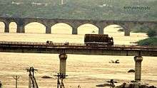
The city is connected to major cities and towns by means of road and railways. National and state highways that pass through the city are National Highway 365A, State Highway 3 and 42. TSRTC operates buses to various destinations from Khammam bus station of the city.[22] Khammam railway station provides rail connectivity to the city, located on the Kazipet–Vijayawada section of New Delhi-Chennai main line. It is administered under Secunderabad railway division of the South Central Railway zone.
Education
There are various pharmacy colleges, and MBA, MCA, engineering colleges like Swarna Bharathi Institute of Science and Technology around Khammam city. Mamata Medical College which is also a teaching hospital located in the city.SR & BGNR Degree and KMDC Degree & PG College also conducts archaeological research on megalithic sites. For competitive exams like groups, police, teacher jobs Right Choice IAS academy is the famous coaching centre in entire khammam dist.[23][24]
Media
The major Telugu newspapers in city are Namaste Telangana, [Sakshi (newspaper)|Sakshi]], Eenadu, Andhra Bhoomi, Andhra Prabha, Vaartha, Suryaa, Prajasakti and Vishalandra. The major English newspapers in the city are The Hindu, The Times of India, Deccan Chronicle, The Hindu Business Line, The New Indian Express and The Hans India. Electronic Media include HMTV, ETV and Sakshi.
Sports
- Sardar Patel Stadium[25] – A stadium with all amenities including sports complex, indoor stadium, swimming pool, cricket net, skating rink, volleyball, basketball and tennis courts. There is a running track around the football pitch.
- Pavilion Grounds By Khammam Municipal Corporation
- SR & BGNR Grounds
References
- 1 2 "Basic Information". Official website of Khammam Municipal Corporation. Retrieved 18 February 2016.
- ↑ "District Codes". Government of Telangana Transport Department. Retrieved 4 September 2014.
- 1 2 "Khammam". Telangana state portal. Retrieved 15 June 2015.
- ↑ "Krishna District Mandals" (PDF). Census of India. p. 145. Retrieved 21 February 2016.
- ↑ "Khammam Municipality upgraded". The Hindu. 2012-10-20. Retrieved 2013-11-17.
- ↑ Prof K Vijaya Babu; Jayaprakashnarayana Gade (2014). Tourism in India. Zenon Academic Publishing. p. 126. ISBN 978-81-926819-7-9. Retrieved 21 February 2016.
- ↑ A Descriptive and Historical Account of the Godavery District in the Presidencyof Madras, H. Morris, 1878, London, p. 216
- ↑ A manual of the Kistna district in the presidency of Madras, Gordon Mackenzie, 1883, Madras, p. 25, 80
- ↑ Buddhist remains in Āndhra and the history of Āndhra between 224 & 610 A.D., K. R. Subramanian, p. 149
- ↑ A Handbook for India, Part I, Madras, John Murray, 1859, London
- ↑ The Geography of India, J. Burgess, 1871, London, p. 48
- ↑ The Church Missionary Intelligencer,Volume 2,1866, London, p. 73
- ↑ "redirect to /world/IN/02/Khammam.html".
- ↑ "Khammam Climatological Table Period: 1981–2010". India Meteorological Department. Retrieved 31 January 2016.
- ↑ "Heatwave sweeps across India, 335 people dead". The Times of India. 24 May 2015. Retrieved 24 May 2015.
- ↑ "Hundreds Are Dying in a Blistering Heat Wave Sweeping Across India". Time. 25 May 2015. Retrieved 25 May 2015.
- ↑ "Provisional Population Totals, Census of India 2011 Cities having population 1 lakh and above" (PDF). The Registrar General & Census Commissioner, India. Retrieved 7 July 2014.
- ↑ "Literacy of AP (Census 2011)" (PDF). Official Portal of Andhra Pradesh Government. p. 43. Archived from the original (PDF) on 14 July 2014. Retrieved 5 September 2014.
- ↑ "Bhaktha Ramdas Kalakeshthram,Photo-India". Ugo.cn. Retrieved 2013-11-17.
- ↑ Kancherla Gopanna
- ↑ "Lakaram lake". Andhra Pradesh Tourism. Archived from the original on 30 October 2013.
- ↑ "Bus Stations". TSRTC. Retrieved 20 May 2016.
- ↑ Staff Reporter. "Brochure on megalithic sites in Khammam". The Hindu.
- ↑ P. Sridhar. "Impetus for heritage conservation mission". The Hindu.
- ↑ "Welcome to Sports Authority of Andhra Pradesh (S A A P)". Saap.in. Retrieved 2013-11-17.
External links
| Wikivoyage has a travel guide for Khammam. |
| District headquarters | |
|---|---|
| Revenue divisions | |
| Mandals | |
| Cities | |
| Towns |
|
| Census Towns |
|