Key West Historic District
|
Key West Historic District | |
|
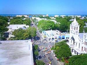
Overview of part of the Key West Historic District from atop the La Concha | |
  | |
| Location | Key West, Florida |
|---|---|
| Coordinates | 24°33′13″N 81°47′43″W / 24.55361°N 81.79528°WCoordinates: 24°33′13″N 81°47′43″W / 24.55361°N 81.79528°W |
| Area | 4,000 acres (1,600 ha) |
| Built | 1822 |
| NRHP Reference # |
71000245 (original) 83001430 (increase) |
| Significant dates | |
| Added to NRHP | March 11, 1971 |
| Boundary increase | February 24, 1983 |
The Key West Historic District (also known as Old Town of the City of Key West) is a U.S. historic district (designated as such on March 11, 1971) located in Key West, Florida. It encompasses approximately 4000 acres (16 km²), bounded by White, Angela, Windsor, Passover, Thomas and Whitehead Streets, and the Gulf of Mexico. It contains 187 historic buildings and one structure.
On February 24, 1983, the district was expanded to 5400 acres (22 km²), bounded by Emma, Whitehead, White, and South Streets, Mallory Square, and the Atlantic Ocean, to contain 2485 historic buildings and four structures.
Old Town is the name given to the historic district of the island of Key West, Florida. It is roughly the western half of the island. It is also where the central business district and majority of tourist attractions are located.
Points of interest
- Key West Aquarium
- The Armory
- Audubon House and Tropical Gardens
- Basilica of St. Mary Star of the Sea
- Captain Tony's Saloon
- Key West Cemetery
- U.S. Coast Guard Headquarters, Key West Station
- Ernest Hemingway House
- Key West Heritage House Museum and Robert Frost Cottage
- Key West Light
- Mallory Square
- Mel Fisher Maritime Heritage Museum
- Birthplace of Pan-Am
- Dr. Joseph Y. Porter House
- Key West Museum of Art and History
- Key West Shipwreck Historeum Museum
- Sloppy Joe's
- Richard Peacon House
- Southernmost House
- Thompson Fish House, Turtle Cannery and Kraals
- Harry S. Truman Little White House
- Western Union (schooner)
Gallery
| Wikimedia Commons has media related to Key West Historic District. |
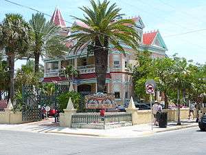 Southernmost House, a victorian-style mansion in Old Town Key West.
 Former Key West Customshouse, now the Museum of Art & History in Old Town Key West.
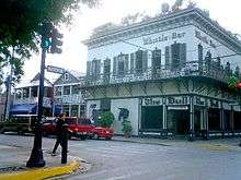 The Bull & Whistle bars, in Old Town Key West.
External links
- Florida's Office of Cultural and Historical Programs - Monroe County
- National Register of Historic Places - Monroe County listings"