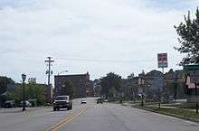
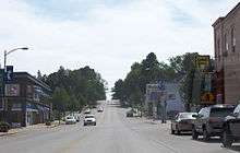
Kewaunee, Wisconsin
| Kewaunee, Wisconsin | |
|---|---|
| City | |
|
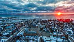
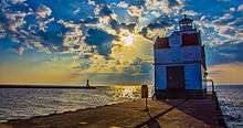
Looking east to the Kewaunee harbor and Lake Michigan | |
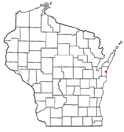 Location of Kewaunee, Wisconsin | |
| Coordinates: 44°27′32″N 87°30′34″W / 44.45889°N 87.50944°WCoordinates: 44°27′32″N 87°30′34″W / 44.45889°N 87.50944°W | |
| Country | United States |
| State | Wisconsin |
| County | Kewaunee |
| Area[1] | |
| • Total | 4.29 sq mi (11.11 km2) |
| • Land | 3.54 sq mi (9.17 km2) |
| • Water | 0.75 sq mi (1.94 km2) |
| Elevation[2] | 610 ft (186 m) |
| Population (2010)[3] | |
| • Total | 2,952 |
| • Estimate (2012[4]) | 2,942 |
| • Density | 833.9/sq mi (322.0/km2) |
| Time zone | Central (CST) (UTC-6) |
| • Summer (DST) | CDT (UTC-5) |
| Area code(s) | 920 |
| FIPS code | 55-39350[5] |
| GNIS feature ID | 1567445[2] |
| Website |
cityofkewaunee |
Kewaunee is a city in Kewaunee County, Wisconsin, United States. The population was 2,952 at the 2010 census. Located on the northwestern shore of Lake Michigan, the city is the county seat of Kewaunee County.[6]
Kewaunee is part of the Green Bay Metropolitan Statistical Area.
Geography
Kewaunee is located at 44°27′32″N 87°30′34″W / 44.45889°N 87.50944°W (44.458758, -87.509496).[7]
According to the United States Census Bureau, the city has a total area of 4.29 square miles (11.11 km2), of which, 3.54 square miles (9.17 km2) is land and 0.75 square miles (1.94 km2) is water.[1]
Highways
-
 WIS 42 Northbound travels to Algoma, Wisconsin. South it continues into Two Rivers and Manitowoc,Wisconsin.
 -
 WIS 29 connects with Green Bay, Wisconsin westbound.
Demographics
| Historical population | |||
|---|---|---|---|
| Census | Pop. | %± | |
| 1880 | 1,050 | — | |
| 1890 | 1,216 | 15.8% | |
| 1900 | 1,773 | 45.8% | |
| 1910 | 1,839 | 3.7% | |
| 1920 | 1,865 | 1.4% | |
| 1930 | 2,409 | 29.2% | |
| 1940 | 2,533 | 5.1% | |
| 1950 | 2,583 | 2.0% | |
| 1960 | 2,772 | 7.3% | |
| 1970 | 2,901 | 4.7% | |
| 1980 | 2,801 | −3.4% | |
| 1990 | 2,750 | −1.8% | |
| 2000 | 2,806 | 2.0% | |
| 2010 | 2,952 | 5.2% | |
| Est. 2015 | 2,876 | [8] | −2.6% |
2010 census
As of the census[3] of 2010, there were 2,952 people, 1,278 households, and 733 families residing in the city. The population density was 833.9 inhabitants per square mile (322.0/km2). There were 1,462 housing units at an average density of 413.0 per square mile (159.5/km2). The racial makeup of the city was 96.6% White, 0.3% African American, 0.3% Native American, 0.4% Asian, 1.1% from other races, and 1.1% from two or more races. Hispanic or Latino of any race were 1.8% of the population.
There were 1,278 households of which 25.3% had children under the age of 18 living with them, 45.9% were married couples living together, 7.7% had a female householder with no husband present, 3.8% had a male householder with no wife present, and 42.6% were non-families. 36.5% of all households were made up of individuals and 16.6% had someone living alone who was 65 years of age or older. The average household size was 2.24 and the average family size was 2.81.
The median age in the city was 45.8 years. 19.8% of residents were under the age of 18; 6.7% were between the ages of 18 and 24; 22.4% were from 25 to 44; 28.5% were from 45 to 64; and 22.6% were 65 years of age or older. The gender makeup of the city was 50.4% male and 49.6% female.
2000 census
As of the census[5] of 2000, there were 2,806 people, 1,149 households, and 736 families residing in the city. The population density was 807.7 people per square mile (312.2/km²). There were 1,237 housing units at an average density of 356.1 per square mile (137.6/km²). The racial makeup of the city was 98.25% White, 0.36% African American, 0.39% Native American, 0.21% Asian, 0.14% from other races, and 0.64% from two or more races. Hispanic or Latino of any race were 0.57% of the population.[5]
There were 1,149 households out of which 29.5% had children under the age of 18 living with them, 53.1% were married couples living together, 7.7% had a female householder with no husband present, and 35.9% were non-families. 32.6% of all households were made up of individuals and 17.6% had someone living alone who was 65 years of age or older. The average household size was 2.34 and the average family size was 2.97.[5]
In the city the population was spread out with 23.3% under the age of 18, 7.7% from 18 to 24, 25.5% from 25 to 44, 21.7% from 45 to 64, and 21.8% who were 65 years of age or older. The median age was 41 years. For every 100 females there were 95.8 males. For every 100 females age 18 and over, there were 91.4 males.[5]
The median income for a household in the city was $36,420, and the median income for a family was $45,643. Males had a median income of $32,292 versus $20,544 for females. The per capita income for the city was $17,384. About 11.2% of families and 10.5% of the population were below the poverty line, including 8.0% of those under age 18 and 18.0% of those age 65 or over.[5]
Economy
- The Kewaunee Nuclear Generating Station is in Carlton in Kewaunee County.
Attractions
Notable people
- Jerry Augustine, MLB player, head coach of the University of Wisconsin-Milwaukee Panthers baseball team
- Henry Baetz, Treasurer of Wisconsin
- Colin Cochart, NFL player
- Art Fiala, the last surviving World War I veteran from Wisconsin
- George Grimmer, Wisconsin State Senator
- Terry Jorgensen, MLB player
- John C. Karel, Wisconsin State Assemblyman
- Thomas F. Konop, U.S. Representative
- Stan Kuick, NFL player
- Ransom Asa Moore, professor
- Robert E. Minahan, Mayor of Green Bay, Wisconsin
- Jack Novak, NFL player
- Alvin E. O'Konski, U.S. Representative
- John Milton Read, Wisconsin legislator and newspaper editor[10]
- Dena A. Smith, Wisconsin State Treasurer
- Joseph Stika, U.S. Coast Guard Vice Admiral
References
- 1 2 "US Gazetteer files 2010". United States Census Bureau. Retrieved 2012-11-18.
- 1 2 "US Board on Geographic Names". United States Geological Survey. 2007-10-25. Retrieved 2008-01-31.
- 1 2 "American FactFinder". United States Census Bureau. Retrieved 2012-11-18.
- ↑ "Population Estimates". United States Census Bureau. Retrieved 2013-06-24.
- 1 2 3 4 5 6 "American FactFinder". United States Census Bureau. Retrieved 2008-01-31.
- ↑ "Find a County". National Association of Counties. Retrieved 2011-06-07.
- ↑ "US Gazetteer files: 2010, 2000, and 1990". United States Census Bureau. 2011-02-12. Retrieved 2011-04-23.
- ↑ "Annual Estimates of the Resident Population for Incorporated Places: April 1, 2010 to July 1, 2015". Retrieved July 2, 2016.
- ↑ "Census of Population and Housing". Census.gov. Retrieved June 4, 2015.
- ↑ 'Wisconsin Blue Book 1874,' Biographical Sketch of John Milton Read, pg. 488
External links
| Wikimedia Commons has media related to Kewaunee, Wisconsin. |
Municipalities and communities of Kewaunee County, Wisconsin, United States | ||
|---|---|---|
| Cities | 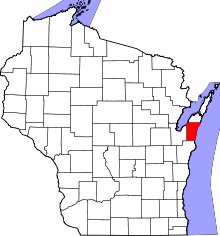 | |
| Villages | ||
| Towns | ||
| CDP | ||
| Unincorporated communities | ||
| Footnotes | ‡This populated place also has portions in an adjacent county or counties | |