Kerma Culture
| Kingdom of Kerma | ||||||||
| ||||||||
| Capital | Kerma | |||||||
| Government | Monarchy | |||||||
| Nedjeh | ||||||||
| History | ||||||||
| • | Established | c. 2500 BCE | ||||||
| • | Disestablished | c. 1500 BCE | ||||||
| ||||||||
The Kerma Culture was an early civilization that flourished from around 2500 BCE to about 1500 BCE in Nubia, in Upper Egypt and northern Sudan, centered at Kerma, Sudan.[1] It seems to have been one of a number of Nile valley states during the Middle Kingdom of Egypt. In the Kingdom of Kerma's latest phase, lasting from about 1700–1500 BCE, it absorbed the Sudanese kingdom of Sai and became a sizable, populous empire rivaling Egypt. Around 1500 BCE, it was absorbed into the New Kingdom of Egypt, but rebellions continued for centuries. By the eleventh century BCE, the more Egyptianized Kingdom of Kush emerged, possibly from Kerma, and regained the region's independence from Egypt.
Site
The primary site of Kerma that forms the heart of the Kingdom of Kerma includes both an extensive town and a cemetery consisting of large tumuli. The level of affluence at the site demonstrated the power of the Kingdom of Kerma, especially during the Second Intermediate Period when the Kermans threatened the southern borders of Egypt.[2]
Ecopolitical structure
Until recently, the Kerma civilisation was known only from the townsite and cemeteries of its metropolitan centre and smaller sites in Kerma, Sudan. However, recent survey and excavation work has identified many new sites south of Kerma, many located on channels of the Nile, now dry, which lay to the east of the modern course of the river. This pattern of settlement indicates a substantial population and for the first time provides us with some sort of context in which we can place Kerma itself. Survey work in advance of the Merowe Dam at the Fourth Cataract has confirmed the presence of Kerma sites at least as far upriver as the Abu Hamad/Mograt Island area.[3]
Kerma was evidently a sizable political entity - Egyptian records speak of its rich and populous agricultural regions. Unlike Egypt, Kerma seems to have been highly centralized. It controlled the 1st to 4th Cataracts, which meant its domain was as extensive as ancient Egypt.[4]
Numerous village communities scattered alongside fields of crops made up the bulk of the realm, but there also seems to have been districts wherein pastoralism (goat, sheep and cattle) and gold processing were important industries.[5] Certain Kerma towns served to centralize agricultural products and direct trade. Analysis of the skulls of thousands of cattle interred in royal Kerma tombs suggest that stock were sometimes brought vast distances, from far districts, presumably as a type of tribute from rural communities on the death of Kerma's monarchs. This parallels the importance of cattle as royal property in other parts of Africa at later times.
Only the centres of Kerma and Sai seem to have had contained sizable urban populations. Possibly further excavations will reveal other regional centres. At Kerma and Sai, there is much evidence of wealthy elites, and a class of dignitaries who monitored trade in merchandise arriving from far-off lands, and who supervised shipments dispatched from administrative buildings. Evidently, Kerma played an important intermediary role in the trade of luxury items from the Central African interior to Egypt.[6]
Place in ancient history

During the First Intermediate Period, the Egyptian presence in Lower Nubia ceased. When at the beginning of the New Kingdom, Egyptian sources again mentioned the region of Kerma, they reported Kerma as being in control of both Upper and Lower Nubia.
The long history of Egyptian military activity in Lower Nubia may indicate that Kerma was perceived as a threat to Pharaonic Egypt at varying times. Principle Egyptian fortifications were built in the middle Nile Valley during the Middle Kingdom.[7] These were to secure the Upper Egyptian border against raids from Kerma, and more than likely and to protect the valuable trade routes between the two regions.[3] Both during the Middle and New Kingdoms, the resources Kerma possessed – gold, cattle, milk products, ebony, incense, ivory, etc. – were much coveted by Egypt. Its army were built around archers. [8]
During its zenith, Kerma formed a partnership with the Hyksos and tried to crush Egypt. Discoveries in 2003 at the Governor of El Kab's Tomb (near Thebes) show that Kerma invaded deep into Egypt between 1575 and 1550 BC. It is believed that this was one of Egypt's most humiliating defeats, which later pharaohs erased from the official historic records. Many royal statues and monuments were looted from Egypt and removed to Kerma, apparently as a gesture of triumph by Kerma's ruler.[9]

Under Tuthmosis I, Egypt made several campaigns south.[10] This eventually resulted in their annexation of Nubia (Kerma/ Kush) c.1504 bc. After the conquest, Kerma culture was increasingly 'Egyptianized' yet rebellions continued for 220 years (till c.1300 BCE). During the New Kingdom, Kerma/Kush nevertheless became a key province of the Egyptian Empire - economically, politically and spiritually. Indeed, major Pharonic ceremonies were held at Jebel Barkal near Napata,[11] and the royal lineages of the two regions seem to have intermarried.
The extent of cultural/political continuity between the Kingdom of Kerma and the chronologically succeeding Kingdom of Kush is difficult to determine. The latter polity began to emerge around 1000 BCE, around 500 years after the end of the Kingdom of Kerma. Initially, the Kushite kings continued to use Kerma for royal burials and special ceremonies, suggesting some connection. Moreover, the layout of royal funerary compounds in both Kerma and Napata (the Kush capital) are similarly designed. Caches of statues of Kush's pharaohs have also been discovered at Kerma, suggesting that the Napatan rulers recognized a historic link between their capital and Kerma.
Language
According to Peter Behrens (1981) and Marianne Bechaus-Gerst (2000), linguistic evidence indicates that the Kerma peoples spoke Afro-Asiatic languages of the Cushitic branch.[12][13] The Nilo-Saharan Nobiin language today contains a number of key pastoralism related loanwords that are of proto-Highland East Cushitic origin, including the terms for sheep/goatskin, hen/cock, livestock enclosure, butter and milk. This in turn suggests that the Kerma population — which, along with the C-Group Culture, inhabited the Nile Valley immediately before the arrival of the first Nubian speakers — spoke Afro-Asiatic languages.[12]
Archaeology
20th century archaeology

When Kerma was first excavated in the 1920s, George Andrew Reisner believed that it originally served as the base for or was a fort of an Egyptian governor, and that these Egyptian rulers evolved into the independent monarchs of Kerma. Reisner's interpretation was predicated on the presence of inscribed Egyptian statues in the large burials, which he thought belonged to those named individuals.
In later decades, scholars moved to the view that Kerma was a trading outpost of the Egyptians, being too small and far away from the known borders of ancient Egypt to be more directly linked to it.
However, in the past ten to fifteen years, excavations have revealed that Kerma city was much larger and more complex than previously assumed. It was also realized that the material culture and burial practices here are overwhelmingly of local Kerman origin rather than Egyptian.
21st century archaeology
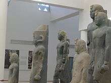
In 2003, archaeologist Charles Bonnet heading a team of Swiss archaeologists excavating near Kerma discovered a cache of monumental black granite statues of the Pharaohs of the Twenty-fifth Dynasty of Egypt. Among the sculptures were ones belonging to the dynasty's last two pharaohs, Taharqa and Tanoutamon, whose statues are described as "masterpieces that rank among the greatest in art history."[14]
References
- ↑ Hafsaas-Tsakos, Henriette (2009). "The Kingdom of Kush: An African Centre on the Periphery of the Bronze Age World System". Norwegian Archaeological Review. 42 (1): 50–70. doi:10.1080/00293650902978590.
- ↑ Hafsaas-Tsakos, H. 2010: Between Egypt and Kush, pp. 393-394.
- 1 2 Edwards, David N. "Archaeology in Sudan". Retrieved 21 March 2012.
- ↑ Smith, Stuart Tyson. "Nubia: History". Retrieved 21 March 2012.
- ↑ Staff (19 June 2007). "Gold Processing Center Discovered in the Ancient Kingdom of Kush". Culture Kiosque.
- ↑ Bonnet, Charles (2003). The Nubian Pharaohs. New York: The American University in Cairo Press. pp. 16–26. ISBN 978-977-416-010-3.
- ↑ De Mola, Paul J. "Interrelations of Kerma and Pharaonic Egypt". Ancient History Encyclopedia: http://www.ancient.eu/article/487/.
- ↑ "Kerma Culture". The Oriental Institute of The University of Chicago. The Oriental Institute of The University of Chicago.
- ↑ "Tomb Reveals Ancient Egypt's Humiliating Secrets". Daily Times. 29 July 2003.
- ↑ De Mola, Paul J. "Interrelations of Kerma and Pharaonic Egypt". Ancient History Encyclopedia: http://www.ancient.eu/article/487/
- ↑ "Jebal Barkal: History and Archaeology of Ancient Napata". Retrieved 21 March 2012.
- 1 2 Marianne Bechaus-Gerst, Roger Blench, Kevin MacDonald (ed.) (2014). The Origins and Development of African Livestock: Archaeology, Genetics, Linguistics and Ethnography - "Linguistic evidence for the prehistory of livestock in Sudan" (2000). Routledge. p. 453. ISBN 1135434166. Retrieved 15 September 2014.
- ↑ Behrens, Peter (1986). Libya Antiqua: Report and Papers of the Symposium Organized by Unesco in Paris, 16 to 18 January 1984 - "Language and migrations of the early Saharan cattle herders: the formation of the Berber branch". Unesco. p. 30. ISBN 9231023764. Retrieved 14 September 2014.
- ↑ Digging into Africa's past
Further reading
| Wikimedia Commons has media related to Kerma. |
- Reisner, G. A. 1923, Excavations at Kerma I-III/IV-V. Harvard African Studies Volume V. Peabody Museum of Harvard University, Cambridge Mass.
- Hafsaas-Tsakos, H. 2009, The Kingdom of Kush: An African centre on the periphery of the Bronze Age World System. Norwegian Archaeological Review, 42/1: 50-70.
- Bonnet, Charles, et al., 2005, Des Pharaohs venus d'Afrique : La cachette de Kerma. Citadelles & Mazenod.
- Bonnet, Charles, 1986, Kerma, Territoire et Métropole, Institut Français d’Archaéologie Orientale du Caire.
- Kendall, Timothy 1997. Kerma and the Kingdom of Kush. National Museum of African Art, Smithsonian Inst. Washington D.C.
- Bechaus-Gerst, Marianne, 2000, The Origins and Development of African Livestock: Archaeology, Genetics, Linguistics and Ethnography, "Linguistic evidence for the prehistory of livestock in Sudan". Routledge.
External links
- Swiss Archeological Mission: Kerma website - Official website of the Swiss archeological mission to Sudan
Coordinates: 19°36′03″N 30°24′35″E / 19.600802°N 30.409731°E