Keresley
Keresley is a village and civil parish in the City of Coventry, West Midlands, England, about 5 miles (8 km) north of Coventry city centre. According to the 2001 census, the parish had a population of 791 falling to 713 at the 2011 Census.[1] Keresley and Keresley End are two separate areas; Keresley is in Coventry, while the slightly more rural Keresley End, also known as Keresley village or Keresley Newlands, is in Warwickshire, with the exception of Thompsons Road in the village, which comes under the Coventry boundary. The village features two grocers shops, two bus stops, a beauty salon, primary school, doctors surgery, a fish and chip shop, a small church, a post office, library, park, garden centre and community centre.
Location
Keresley is located in the north west of the city. Keresley lies within the Bablake and it is bounded by the Woodlands, Whoberley, Sherbourne, Radford and Holbrook wards.[2]
History
For most of its history, Keresley was a combination of two further villages: Keresley Green was the most northerly and first to exist, but it was Keresley Heath to the south which was developed the most with the building of schools and the church of St. Thomas. However, in 1911 the construction of Coventry Colliery by the Warwickshire Coal Company near to Keresley Green brought the focus of development back to that area.[3] It was not until 1974 that the two parts of Keresley lost their separate identities and became united. The closure of the colliery followed in 1991.[4]
Keresley parish is largely rural and contains some beautiful ancient woodland. Coventry City Council's wildlife surveys which include Keresley parish, have classified much of the area as an "A" grade - "An area of very high natural history value, containing several varied habitats and a wide diversity of plants and animals". The area has a lot of footpaths which make it accessible to the public and is probably one of the few areas of Coventry where you can hear skylarks. Despite this Coventry City Council propose the area can be developed as an "Eco" suburb with 3000 homes, and a separate estate of new properties is currently being built, as of January 2010.[5]
Etymology
The etymology of the word Keresley suggests that it is Saxon in origin, meaning that the name could originate from the 7th century, although the village was not cited in the Domesday Book of 1086.
The -ley suffix is shared by many villages in the country, and means a clearing in the woods. This means that Keresley was clearing in the Forest of Arden. And the Keres- prefix is thought to either be a corruption of the Saxon word for cress or someone's name, meaning together either: The cress clearing, or 'Mr' Cress's Clearing.
Parish Church
The Church of England parish church of Saint Thomas is just off the Tamworth Road (B4098). It was designed by the Gothic Revival architect Benjamin Ferrey in the Early English style[6] and built in 1844-45.[7] The bell tower has a ring of six bells.[8] St. Thomas's is a Grade II* listed building.
-

St Thomas' Church, Keresley.
-
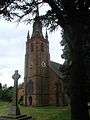
The tower of St Thomas' Church.
Public services and local amenities
Coventry City Council is the local government body of the City of Coventry. The city is divided up into 18 Wards each with three councillors.[9]
Coventry forms part of the West Midlands Police force area.[10] The neighbourhood policing team for Keresley, Coundon and Allesley are the Bablake neighbourhood team.[11]
Notable residents
The actor Clive Owen and the cybernetics professor Kevin Warwick were born in Keresley. So was novelist Graham Joyce. Also from Keresley is Roddy 'Radiation' Byers guitarist of 1980s ska band The Specials.
Apple rain
On the evening of Monday 12 December 2011 hundreds of apples reportedly fell from the sky over the junction between Kelmscote Road and Keresley Road, in Keresley, Coventry. Several witnesses reported that hundreds of apples seemingly fell out of the sky landing on the ground, and several cars, below. This incident received both local and national media coverage and, although it drew comment by the Met Office, it still remains unexplained.[12][13][14][15][16]
References
- ↑ "Civil Parish population 2011". Neighbourhood Statistics. Office for National Statistics. Retrieved 16 December 2015.
- ↑ "Bablake Ward". Coventry City Council. Retrieved 10 February 2014.
- ↑ Institution of Mining Engineers (1915). The Mining Engineer. Institution of Mining Engineers. p. 799.
- ↑ "St Thomas' Church Keresley". Retrieved 10 February 2014.
- ↑ "Keresley Eco-Suburb". Keresley Villages. Retrieved 10 February 2014.
- ↑ Historic England. "Details from image database (218586)". Images of England.
- ↑ Pevsner & Wedgwood, 1966, p. 326
- ↑ Coventry Diocesan Guild of Church Bellringers: Tower Directory
- ↑ "Coventry City Council". Retrieved 10 February 2014.
- ↑ "West Midlands Police - About Us". Retrieved 10 February 2014.
- ↑ "Bablake Neighbourhood Policing Team". Retrieved 10 February 2014.
- ↑ http://www.coventrytelegraph.net/news/coventry-news/2011/12/14/mystery-of-apples-falling-from-sky-in-keresley-92746-29949102/
- ↑ http://www.huffingtonpost.co.uk/2011/12/14/apples-fall-from-the-sky-coventry_n_1148287.html?ref=uk
- ↑ Dolan, Andy (14 December 2011). "It's raining apples! Traffic grinds to a halt as 'mini tornado' dumps a hail of fruit". Daily Mail. London.
- ↑ http://www.dailystar.co.uk/news/view/225654/Drivers-stopped-by-freak-fruit-shower/
- ↑ "Keresley residents mystified by apple shower". BBC News. 15 December 2011. Retrieved 10 February 2014.
Sources
- Pevsner, Nikolaus; Wedgwood, Alexandra (1966). The Buildings of England: Warwickshire. Harmondsworth: Penguin Books. ISBN 0-14-071031-0.
External links
Coordinates: 52°26′N 1°32′W / 52.433°N 1.533°W