Kenora District
| Kenora District | |
|---|---|
| District | |
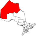
 Location of Kenora District in Ontario | |
| Coordinates: 49°46′N 94°29′W / 49.767°N 94.483°WCoordinates: 49°46′N 94°29′W / 49.767°N 94.483°W | |
| Country |
|
| Province |
|
| Region | Northwestern Ontario |
| Created | 1907 |
| Government | |
| • MPs | Bob Nault (LPC), Charlie Angus (NDP) |
| • MPPs | Sarah Campbell (NDP), Gilles Bisson (NDP) |
| Area[1] | |
| • Land | 407,213.01 km2 (157,225.82 sq mi) |
| Highest elevation | 505 m (1,657 ft) |
| Lowest elevation | 0 m (0 ft) |
| Population (2011)[1] | |
| • Total | 57,607 |
| • Density | 0.1/km2 (0.3/sq mi) |
| Time zones | Central (CST) (UTC-6) |
| Eastern (EST) (UTC-5) | |
| • Summer (DST) | Central Daylight (CDT) (UTC-5) |
| Eastern Daylight (EDT) (UTC-4) | |
| Postal Code FSA | P0V, P0X, P0Y, P8N, P8T, P9N |
| Area code(s) | 807 |
| Largest communities[2] |
Kenora (15,177) Dryden (8,195) Sioux Lookout (5,183) |
| Website | Kenora District Services Board |
Kenora District is a district and census division in Northwestern Ontario, Canada. It was created in 1907 from parts of Rainy River District. It is geographically the largest division in that province; at 407,213.01 square kilometres (157,225.82 sq mi), it comprises almost 38 percent of the province's land area, making it larger than Newfoundland and Labrador, and slightly smaller than Sweden.
Kenora District also has the lowest population density of any of Ontario's census divisions, and it ranks 40th out of 49 by population.
The district seat is the City of Kenora.
The northern part, north of the Albany River and known sometimes as the Patricia Portion, became part of Ontario in 1912. It was originally designated as the separate Patricia District, but was added to the Kenora District in 1937.[3]
Politics
As with the other districts of Northern Ontario, Kenora District has no equivalent to the county or regional municipality level of government that exists in Southern Ontario. All government services in the district are instead provided by the local municipalities, by local services boards in some unincorporated communities, or directly by the provincial government.
Geography
The climate is very harsh because of the influence of the cold waters of Hudson and James Bays: most of the region is taiga characterized by discontinuous permafrost, but on the extreme northern coast there are – remarkably for a latitude of only 54°N – patches of true Arctic tundra and continuous permafrost. This is the southernmost point in the Northern Hemisphere reached by the circumpolar line of continuous permafrost on any continent.
The Kenora District is so geographically large that it shares a border with both the contiguous United States (the boundary between it and the Northwest Angle is located in the Lake of the Woods) and the Canadian Arctic waters (Hudson Bay), the only district in Canada to do so.
The Kenora District contains the Sturgeon Lake Caldera, which is one of the world's best preserved Neoarchean caldera complexes and is some 2.7 billion years old.[4]
Subdivisions
Cities
Towns

Townships
First Nations reserves
First Nations settlements
- Frenchman's Head
- Kejick Bay
- Lansdowne House
- MacDowell Lake
- Muskrat Dam
- Peawanuck
- Slate Falls
- Summer Beaver
- Webequie
- Whitefish Bay
Unorganized areas
- Kenora, Unorganized (including the local services boards of Greater Oxdrift, Melgund, Minaki, Redditt, Round Lake, and Wabigoon)
Demographics
| Canada census – Kenora District community profile | |||
|---|---|---|---|
| 2011 | 2006 | 2001 | |
| Population: | 57,607 (-10.6% from 2006) | 64,419 (4.2% from 2001) | 61,802 (-2.5% from 1996) |
| Land area: | 407,213.01 km2 (157,225.82 sq mi) | 407,192.66 km2 (157,217.96 sq mi) | 407,167.33 km2 (157,208.19 sq mi) |
| Population density: | 0.1/km2 (0.26/sq mi) | 0.2/km2 (0.52/sq mi) | 0.2/km2 (0.52/sq mi) |
| Median age: | 34.9 (M: 34.5, F: 35.2) | 33.9 (M: 33.5, F: 34.2) | |
| Total private dwellings: | 29,606 | 30,940 | 30,797 |
| Median household income: | |||
| Notes: Excludes census data for one or more incompletely enumerated Indian reserves. – References: 2011[1] 2006[5] 2001[6] | |||
Historic populations:[6]
- Population in 2006: 64,419
- Population in 2001: 61,802
- Population in 1996: 63,360
Economy
The area near Lake Minnehaha saw a gold rush between 1902 and 1909. The settlement of Gold Rock served 14 area mines. These included the Big Master, Laurentian, Detola and Elora. According to Barnes, "Approximately 180,000 ounces of gold was won from 27 mines in the Kenora district from 1880 to 1976," with "over 331 known gold occurrences." The more successful mines included the Bully Boy, Cameron Island, Champion, Combined, Cornucopia, Gold Hill, Golden Horn, Kenricia, Mikado, Oliver, Olympia, Ophyr, Regina, Scramble, Severn, Stella, Sultana, Treasure and Wendigo.[7]
Most of the population of the district is concentrated in the extreme south where some agriculture is possible: the main crop is barley. In the north, mining is extremely extensive: northern Kenora district contains among the largest and highest-grade reserves of uranium in the world, and is also one of the world's major producers of nickel. Traditional native activities such as hunting and fishing dominate the northern half of the district outside of the few mining settlements.
A major mining exploration project is currently underway in the Ring of Fire region, centred on the district's isolated McFaulds Lake.
Transportation

Permanent roads (Highway 599) only reach about halfway to the northernmost point of Kenora district, with the provincial highway network ending at Pickle Lake, although some more northerly communities have access to a seasonal ice/winter road network, via the Northern Ontario Resource Trail. Year-round air and summertime river transport are the only means of reaching the most remote parts of the district. The major railroad lines between Toronto and British Columbia passes through the south of the district.
Patricia Portion
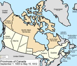
The Patricia Portion is an informal name for the part of the Kenora District lying north of the Albany River, which was transferred from the Northwest Territories to Ontario on May 15, 1912 in the Ontario Boundaries Extension Act, 1912. This area was originally a separate division named Patricia District, but became part of Kenora District in 1937.[8]
With the exception of a few communities along the northernmost ends of Highway 599 and the Highway 105/Highway 125 corridor, the Patricia Portion consists almost entirely of remote First Nations communities which are only accessible by float plane or winter road. Accordingly, the name "Patricia Portion" is still sometimes used to distinguish the area from the more populated southern portion of the district.
See also
References
- 1 2 3 "Kenora District census profile". 2011 Census of Population. Statistics Canada. Retrieved 2012-03-20.
- ↑ Compilation of Northwestern Ontario's 2006 census data
- ↑ Patricia Act Retrieved on March 26, 2016
- ↑ Caldera Volcanoes Retrieved on July 20, 2007
- ↑ "2006 Community Profiles". Canada 2006 Census. Statistics Canada. March 30, 2011. Retrieved 2012-03-20.
- 1 2 "2001 Community Profiles". Canada 2001 Census. Statistics Canada. February 17, 2012. Retrieved 2012-03-20.
- ↑ Barnes, Michael (1995). Gold in Ontario. Erin: The Boston Mills Press. pp. 23–26. ISBN 155046146X.
- ↑ Patricia Act Retrieved on March 26, 2016
| Wikimedia Commons has media related to Kenora District, Ontario. |
 |
Division 23 |
Hudson Bay | | |
| Division 22 Division 19 Division 1 |
|
James Bay | ||
| ||||
| | ||||
| Rainy River, Thunder Bay, Cochrane Districts |
| Regions | |
|---|---|
| Counties | |
| Districts | |
| Regional municipalities | |
| Single-tier municipalities | |
| Separated municipalities | |
| |