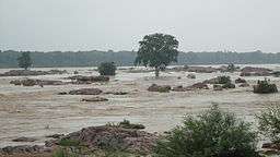
Ken River
| Ken River | |
| River | |
 Ken river | |
| Country | India |
|---|---|
| States | Madhya Pradesh, Uttar Pradesh |
| Region | Bundelkhand |
| Landmark | Raneh Falls |
| Source | Ahirgawan |
| - location | Kaimur Range, Jabalpur district, Madhya Pradesh |
| - elevation | 550 m (1,804 ft) |
| Mouth | Yamuna River |
| - location | Chilla, Fatehpur district, Uttar Pradesh |
| - coordinates | 25°46′N 80°31′E / 25.767°N 80.517°ECoordinates: 25°46′N 80°31′E / 25.767°N 80.517°E |
| Length | 427 km (265 mi) |
| Discharge | |
| - average | 310 m3/s (10,948 cu ft/s) [1] |
The Ken River is one of the major rivers of the Bundelkhand region of central India, and flows through two states, Madhya Pradesh and Uttar Pradesh. It is a tributary of the Yamuna,
Course
The Ken River originates near village Ahirgawan on the north-west slopes of Barner Range in Jabalpur district[2] and travels a distance of 427 km, before merging with the Yamuna at Chilla village,district Banda in Uttar Pradesh at 25°46′N 80°31′E / 25.767°N 80.517°E
Ken has an overall drainage basin of 28,058 km2, out of which 12,620 km2 belong to Sonar River its largest tributary, whose entire basin lies in Madhya Pradesh; and along its 427 kilometres (265 mi) course it receives water from its own tributaries such as Bawas, Dewar, Kaith and Baink on the left bank, and Kopra and Bearma of the right. Out of its total length of 427 kilometres (265 mi) it flows for 292 kilometres (181 mi) in Madhya Pradesh, 84 kilometres (52 mi) in Uttar Pradesh, and 51 kilometres (32 mi) forms the boundary between the two states.[3][4]
Crossing the Bijawar-Panna hills, the Ken River cuts a 60 km long, and 150–180 m deep gorge. Several streams join the Ken in this gorge making waterfalls. The Ken valley separates the Rewa Plateau from the Satna Plateau.[5]

Tourist attraction
The Raneh Falls on the Ken river and Ken Ghariyal Sanctuary are tourist attractions. The rocks formed here present a spectacular view of different hues made of Granite, Dolomite and Quartz. Gangau Dam has been constructed at the confluence of the Ken and Simri rivers.[6] The Ken River passes through Panna National Park.[7]
The banks of the Ken River have quite a few castles which were used by the Rajputs of this region to fight against the Mughals. Nowadays some of these castles are occupied by dacoits and are a cause for worry for the local police. These castles are in such a state of ruin that the walls are difficult to see from below the hill they are built on and ruins of only key buildings still exist. Some of these castles make for a good trek.
It is famous for its rare Sajhar or Dendritic Agate stone. Banda city is located on banks of river Ken.
References
- ↑ "Hydrology" (PDF). nwda.gov.in. National Water Development Authority. Retrieved 22 April 2014.
- ↑ "Chapter 2 – Physical Features" (PDF). Archived from the original (PDF) on November 7, 2007. Retrieved 2010-07-15.
- ↑ Jain, Sharad K.; Pushpendra K. Agarwal; Vijay P. Singh (2007). Hydrology and water resources of India- Volume 57 of Water science and technology library - Tributaries of Yamuna river. Springer. p. 354. ISBN 1-4020-5179-4.
- ↑ "A Watershed" (PDF). Envis Madhya Pradesh. Retrieved 2010-07-15.
- ↑ Sharma, Shri Kamal. Spatial framework and economic development. p. 22. Google books. Retrieved 2010-07-11.
- ↑ "Khajuraho Attractions". Sulekha. Retrieved 2010-07-15.
- ↑ "Ken River Lodge". Nature Safari India. Retrieved 2010-07-15.