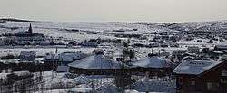
Kautokeino
| Kautokeino kommune Guovdageainnu suohkan | |||
|---|---|---|---|
| Municipality | |||
 | |||
| |||
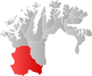 Kautokeino within Finnmark | |||
| Coordinates: 69°0′42″N 23°2′36″E / 69.01167°N 23.04333°ECoordinates: 69°0′42″N 23°2′36″E / 69.01167°N 23.04333°E | |||
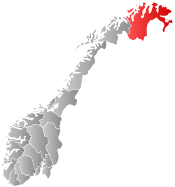
| Country | Norway | ||
| County | Finnmark | ||
| Administrative centre | Kautokeino | ||
| Government | |||
| • Mayor (2015) | Johan Vasara (SáB) | ||
| Area | |||
| • Total | 9,707.35 km2 (3,748.03 sq mi) | ||
| • Land | 8,970.28 km2 (3,463.44 sq mi) | ||
| • Water | 737.07 km2 (284.58 sq mi) | ||
| Area rank | 1 in Norway | ||
| Population (2014) | |||
| • Total |
2,931 ( | ||
| • Rank | 274 in Norway | ||
| • Density | 0.30/km2 (0.8/sq mi) | ||
| • Change (10 years) | -2.4 % | ||
| Time zone | CET (UTC+1) | ||
| • Summer (DST) | CEST (UTC+2) | ||
| ISO 3166 code | NO-2011 | ||
| Official language form | Bokmål and Sami | ||
| Website |
www | ||
|
| |||
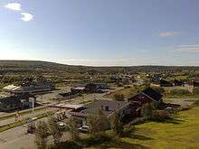
![]() Kautokeino (Norwegian) or Guovdageaidnu (Northern Sami) (also: Finnish: Koutokeino and Kven: Koutokeino) is a municipality in Finnmark county, Norway. The administrative centre of the municipality is the village of Guovdageaidnu/Kautokeino. Other villages include Láhpoluoppal and Máze.
Kautokeino (Norwegian) or Guovdageaidnu (Northern Sami) (also: Finnish: Koutokeino and Kven: Koutokeino) is a municipality in Finnmark county, Norway. The administrative centre of the municipality is the village of Guovdageaidnu/Kautokeino. Other villages include Láhpoluoppal and Máze.
Guovdageaidnu-Kautokeino is one of two cultural centers of Northern Sápmi today (other being Kárášjohka-Karasjok). The most significant industries are reindeer herding, theatre/movie industry, and the public education system.
General information
The municipality of Kautokeino was established in 1851 when the southern part of the old Kistrand municipality was separated to form this new municipality. Initially, there were 869 residents in the new municipality.[1]
Name
The first element in Guovdageaidnu is guovda which means "middle" or "half" and the last element is geaidnu which means "road". Combined it means "half way", since the location is half way between two traditional migrating points. It is also the geographic centre of Northern Sápmi. Kautokeino is a Finnicized form of the Sámi name Guovdageaidnu, and it is also used by Norwegians.
The name of the municipality was KautoKeino until 1987 when it was changed to Guovdageaidnu-Kautokeino.[2] It was the first municipality in Norway to get a Sami name. In 2005, the name was again changed, such that the either Guovdageaidnu or Kautokeino can be used.[3]
Coat of arms
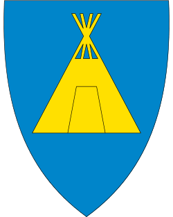
The Coat of arms of Kautokeino were granted on 4 September 1987. The arms show a gold-colored lavvu on a blue background. The lavvo is still in use by reindeer herders who follow their herds around according to season and availability of food for the animals, and so it was chosen as the symbol for the municipality.[4]
History
In 1845 measurements were made for Struve Geodetic Arc at mountain tops Lodiken (Luvdiidcohkka) and Bealjasvarri.[5]
In 1852, Kautokeino was the site of a Sami uprising against representatives of the Norwegian authorities. This was one of the few violent reactions by the Sami against the exploitation policies of the Norwegian government and was the only known confrontation between Samis and Norwegians with loss of human lives.
Churches
The Church of Norway has one parish (sokn) within the municipality of Kautokeino. It is part of the Indre Finnmark deanery in the Diocese of Nord-Hålogaland.
| Parish (sokn) | Church name | Location | Year built |
|---|---|---|---|
| Kautokeino | Kautokeino Church | Kautokeino | 1958 |
| Láhpoluoppal Chapel | Láhpoluoppal | 1967 | |
| Masi Church | Masi | 1965 |
Government
All municipalities in Norway, including Kautokeino, are responsible for primary education (through 10th grade), outpatient health services, senior citizen services, unemployment and other social services, zoning, economic development, and municipal roads. The municipality is governed by a municipal council of elected representatives, which in turn elect a mayor.
Municipal council
The municipal council (Kommunestyre) of Kautokeino is made up of 19 representatives that are elected to every four years. Currently, the party breakdown is as follows:[6]
| Party Name | Name in Norwegian | Number of representatives | |
|---|---|---|---|
| Labour Party | Arbeiderpartiet | 5 | |
| Conservative Party | Høyre | 1 | |
| Liberal Party | Venstre | 2 | |
| Local Lists | Lokale lister | 11 | |
| Total number of members: | 19 | ||
Geography
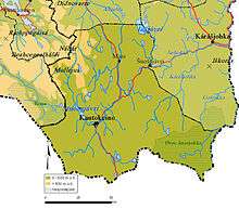
Guovdageaidnu/Kautokeino is the southernmost municipality of Finnmark county and it shares a border with several municipalities: Alta Municipality to the north, Kárášjohka - Karasjok to the east, Nordreisa and Kvænangen (in Troms county) to the west, and Enontekiö (Finland) to the south.
At 9,707 square kilometres (3,748 sq mi), it is the largest municipality in Norway. A total of approximately 10,000 lakes cover 737 square kilometres (285 sq mi). A significant part of the Finnmarksvidda plateau is located inside Kautokeino municipality. Øvre Anárjohka National Park is partially located in the municipality. The rivers Anarjohka and Karasjohka have their headwaters inside the park.
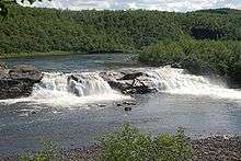
The Guovdageaidnu-Kautokeino River runs from a lake at the Finnish border, north through the villages of Guovdageaidnu (Kautokeino) and Máze before it leaves into Alta municipality and changes name to Altaelva. The river is collectively known as the Kautokeino/Alta-vassdraget and was the site of a major political controversy in the late 1970s and early 1980s. The lake Šuoikkatjávri is located on the border of the municipality with Kvænangen. Other lakes in the municipality include Bajášjávri, Bajit Spielgajávri, Biggejávri, Čárajávri, Dátkojávri, Gahččanjávri, Gavdnjajávri, Geađgejávri, Geašjávri, Guolehis Suolojávri, Heammojávri, Iešjávri, Láhpojávri, Latnetjávri, Nuorbejávri, Rágesjávri, Sálganjávri, Soagŋojávri, Stuora Galbajávri, Stuorajávri, Šuoikkatjávri, Suolojávri, Virdnejávri, and Vuolit Spielgajávri.
Climate
Guovdageaidnu-Kautokeino is located in the Arctic highlands of Northern Norway. During five weeks of summer, the sun doesn't set, and during six weeks of winter, the sun doesn't rise.
Average precipitation is 360 millimetres (14.2 in) per year, which is one of the lowest average amounts of precipitation in the country. It is also claimed that this is comparable to parts of the Sahara desert, with the major difference being that with the lower temperatures and greater vegetation, Kautokeino doesn't dry up as fast.
During summer, daytime temperatures typically range between 10 °C (50 °F) and 25 °C (77 °F). While this is nice for humans, the temperature, combined with 10,000 lakes, makes it a haven for mosquitos. Consequently, both humans and reindeer tend to flee to the coast for the summer. Sihcjavri in Guovdageaidnu-Kautokeino municipality has recorded the warmest temperature ever in Northern Norway: 34.3 °C (93.7 °F) on 23 June 1920.
While winter usually lasts from mid-October until mid-May, the hard winter is only for December–February. During hard winter, temperatures can drop as far as −45 °C (−49 °F) and beyond. The yearly average temperature over the last 30 years is −2.7 °C (27.1 °F).
The dry climate, however, makes the cold temperatures more bearable; −12 °C (10 °F) in Guovdageaidnu-Kautokeino feels the same way as 0 °C (32 °F) feels on the coast. The dryness combined with cold also makes Guovdageaidnu-Kautokeino a prime spot to watch the Aurora Borealis.
| Climate data for Kautokeino | |||||||||||||
|---|---|---|---|---|---|---|---|---|---|---|---|---|---|
| Month | Jan | Feb | Mar | Apr | May | Jun | Jul | Aug | Sep | Oct | Nov | Dec | Year |
| Average high °C (°F) | −11.1 (12) |
−10.4 (13.3) |
−6.4 (20.5) |
−0.7 (30.7) |
5.8 (42.4) |
13.8 (56.8) |
16.5 (61.7) |
13.9 (57) |
8.0 (46.4) |
0.5 (32.9) |
−5.7 (21.7) |
−9.3 (15.3) |
1.2 (34.2) |
| Daily mean °C (°F) | −16.0 (3.2) |
−14.8 (5.4) |
−10.9 (12.4) |
−4.3 (24.3) |
2.8 (37) |
9.8 (49.6) |
12.4 (54.3) |
10.3 (50.5) |
4.9 (40.8) |
−2.0 (28.4) |
−9.3 (15.3) |
−14.3 (6.3) |
−2.6 (27.3) |
| Average low °C (°F) | −21.6 (−6.9) |
−20.4 (−4.7) |
−16.6 (2.1) |
−10.5 (13.1) |
−2.3 (27.9) |
4.3 (39.7) |
7.1 (44.8) |
5.3 (41.5) |
0.8 (33.4) |
−5.9 (21.4) |
−14.1 (6.6) |
−19.7 (−3.5) |
−7.8 (18) |
| Average precipitation mm (inches) | 19 (0.75) |
15 (0.59) |
13 (0.51) |
17 (0.67) |
24 (0.94) |
46 (1.81) |
63 (2.48) |
62 (2.44) |
45 (1.77) |
31 (1.22) |
23 (0.91) |
18 (0.71) |
376 (14.8) |
| Average precipitation days (≥ 1 mm) | 5.6 | 4.0 | 4.7 | 4.8 | 5.1 | 7.9 | 10.5 | 10.8 | 9.1 | 8.4 | 6.8 | 5.7 | 83.4 |
| Source: Norwegian Meteorological Institute[7] | |||||||||||||
Birdlife
Lying south in the county, and bordering with Finland, Guovdageaidnu/Kautokeino has a very interesting birdlife. There are virtually thousands of lakes in the municipality, and these combined with the Altaelva waterway system provide habitats for a whole host of wetland species. whooper swan can sometimes be found while spotted redshank are not uncommon.
Transportation
The nearest airports are Alta Airport, about 140 kilometres (87 mi) from Kautokeino, and Enontekiö Airport, about 90 kilometres (56 mi) from Kautokeino. The small Kautokeino Airport is located in the village, but it has no commercial services. Norwegian National Road 93 runs through Kautokeino, part of the shortest and fastest route between western Finnmark and southern Scandinavia.
Population
In the village of Guovdageaidnu/Kautokeino, about 1,300 of the 3,000 people in the municipality reside. The village of Máze has about 400 people, while the remaining people in the municipality live in 14 smaller villages scattered around the area. The population has been declining about 3% over the last 10 years.
Guovdageaidnu/Kautokeino has different demographics than Finnmark county and Norway as a whole: more than 50% of the population is younger than 30 years. Also, the number of people older than 66 years is half of the national average. The gender ratio amounts to 86 women for every 100 men.[8] For the last couple of years, Kautokeino has been plagued by high rates of unemployment, peaking at 10% in 2006/2007.[9]
Villages
In addition to the administrative centre of Guovdageaidnu (Kautokeino), the municipality has 15 smaller villages:
- Máze (Masi) is the largest of the villages. Máze is located in a river valley. There is a school and Masi Church located in Máze. The current church has 150 seats and was built of wood in 1965. The first chapel was built in the 17th century. The second by Thomas von Westen in 1721. This church was burnt during World War II in 1944. The village was the site of a major political controversy in the late 1970s and early 80s, when it was proposed to flood village to build a large hydroelectric dam.
- Láhpoluoppal is a village located northeast of Guovdageaidnu at the southern end of the Láhppojávri lake. The village has a school, Láhpoluoppal Chapel, and mountain hut (Norwegian: fjellstue). The chapel has 70 seats and was built in 1967.
- Šihččajávri is located southeast of Guovdageaidnu (Kautokeino) village. The Norwegian Meteorological Institute has a weather observation station in the village, and often the place has the lowest temperature in Norway.
- Ávži is a village 10 kilometres (6 mi) east of Guovdageaidnu. During the Sami revolt in Guovdageaidnu, the group of Samis that captured the rebellions was organized here.
- Siebe is a village south of Guovdageaidnu.
- Mieron is a village north of Guovdageaidnu. Many of the Samis who traveled to Canada to teach the Inuit about reindeer herding were from Mieron.
- Stornes is a village north of Guovdageaidnu. Close to Stornes is a slate field with distinct green quartzite marketed as Naranas.
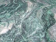 Naranas quartzite.
 - Šuoššjávri is a village northeast of Guovdageaidnu near the border with Karasjok with a chapel and a mountain hut. The chapel was built in 1968 and has 75 seats.
- Čunovuohppi is a small village with few houses and is 11 kilometres (7 mi) west of Guovdageaidnu. The village has a mountain hut (called Madame Bongos fjellstue).
- Suolovuopmi is north of Guovdageaidnu near the border with Alta. It is the location of a mountain hut, and is used for metrological observations.
- Gálaniitu is southwest of Guovdageaidnu and has a mountain hut.
- Áidejávri is south of Guovdageaidnu close to the Finnish border.
- Ákšomuotki (Økseidet) is south of Guovdageaidnu.
- Soahtefielbma is about 10 kilometres (6 mi) west of Guovdageaidnu.
Institutions and media
Several Sámi institutions are located in Guovdageaidnu/Kautokeino, including:
- Beaivváš Sámi Theatre. The National Sámi Theatre. As a national stage company, they play a major role in making Sámi history and culture visible.
- Sámi Joatkkaskuvla ja Boazodoalloskuvla is the Sámi High School and Reindeer Herding School. The high school has emphasis on Sámi, rather than Norwegian culture. Most teachers speak Sámi as their mother tongue allowing for classes to be taught in Sámi. In addition to ordinary courses, students can also study duodji (traditional Sámi crafts) and reindeer herding. In fact, it is the only high school in the world that features a reindeer herding class.
- Sámi allaskuvla - the Sámi University College. The College has national responsibility for Sámi higher education, including teacher-, and journalist-training. The college attempts to develop the syllabuses on the basis of Sámi needs, and attempts to develop Sámi as an academic language.
- Nordic Sámi Institute. The Nordic Sámi Institute is a Sámi research institution. Research topics include the Sámi language, culture, reindeer husbandry and legal research. The institute published the DIEĐUT magazine.
- Sámi giellaossodat; The department of language at the Norwegian Sami Parliament. This department is the administration for the Sámi language board, it allocates the extra funding given to the municipalities that have Sámi as an official language (like Guovdageaidnu-Kautokeino), and it administrates various projects related to Sámi languages.
- The department of education of the Norwegian Sami Parliament.
The Sámi are also internationally active with regards to indigenous people issues and reindeer husbandry. Therefore, the following institutions are also located in Guovdageaidnu/Kautokeino:
- Resource Centre for the Rights of Indigenous Peoples. The center attempts to collect, organize, and disseminate the knowledge and understanding of indigenous peoples’ and Sami peoples’ rights.
- International Centre For Reindeer Husbandry.
Guovdageaidnu/ Kautokeino is home to the following Sami media companies:
- Áššu a Sami language newspaper.
- DAT Sami publishing house and record company.
Cultural events
Guovdageaidnu-Kautokeino is perhaps the cultural center of Northern Sámi today, and hosts several of the most well known Sami cultural events. The biggest event is the Sámi Easter Festival. Easter has traditionally been the time when the Sámis gather to celebrate weddings and confirmations. Today, also the Sami culture is celebrated with many yoik concerts, Sami theater shows, reindeer races, snowmobile races, ice fishing competitions, parties, and the Sámi Melody Grand Prix; a Sámi version of the Eurovision Song Contest where in addition to the best song, the best yoik is also selected. In addition, the Sami Film Festival is usually held during the Easter, which is notable for having an outdoor cinema made of snow.[10]
In June, the annual Guovdageaidnu-Kautokeino Walk/Bicycle Ride, has Sámis return to Guovdageaidnu-Kautokeino, just to walk a few kilometers, or ride a bicycle for twice the distance.
In August, there is the White Fish festival, as well as the Autumn Festival. The latter is a weekend-long party full of concerts, but also includes snowmobile skipping races on the (unfrozen) river. If the riders go too slow or make too sharp a turn, the snowmobile sinks.
Notable residents
- Ingor Ánte Áilo Gaup (Iŋgor Ántte Áilu Gaup) - Musician and actor
- Ingor Ante Ante Mihkkal Gaup - Joiker
- Nils Gaup - director who earned an Academy Award Nomination for his movie "Pathfinder"
- Annbjørg Hætta - Vocalist - Joik/Pop
- Håvard Klemetsen - a Nordic combined skier with a gold and bronze team medals at the FIS Nordic World Ski Championships.
- Roger Ludvigsen - Sami guitarist, percussionist and composer
- Ole Henrik Magga - the first president of the Sami Parliament of Norway and currently the president of the UN permanent forum for indigenous people.
- Niko Valkeapää - Musician, winner of the Norwegian Spelemannsprisen in 2004. (Originally from Finland, but he lives in Kautokeino)
References
- ↑ Jukvam, Dag (1999). "Historisk oversikt over endringer i kommune- og fylkesinndelingen" (PDF) (in Norwegian). Statistisk sentralbyrå.
- ↑ "Ot.prp. nr. 111 (2001-2002)" (in Norwegian). Regjeringen.no.
- ↑ "Endring av skrivemåten for tospråklige kommuner. Endring av skrivemåten for tospråklige kommunenavn, Guovdageaidnu-Kautokeino" (in Norwegian).
- ↑ "Kommunevåpen". Flags of the World. 28 June 2002. Retrieved 28 September 2008. External link in
|publisher=(help) - ↑ Kuriosetet ved HiST
- ↑ "Table: 04813: Members of the local councils, by party/electoral list at the Municipal Council election (M)" (in Norwegian). Statistics Norway. 2015.
- ↑ "eKlima Web Portal". Norwegian Meteorological Institute.
- ↑ "Kautokeino kommune" (in Norwegian).
- ↑ "Finnmarkstatistikken: Yrkesdeltaking 2006" (in Norwegian).
- ↑ Bevanger, Lars (2004-06-04). "Drive-in cinema is Norway's coolest". BBC News.
External links
| Wikimedia Commons has media related to Kautokeino. |
- Kautokeino Municipality Official Website (Norwegian)
- Destinasjon Kautokeino Tourist office (Norwegian)
- Kautokeino.Com is the major online "meeting point" (Norwegian)
- Sámi Joatkkaskuvla ja Boazodoalloskuvla (Norwegian)
- Sámi University College
- Beaivvas Sámi Teahter
- kautokeino.net News and information about events in Kautokeino (Norwegian)