Katuwana fort
| Katuwana Fort | |
|---|---|
| Part of Hambantota District | |
| Katuwana, Sri Lanka | |
 Katuwana Fort | |
| Coordinates | 6°16′3″N 80°41′42″E / 6.26750°N 80.69500°E |
| Type | Defence fort |
| Height | 5 m (16 ft) |
| Site information | |
| Open to the public | yes |
| Condition | good |
| Site history | |
| Built | 1646 |
| Built by | Dutch |
Katuwana Fort (Sinhalese: කටුවන බලකොටුව) (also known as Fort Catuna or Fort Catoene), is an inland fort constructed by the Dutch in 1646.[1][2]

The Dutch generally built forts along the coastal areas to protect strategic harbours and anchorages from other colonial forces, such as the Portuguese. They did however construct some forts inland, primarily to defend the coastal lowland areas from attacks by the Kingdom of Kandy. Katuwana fort was built approximately 40 km (25 mi) from Matara, in the Kandyan foothills at the northern limits of the Dutch East India Company's territory.[3]
The fort was located on the slope of a hill, with 5 m (16 ft) high ramparts, a single gateway and a 4 m (13 ft) walkway on top. It was diagonal in shape, with two bastions, which each accommodated six cannon,[3] as a result it was often described as a redoubt rather than a fort.
In 1761 during the 'Matara Rebellion' the fort was captured by Kirti Sri Rajasinha's Kandyan forces and partly destroyed.[3] Following the anexure of the Kandy Kingdom by the British in 1815 the fort lost its strategic value and was abandoned.
References
- ↑ "Katuwana". VOC Sri Lanka. Retrieved 18 November 2014.
- ↑ Fernando, Kishanie S. (9 June 2013). "Colonial Forts – relics of old time warfare". Ceylon Today. Retrieved 18 November 2014.
- 1 2 3 Kulatunge, Manuri (19 May 2013). "Forgotten Fort of Katuwana". The Nation. Retrieved 18 November 2014.
Further reading
- Nelson, William A.; de Silva, Rajpal Kumar (1984). The Dutch Forts of Sri Lanka – The Military Monuments of Ceylon. Edinburgh, Scotland: Canongate Books. ISBN 0-86241-062-2.
| Ancient Forts | _fort.jpg) 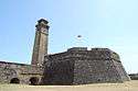 | |
|---|---|---|
| Colonial Forts | ||
Less or no contribution/renovation works of Dutch are marked by † symbol under "Portuguese Forts", and others are considered as Dutch forts too. | ||