Kathmandu District
| Kathmandu काठमाडौं जिल्ला | |
|---|---|
| District | |
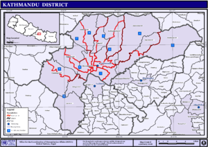
 Location of Kathmandu District in Bagmati Zone | |
| Country | Nepal |
| Region | Central |
| Zone | Bagmati |
| Headquarters | Kathmandu |
| Area | |
| • Total | 395 km2 (153 sq mi) |
| Population (2011) | |
| • Total | 1,744,240 |
| • Density | 4,400/km2 (11,000/sq mi) |
| Time zone | NPT (UTC+5:45) |
| Main language(s) | |
| Website | Official website |
Kathmandu District (Nepali: काठमाडौं जिल्ला![]() Listen ; Nepal Bhasa: येँ जिल्ला) is a district located in Kathmandu Valley, Province No. 3 of Nepal, a landlocked country in South Asia. It is one of the 75 districts of Nepal, covers an area of 395 km2 (153 sq mi), and is the most densely populated district of Nepal with 1,081,845 inhabitants in 2001 and 1,744,240 in 2011.[1] The district's headquarters is Kathmandu Metropolitan City, also the capital of Nepal.
Listen ; Nepal Bhasa: येँ जिल्ला) is a district located in Kathmandu Valley, Province No. 3 of Nepal, a landlocked country in South Asia. It is one of the 75 districts of Nepal, covers an area of 395 km2 (153 sq mi), and is the most densely populated district of Nepal with 1,081,845 inhabitants in 2001 and 1,744,240 in 2011.[1] The district's headquarters is Kathmandu Metropolitan City, also the capital of Nepal.
Geography
Kathmandu district is one of the three districts located in Kathmandu Valley, which itself is located in the hills of Bagmati Zone, Central Development Region, Nepal. The district is located from 27°27′E to 27°49′E longitude and 85°10′N to 85°32′N latitude.[2]
The district is surrounded by:
- East: Bhaktapur District and Kavrepalanchok District
- West: Dhading District and Nuwakot District
- North: Nuwakot District and Sindhupalchok District
- South: Lalitpur District and Makwanpur District
The altitude of the district ranges from 1,262 m (4,140 ft) to 2,732 m (8,963 ft) above sea level.[2]
Geography and Climate
| Climate Zone[3] | Elevation Range | % of Area |
|---|---|---|
| Subtropical | 1,000 to 2,000 meters 3,300 to 6,600 ft. |
88.2% |
| Temperate | 2,000 to 3,000 meters 6,400 to 9,800 ft. |
11.8% |
In the urban center, the temperature fluctuates between 32 °C in summer (June–July) to -2 °C in winter (December–January).[2] The annual rainfall of the district is 176.4 ml.[2]
Culture
Kathmandu district is a part of Kathmandu valley, which is a melting pot of various cultural groups, ethnicities, races, languages and religions. This vibrant culture is illustrated in the culture of the natives of the district, known as Newars, who are a multiethnic, multiracial, multireligious people bound by a Sanskritized Sino-Tibetan language of Kirat origins known as Nepal Bhasa. All the ancient settlements of the district have specific street festivals (jatras) arranged according to specific dates of the Nepal Sambat calendar. The main festivals celebrated are:
- Yanya Punhi – literally meaning Kathmandu's full moon, a week-long festival during the Yenla (the month of Kathmandu) of Nepal Sambat, a festival started by Gunakamadev, the founder of Kathmandu city to commemorate the establishment of city
- Gunla – a month in which musical bands and ordinary people make pilgrimage to Swayambhunath temple
- Mohani or Dashain – the main festival of Nepal, celebrated by visiting the various Shaktipeeths around the city
- Shivaratri – a very special festival in which people make small fire all around the city and take different types of toxic in order to show love to Lord Shiva
- Buddha Jayanti
- Sa Paru – a comic festival to commemorate dead relatives, celebrated during the full moon of Goon la
- Chatha – the birthday of Lord Ganesha of Hindu pantheon
- Holi
- Pahan Chare – a festival of Animist origin celebrated by procession of matriarchs of Kathmandu
- Shree Panchami – in the past children used to formally start education on this day. Presently, deities of wisdom, Saraswati and Manjushree (the mythological founder of the valley) are worshipped on this day
- Swanti or Tihar – a five-day festival, the third day of which is called Laxmi Puja, when the families do their annual financial calculation and the next day marks the New Year according to Nepalese calendar, Nepal Sambat.
Along with these festivals, with the influx of population from other parts of Nepal, India, Tibet and South Asia, other festivals such as Teej, Chhath, Sakela, Lhosar, Janai Purnima, Deuda etc. are also celebrated.
Economy
Most of the offices and industry of Nepal are in Kathmandu. The major economic hubs are New Road, Durbar Marg, Putalisadak, Asan. The district exports handicrafts, artworks, garments, pashmina, paper etc. Tourism is one of the main industries of the district. Hindu and Buddhist pilgrims from all over the world visit various religious places located in the district such as Pashupatinath, Swayambhunath, Boudhanath, Buddhanilkantha etc. Freak Street and Thamel are noted tourist destinations for Western tourists.
Education
Kathmandu district is the pioneer district in education in many aspects in Nepal. Durbar High School (the first school of Nepal), Trichandra College (the first college of Nepal), Padma Kanya College (the first women's college) are all located in Kathmandu city. Tribhuwan University, the first university of Nepal, is located in Kirtipur municipality of Kathmandu district. Besides these, thousands of educational institutions are located in the district which cater students from Nepal, India, Bangladesh etc.
Administration
The district consists of 11 Municipalities.[4] These are as follows:
- Budanilkantha
- Chandragiri
- Dakshinkali
- Gokarneshwar
- Kageshwari Manohara
- Kathmandu
- Kirtipur
- Nagarjun
- Shankharapur
- Tarakeshwar
- Tokha
Demographics
The total population of the district is 1,744,240 out of which 913,001 are male and 831,239 female in 436,355 households. Average family size was 4.6 in 2001 and 4.0 in 2011 [5]
Hospitals
- Bir Hospital
- Teaching Hospital
- Chhetrapati free Hospital(Chhetrapati Nishulka Chikitsalaya)
- Babukaji Memorial Hospital
- Gangalal Hridaya Kendra
- Manmohan Memorial Hospital
- tilganga eye hospital
See also
References
- ↑ "National Population and Housing Census 2011 – General and Social Characteristics Table" (PDF). Government of Nepal Central Bureau of Statistics. February 2014. pp. 9(1),10(2). Retrieved 15 August 2014.
- 1 2 3 4 "Brief Introduction" (in Nepali). DDC Kathmandu. Retrieved 15 August 2014.
- ↑ The Map of Potential Vegetation of Nepal - a forestry/agroecological/biodiversity classification system (PDF), Forest & Landscape Development and Environment Series 2-2005 and CFC-TIS Document Series No.110., 2005, ISBN 87-7903-210-9, retrieved Nov 22, 2013
- ↑ "New Municipality". LGCDP.
- ↑ DDC Kathmandu statistical report
External links
- "Districts of Nepal". Statoids.
- DDC Kathmandu
- UN map of VDC boundaries, water features and roads in Kathmandu
- Rainfall in Kathmandu
Coordinates: 27°42′N 85°18′E / 27.7°N 85.3°E
| Wikimedia Commons has media related to Kathmandu District. |