Kasigluk Airport
| Kasigluk Airport | |||||||||||
|---|---|---|---|---|---|---|---|---|---|---|---|
|
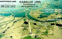
Aerial photo showing runway prior to expansion | |||||||||||
| IATA: KUK – ICAO: PFKA – FAA LID: Z09 | |||||||||||
| Summary | |||||||||||
| Airport type | Public | ||||||||||
| Owner | State of Alaska DOT&PF - Central Region | ||||||||||
| Serves | Kasigluk, Alaska | ||||||||||
| Elevation AMSL | 40 ft / 12 m | ||||||||||
| Coordinates | 60°52′24″N 162°31′28″W / 60.87333°N 162.52444°W | ||||||||||
| Runways | |||||||||||
| |||||||||||
| Statistics | |||||||||||
| |||||||||||
Kasigluk Airport (IATA: KUK[3], ICAO: PFKA[4], FAA LID: Z09) is a state-owned public-use airport located two nautical miles (4 km) south of the central business district of Kasigluk, in the Bethel Census Area of the U.S. state of Alaska.[1]
As per Federal Aviation Administration records, this airport had 4,001 passenger boardings (enplanements) in calendar year 2007, a decrease of 5% from the 4,218 enplanements in 2006.[2]
Facilities
Kasigluk Airport has one runway designated 17/35 with a gravel surface measuring 3,000 by 60 feet (914 x 18 m).[1] The runway was previously 1,950 by 50 feet.[5]
Airlines and non-stop destinations
| Airlines | Destinations |
|---|---|
| Flight Alaska | Bethel |
| Ravn Alaska | Nunapitchuk[6] |
Top Destinations
| Rank | City | Passengers | Carriers |
|---|---|---|---|
| 1 | |
3,000 | Grant, Hageland |
References
- 1 2 3 FAA Airport Master Record for Z09 (Form 5010 PDF), effective 2008-07-31.
- 1 2 Preliminary CY 2007 Passenger Boarding and All-Cargo Data. Federal Aviation Administration. 2008-07-17.
- ↑ KUK: Kasigluk Airport, Alaska. Great Circle Mapper. Retrieved 2008-09-21.
- ↑ PFKA: Kasigluk Airport, Alaska. AirNav.com. Retrieved 2008-09-21.
- ↑ Aerial photo showing runway prior to expansion. Federal Aviation Administration. June 1998.
- ↑ Scheduled Flights (PDF). Hageland Aviation Services. Retrieved 2007-08-31.
- ↑ http://www.transtats.bts.gov/airports.asp?pn=1&Airport=KUK&Airport_Name=Kasigluk,%20AK:%20Kasigluk%20Airport&carrier=FACTS
External links
- FAA Alaska airport diagram (GIF)
- Resources for this airport:
- FAA airport information for Z09
- AirNav airport information for Z09
- ASN accident history for KUK
- FlightAware airport information and live flight tracker
- SkyVector aeronautical chart for Z09
This article is issued from Wikipedia - version of the 8/25/2014. The text is available under the Creative Commons Attribution/Share Alike but additional terms may apply for the media files.