Karunagappalli
| Karunagappally കരുനാഗപ്പള്ളി Karunagappally | |
|---|---|
| Municipal Town | |
|
Karunagappally Town Ariel View | |
 Karunagappally  Karunagappally Location in Kerala, India | |
| Coordinates: 9°3′16″N 76°32′7″E / 9.05444°N 76.53528°ECoordinates: 9°3′16″N 76°32′7″E / 9.05444°N 76.53528°E | |
| Country |
|
| State | Kerala |
| District | Kollam |
| Government | |
| • Body | Karunagappally Municipality |
| • Chairperson | M Sobhana |
| • Vice Chairman | Sakeena Salam |
| Area | |
| • Total | 66.34 km2 (25.61 sq mi) |
| Elevation | 14 m (46 ft) |
| Population (2011) | |
| • Total | 25,336[1] |
| • Density | 856/km2 (2,220/sq mi) |
| Languages | |
| • Official | Malayalam, English |
| Time zone | IST (UTC+5:30) |
| PIN | 690518 |
| Telephone code | +91 (0)4762 |
| ISO 3166 code | IN-KL |
| Vehicle registration | KL-23 |
| Nearest city | Kollam (27 km) |
| Sex ratio | 999 ♂/♀ |
| Literacy | 94.26% |
| Civic agency | Karunagappally Municipality |
| Climate | Am/Aw (Köppen) |
| Avg. annual temperature | 27.2 °C (81.0 °F) |
| Avg. summer temperature | 35 °C (95 °F) |
| Avg. winter temperature | 24.4 °C (75.9 °F) |
.jpg)
Karunagappalli, also written as Karunagappally (Malayalam: കരുനാഗപ്പള്ളി), is a municipality in Kollam district of Kerala, India. Karunagappalli is situated 27 km north of Kollam and 60 km south of Alappuzha. Karunagappalli taluk consist of Alappad, Ochira, Adinad, Karunagappally, Thazhava, Pavumba, Thodiyoor, Kallalibhagom, Thevalakkara, Chavara, Neendakara, Clappana, Kulasekharapuram, Thekkumbhagam, Ayanivelikulangara, Panmana and Vadakumthala.[2] The Municipality is bound on the north by Kayamkulam, east by Kunnathur taluk, south by Kollam and on the west by the Arabian Sea.It is the major town other than kollam and most developing place in the district
There is one Government Engineering College situates in Karunagappally named: College of Engineering Karunagappally also known as [3] CEK
Tourist attractions
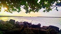
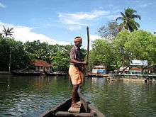
The main tourist attraction is the House boat facility in Alumkadavu which is close (only 3 km) to Karunagappally town.[4] Sree Narayana Trophy boat race, an annual boat race is organised in the Kannety (Pallickal) River, Karunagappally, during the season of Onam Festival. The famous Chinese fishing nets can be found on the banks of the lagoon. The Amritapuri ashram is also situated in vallikavu,which is 8 km from karunagappally. Other tourist attractions are Alumkadavu Backwater, Oachira temple, Pandarathuruth Church, Sheik Masjid Mosque, Padanayarkulangara Mahadeva Temple, Thazhava, Sasthamkotta Lake etc
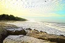
Recently, Azheekal Beach is gaining popularity as a local tourist attraction.
|
Legend
In the name "Karunagappalli", here, "palli" means "mosque" and "karunagam" means black cobra. There once was a famous Islamic spiritual leader, whom the natives called "Karunagappalli Sheikh". Graves of the Sheikh and his 11 companions are found in Karunagapally Sheikh Masjid. It is a beautiful architecture of a muslim mosque. There claims that the name "Karunagappalli" has been named because of the Sheikh (grave in karunagappalli Sheikh Masjid) defeating the cobra where it was situated earlier which made difficulties for the natives. Today, people from all over India belonging to different religions come to the Karunagapalli Sheikh Masjid for prayers and offerings.
Demographics
The 2011 India census puts the population of Karunagappalli Municipality is 25,336.[5] As with the rest of the state the population of the municipality is a heterogeneous mix of Hindu, Muslim and Christian community. The high literacy of Kerala is reflected in Karunagappalli as well with 94.23% of the population classified as literate as against the national average of 74.04%.[6]
Economy
Karungappalli used to be an agrarian economy until the late 19th century with coconut, banana, tapioca and paddy as the main crops grown. With rapid urbanization and the consequent pressure on land the reliance on agriculture has dwindled. Several cottage and small industries have now come up in the area in brick making, engineering and electronics. Proximity to Kollam (27 km) and the excellent road and rail infrastructure have helped in this transition.
The area also receives substantial foreign remittances from the large number of people from here working in the Gulf countries. Fishing forms the major source of livelihood for the coast dwellers.
Environment
Karunagappalli is known for high background radiation from thorium-containing monazite sand. In some coastal panchayats, median outdoor radiation levels are more than 4 mGy/yr and, in certain locations on the coast, it is as high as 70 mGy/yr.[7]
Transport
Both road and rail transport are available. Main road transport is provided by State owned Kerala State Road Transport Corporation (KSRTC) and private transport bus operators. Karunagappally Bus Station is on National Highway 47. Buses available from Karunagappally to Thiruvananthapuram, Alappuzha, Thrissur, Kottayam, Kottarakkara, Kollam, Kodungallur , Guruvayur etc. Local services are also available to various places in the district. The station operates super fast, fast passenger and ordinary buses. KSRTC Bus stand is situated in the heart of the town. Road transport is also supported by private taxis and autorickshaws also called autos.
Karunagappalli railway station, situated in Edakkulangara falls on the Thiruvananthapuram-Ernakulam railway line and only 1.5 km from the KSRTC bus station. Buses and auto rickshaws are available from and to the railway station at all time .Mumbai(Lokamanyathilak)-Thiruvananthapuram-Netravati Express, Kanyakumari-Bangalore Island Express, Sabari Express, Jayanthi-janatha express, Ernad Express, Maveli Express, Vanchinad Express, Parasuram Express, Venad Express, Malabar Express, Amritha Express and Thiruvananthapuram-Guruvayoor Intercity Express, Kollam - Visakhapatnam Express,Trivandrum-Mangalapuram-Trivandrum Express are the main train connections. Station Code: KPY.
Trivandrum International Airport is the nearest airport.
Politics
Karunagapalli assembly constituency is part of Alappuzha Lok Sabha constituency.[8]
Industries
The major employers in the public sector are Indian Rare Earths Limited (IRE) & Kerala Minerals and Metals Limited (KMML) in Shankaramangalam, KERAFED in Puthiyakavu, House Boat Manufacturing in Alumkadavu, the state owned Kerala Feeds Ltd in Kallelibhagom are also major industries.The KMML is the first of its kind.
Cashew nut industry plays a vital role. Western India cashews in Puthiyakavu and Latha cashews in Charamurimuk are the major cashew processing units in town limits. Coconut, Paddy, Tapioca, Banana etc. are the other main agricultural crops. Prominent small scale and cottage industries are based on bricks, well rings making, engineering and electronics items handicrafts etc.
References
- ↑ "Karunagappalli Population - Census 2011". census2011.co.in. Census India. Retrieved 9 January 2016.
- ↑ Taluks & Villages - Kollam District
- ↑ "CEK - College of Engineering Karunagappally". College of Engineering Karunagappally.
- ↑ Karunagappally Tourism at a glance.
- ↑ "Karunagappalli Population - Census 2011". census2011.co.in. Census India. Retrieved 9 January 2016.
- ↑ "Census 2011" (PDF).
- ↑ Nair RR, Rajan B, Akiba S, Jayalekshmi P, Nair MK, Gangadharan P, Koga T, Morishima H, Nakamura S, Sugahara T (January 2009). "Background radiation and cancer incidence in Kerala, India-Karanagappally cohort study.". Health Physics.
- ↑ "Assembly Constituencies - Corresponding Districts and Parliamentary Constituencies" (PDF). Kerala. Election Commission of India. Retrieved 2008-10-20.
External links
| Wikimedia Commons has media related to Karunagappally. |
 |
Alappuzha district | Pathanamthitta district | | |
| Arabian Sea | |
Tirunelveli district, Tamil Nadu | ||
| ||||
| | ||||
| Thiruvananthapuram district |
| |||||||||||||||||||||||||||||||||||||||
| City Corporations |  | ||||||||||||||||||||||
|---|---|---|---|---|---|---|---|---|---|---|---|---|---|---|---|---|---|---|---|---|---|---|---|
| Municipalities | |||||||||||||||||||||||
| Talukas and villages |
| ||||||||||||||||||||||