Karmiel
Karmiel
| |||
|---|---|---|---|
| Hebrew transcription(s) | |||
| • ISO 259 | Karmiˀel | ||
| • Translit. | Karmi'el | ||
| • Also spelled | Carmiel (unofficial) | ||
 | |||
| |||
 Karmiel | |||
| Coordinates: 32°54′49.38″N 35°17′45.92″E / 32.9137167°N 35.2960889°ECoordinates: 32°54′49.38″N 35°17′45.92″E / 32.9137167°N 35.2960889°E | |||
| District | Northern | ||
| Founded | 1964 | ||
| Government | |||
| • Type | City (from 1986) | ||
| • Mayor | Adi Eldar | ||
| Area | |||
| • Total | 19,188 dunams (19.188 km2 or 7.409 sq mi) | ||
| Population (2015)[1] | |||
| • Total | 44,858 | ||
| Name meaning | God's vineyards | ||

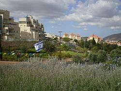
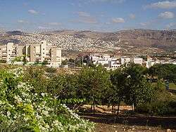
Karmiel (Hebrew: כַּרְמִיאֵל, lit. "God's vineyards") is a city in northern Israel. Established in 1964 as a development town, Karmiel is located in the Beit HaKerem Valley which divides upper and lower Galilee. The city is located south of the Acre-Safed road, 32 kilometres (20 miles) from Safed and 20 km (12 miles) from Ma'alot-Tarshiha and 20 km (12 mi) from Acre. In 2015 Karmiel had a population of 44,858.
History

In 1956, about 1,275 acres (5.16 km2) of land in the Israeli Arab villages of Deir al-Asad, Bi'ina and Nahf were declared "closed areas" by Israeli authorities. This area, near the main road between Acre and Safed, had been an important marble quarrying site. In 1961, the Israeli authorities expropriated the land to build Karmiel. The villagers offered "equally good land" in the area, but when Moshe Sneh (Maki) and Yusef Khamis (Mapam) brought the case to the Knesset on behalf of the villagers, the Knesset established that there was no such land.[2] According to the Haredi newspaper She'arim, about 10 square kilometres (3.9 sq mi) (394 lots) were confiscated by a court order on 4 March 1963, at the request of the Israel Development Authority. However, the land was rocky, uninhabited and unfit for agriculture.[3] In 1964, when local Arabs applied for permission to move into the town, Minister of Housing Yosef Almogi replied that "Karmiel was not built to solve the problems for the people in the surrounding area."[4] In February 1965, 400 protesters marched from Tel Aviv to protest against "discrimination of a group of our citizens". Representatives went to a local police station, informing the police that they were staying in the area without permission. Eventually the perceived leaders were arrested and tried before a military tribunal.[5]
Karmiel was one of the first cities in Israel to be established according to an urban master plan.[6] It was built as part of the Central Galilee Development Project. Work began in 1963, and the official inauguration ceremony took place in October 1964.[7] The first 16 families moved in at that time. A tender for the construction of Karmiel's main roads was issued in 1963, and Mekorot built a water pipe network connecting Karmiel, Rameh, Sha'ab and other nearby villages.[8]
In 1981, Karmiel was awarded the Beautiful Israel prize and the Kaplan Prize for Management and Services. Karmiel achieved city status on November 20, 1986. The first mayor was Baruch Venger, followed by Adi Eldar, who has remained in this position until today. Some 18,000 new immigrants settled in Karmiel between 1990 and 2002.[9]
During the Second Lebanon War in 2006, Hezbollah fired 180 Katyusha rockets into Karmiel and the neighboring villages, leading to casualties and damage to buildings, roads, and cars.[10]
Geography

Karmiel is located on the Acre–Safed road, on the northern edge of the Lower Galilee. It lies in Emek Beit HaKerem and its elevation is 330 m (1,082.68 ft).[11] The Hilazon Stream passes slightly to the south of Karmiel.[11] Its tributaries, the Shezor and Shagor Streams pass through Karmiel on the east and north, respectively.[12] Karmiel sits on the Shagor mountain range, which stretches from Mount Hazon in the east (584 m (1,916.01 ft), next to Maghar) to Mount Gilon in the west (367 m (1,204.07 ft), at Gilon).[13] Western Karmiel was built on the Karmi (362 m) and Makosh (315 m) mountains.[14] Work on a new railway line linking Haifa and Karmiel began in 2011.
Demographics

As of 2007, the city encompasses an area of about 24,000 dunams (24 km²) with a population of about 50,000 residents approximately 40% of whom are immigrants from 75 countries. The city also receives significant internal migration of Haredi families. Since 1990, 16,000 immigrants have arrived in Karmiel, the majority of whom are from the Former Soviet Union. According to the national master plan, by 2020 Karmiel will have a population of approximately 120,000 residents. Since 1980, six new neighborhoods have been developed and populated, and a technical college has been serving the community since 1989. As of 2016, work is underway to create a further neighborhood on Mount Karmi on Karmiel's western fringe.
Local government

Adam Tal was the first official head of the group that founded Karmiel in 1964. Avraham Argov replaced him, and was himself replaced in 1968 by Baruch Venger, who headed the municipality of Karmiel until his death in office on November 22, 1988.[15] His successor was Adi Eldar, who was re-elected several times, most recently in November 2008.[9]
Education
Today there are four high schools, four junior high schools, a vocational training center, nine state-run elementary schools, one state-run religious school (including high school), an independent education elementary school, a school for gifted children and an educational farm, many kindergartens, nursery schools and daycare centers, as well as a network of community youth and sports centers and the international ORT Braude College of Engineering with a student body of 3,500 studying computers, electronics, industrial administration, biotechnology and other subjects. A biotechnology research and development center will also open at the college.[16]
Health care
In 2011, a Terem emergency care clinic was opened in Karmiel. The clinic is under the medical management of Dr. Walid Assadi and is open seven days a week, including Sabbath and holidays.[17]
Culture

The city is known for the Karmiel Dance Festival, a yearly event since 1988. The festival is usually held for 3 days and nights in July, and includes dance performances, workshops, and open dance sessions.[18] The festival began as a celebration of Israeli folk dance, but today it features many different dance forms from all around the globe, and attracts thousands of dancers and hundreds of thousands of spectators from many countries.[19]
"Nitzotz-Machanayim" is a community center which caters to the Russian-speaking population of Karmiel. It is one of a number of similar centers in Israel which operate in the framework of the Machanayim "Communities" project. Rabbi Eli Talberg is the director of Natzotz-Machanyim, which is located on the first floor of "Kikar Ha’Ir" (often called "The Old Mall"). Activities include a Beit-Midrash, conversion classes, Hebrew classes, a youth club, a women’s club, and additional workshops and activities for all ages. The community also organizes regular educational tours throughout Israel and participates in sporting and social events with other branches of the Communities project.[20]
Environmental protection
Karmiel was the first Israeli city to receive ISO 9002 certification for the quality of its services. It is one of the few Israeli cities with ISO 1410 certification for environmental standards. Karmiel has enacted by-laws to protect the environment and prevent pollution, and become a center for clean industries and advanced technology enterprises that abide by these standards.[21]
Parks and gardens
The Holocaust Memorial Park is located at the entrance to the city. The bronze sculptures were made by Jewish sculptor and artist Nicky Imber (1920-1996). The sculptures are separated into three groups: Holocaust, wondering and hope; which represent the story of the Jewish people from the time of the Holocaust to the return to the holy land.[22]
The Karmiel Quarries Park is a 12.4-acre park developed on the site of a defunct limestone quarry. One section of the park is a sculpture garden. An amphitheater on the grounds of the park hosts local events and incorporates a drainage system that collects rainfall which is later used for watering greenery.[23]
Twin towns
|
References
- ↑ "List of localities, in Alphabetical order" (PDF). Israel Central Bureau of Statistics. Retrieved 16 October 2016.
- ↑ Knesset debate, 31 Jan. 1962, page 1126-30, cited in Jiryis
- ↑ "Removal Order for 10,000 Dunams Required to Construct Karmiel Given" (in Hebrew). She'arim. 5 March 1963.
- ↑ Knesset debate, 2 Dec. 1964, page 486, cited in Jiryis
- ↑ Maariv, 14 Feb., 1965, cited in Jiryis
- ↑ "Karmiel". Jewish Agency for Israel. Retrieved August 24, 2012.
- ↑ Encyclopedia Judaica, Keter Publishing, Jerusalem, 1978, Vol. 10, p. 799
- ↑ "Planning of Karmiel Completed". Haaretz. 6 February 1963.
- 1 2 "The History of Karmiel". Karmiel Municipality. Archived from the original on July 21, 2011. Retrieved 2008-10-20.
- ↑ "The Second Lebanon War (2006)". Israel Ministry of Foreign Affairs. 2008-07-12. Archived from the original on 2013-02-15. Retrieved 2008-10-20.
- 1 2 Vilnai, Ze'ev (1976). "Karmiel". Ariel Encyclopedia (in Hebrew). Volume 4. Tel Aviv, Israel: Am Oved. pp. 3877–79.
- ↑ Gold Atlas (Map) (2009 ed.). 1:100,000 (in Hebrew). Mapa. p. 11. § Zayin6. ISBN 978-965-521-082-8.
- ↑ Karmiel Municipality (1976). Karmiel — From One Decade to the Next. Ramat Gan, Israel: Peli Publishers. pp. 11–15.
- ↑ Topographical Maps of Israel (Map) (in Hebrew). Amud Anan. Retrieved 2008-11-17.
- ↑ Animated map of Karmiel
- ↑ "Karmiel Travel Guide". World66. Archived from the original on 2011-08-24. Retrieved 2008-10-20.
- ↑ New Terem clinic in Karmiel
- ↑ "Assie Duo Dances for Peace in Karmiel". Australian Jewish News. 2008-08-04. Archived from the original on September 13, 2008. Retrieved 2008-10-20.
- ↑ "Karmiel Dance Festival". Retrieved 2008-10-20.
- ↑ "Nitzotz-Machanayim community".
- ↑ "Karmiel Electronic Company Ltd.". Karmiel Economic Company. Retrieved 2008-10-20.
- ↑ Holocaust Memorial Park
- ↑ Abandoned quarries being transformed into parks
- ↑ "New sister city". Pittsburgh Post-Gazette. May 23, 2006. Retrieved August 23, 2012.
- ↑ "Karmiel, Israel — Overview". Denver Sister Cities International. Retrieved August 24, 2012.
- ↑ "A Hungarian town that faces up to Nazi era". New York Times. December 14, 2005. Archived from the original on November 13, 2013. Retrieved August 23, 2012.
- ↑ "Metz en visite à Karmiel". City of Metz. August 17, 2009. Retrieved August 23, 2012.
- ↑ "Må styrke Hamars internasjonale vennskap". hamar-dagblad.no. August 23, 2012. Retrieved August 23, 2012.
Bibliography
- Jiryis, Ṣabrĭ (1976). The Arabs in Israel. New York : Monthly Review Press. ISBN 978-0-85345-377-2.
- Karmiel Municipality (1976). Karmiel — From One Decade to the Next. Ramat Gan, Israel: Peli Publishers.
External links
| Wikimedia Commons has media related to Karmiel. |