Karl-Liebknecht-Straße
 | |
|---|---|
| Length | 1.3 km (0.8 mi) |
| Location | Berlin |
| From | Schloßbrücke |
| To | Prenzlauer Tor |
Karl-Liebknecht-Straße is a major street in the German capital Berlin, Mitte district. It is named after one of the founders of the Communist Party of Germany, Karl Liebknecht. It connects the boulevard Unter den Linden with the arterial road Prenzlauer Allee, leading to the northern border of the city. Although part of the street dates back to the earliest times of the city, most of the buildings at its side were built in the 1960s, when East Berlin's centre was redesigned as capital of socialist East Germany.
History

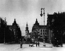
The origins of the street lie in the north of Berlin's historic centre. There were three alleys that went from the New Marketplace and St. Mary's Church at the northern end of the town down to the river Spree. They had had different names over the centuries and were ultimately known as Papenstraße (“bishops street”, named for a branch of the Bishopric of Havelberg), Brauhausstraße (“brewpub street”) and Kleine Burgstraße (“castle street”, named for the Stadtschloss on the other side of the river). Since the 16th century, a wooden bridge, known as Sechserbrücke (“sixpence bridge”), would lead across the water to Spree Island near the eastern terminus of Unter den Linden.
In the 1880s, it was decided to replace the pedestrian bridge with a much larger stone bridge and to combine the three alleys to a street that would effectively be an extension to the Unter den Linden boulevard. This new street became known as Kaiser-Wilhelm-Straße, named after the late German Emperor William I in 1888. It led from Spree Island across the new Kaiser-Wilhelm-Brücke through Old Berlin, turning slightly north at St. Mary's Church and ending at Münzstraße in the Scheunenviertel (“barns quarter”). In 1892 the street was extended to Hirtenstraße near modern Rosa-Luxemburg-Platz.[1]
Most of the buildings on Kaiser-Wilhelm-Straße were largely damaged and several lost completely in the British and American air raids on the city between 1943 and 1945 (see: Battle of Berlin (air)). In April 1945, German troops blew up the Kaiser-Wilhelm-Brücke in an attempt to hold back the Soviet advance in the Battle of Berlin.
After the war, the street became part of the Soviet sector of Berlin. It was renamed Liebknechtstraße in 1947 for Karl Liebknecht (1871–1919), co-founder of the Communist Party of Germany. The bridge to Spree Island was rebuilt in 1950 and equally named Liebknechtbrücke.[2]
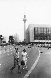
However, the lost buildings were only replaced in the 1960s when Mitte was rebuilt to fit the East German government's visions of a modern socialist city. The new Karl-Liebknecht-Straße started on Spree Island at the Marx-Engels-Platz, between the Berlin Cathedral and the Palace of the Republic. On the other side of Liebknechtbrücke, large Plattenbau apartment blocks were built. The right side of the street became a large open green at the foot of the Fernsehturm (TV tower). Instead of turning north at St. Mary's Church, the new Karl-Liebknecht-Straße now goes straight ahead to meet the arterial road Prenzlauer Allee at the former place of the city gate Prenzlauer Tor. The rest of the street, north of the church, is now known as Rosa-Luxemburg-Straße - named after Rosa Luxemburg, another co-founder of the Communist Party.
Unlike its surroundings, Karl-Liebknecht-Straße has not changed its look too much since the German reunification in 1990. However, plans for the reconstruction of the neighbourhood north of Alexanderplatz have been made.
| Name changes | |||||
| 16th century | Spreegäßlein | Zimmermannsgasse | Am Kramhause | Hinter der Badstube | |
| 17th century | Wasserstraße | Bolingsgasse | Papenstraße | Heinersdorfer Straße | |
| 18th century | Kleine Burgstraße | Klandersgasse | Papenstraße | Prenzlauer Straße | |
| 19th century | Kleine Burgstraße | Brauhausstraße | Papenstraße | Prenzlauer Straße | |
| 1887 | Kaiser-Wilhelm-Straße | Prenzlauer Straße | |||
| July 31, 1947 | Liebknechtstraße | Prenzlauer Straße | |||
| September 3, 1969 | Karl-Liebknecht-Straße + Rosa-Luxemburg-Straße | ||||
Route description
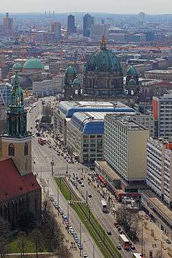
Karl-Liebknecht-Straße starts at the Schloßbrücke (“palace bridge”) on Spree Island as part of the German federal highways B 2 and B 5. On the left lies the Lustgarten, on the right Schloßplatz with the remains of the Palast der Republik. The street runs northeast, crosses the Liebknechtbrücke, leaving Spree Island, and meets Spandauer Straße, where the Bundesstraßen turn to the right. Karl-Liebknecht-Straße continues northeast, passing the Fernsehturm and Alexanderplatz through the old Königsstadt quarter to the border of Mitte borough. There, at the place of the old Prenzlauer Tor (“Prenzlau gate”) it crosses Torstraße and Mollstraße and continues as Prenzlauer Allee to the north of the city.
Buildings


At its start, Karl-Liebknecht-Straße passes two of the most prominent sites of Berlin, the evangelical Berlin Cathedral (official address: Am Lustgarten 1) and the former Palast der Republik (official address: Schloßplatz 1), which is currently being dismantled. In the future, probably starting in 2009 (2009 is the past, not the future), the Berlin City Palace will be rebuilt at this place.
Numbers 1 to 5 – DomAquarée
The numbers 1, 3, and 5 belong to the new DomAquarée building, completed in 2003. It houses several restaurants and shops as well as the Radisson SAS Hotel Berlin, the Sea Life Centre with the AquaDom aquarium and the GDR museum.
Number 8 – St. Mary's Church
At no. 8, there is the St. Mary's Church (St. Marienkirche), the second oldest church in the centre of Berlin and the oldest one still in use. It was first mentioned in 1292 as the church of Berlin's “new town”, right in front of the New Marketplace. Nowadays, St. Mary's is one of three churches of the Evangelical St. Mary's & St. Peter's parish, which has around 3,100 members.
Number 13 – Berlin Carré
Number 13, the northernmost part of a Plattenbau apartment block, holds the Berlin Carré, a shopping mall of about 7,600 m², which was built in 1969 to replace the Zentralmarkthalle (“central market hall”) at the same place.[3] In 2000, the cabaret theatre Sündikat (“sindicate”) also found a home in this building.
Number 29 – Pressehaus am Alexanderplatz
Number 29 is known as Pressehaus am Alexanderplatz, home of the Berliner Verlag, which publishes the popular Berliner Zeitung daily newspaper. The building also houses the Berliner Journalistenschule (“Berlin journalists school”), a college for the further education of journalists, which has its own radio and TV station.[4]
Former buildings
World War II and the subsequent reconstruction of East Berlin as the capital of the German Democratic Republic meant the end for several of Berlin's important and well-known buildings. The most prominent of course being the Stadtschloss (“city palace”). It was first built as a castle as early as 1443 under Frederick II, Elector of Brandenburg. It was largely rebuilt as a palace a hundred years later and became the family seat of the House of Hohenzollern, rulers of the Kingdom of Prussia and later of the German Empire. The building was demolished in 1950 on the order of the East German government. It was replaced by the Palast der Republik, which was demolished from 2006 until 2008, after the removal of asbestos.
Another well-known building was the elite school Joachimsthalsches Gymnasium, which had moved to the premises of the modern DomAquarée in 1650, after its old building in Joachimsthal had been destroyed in the Thirty Years' War. The school moved out of the building in 1880.
In 1886 the Zentralmarkthalle (“central market hall”) opened in two buildings left and right of the street, right at the railway tracks. It was built to replace the weekly markets at the Neuer Markt (“new marketplace”) at the foot of the St. Mary's Church, which had taken place for several centuries. The market hall survived the war, but was demolished in 1969 to make room for the current buildings.[5]
Another part of East Berlin's reconstruction program was the five-star Palasthotel (“palace hotel”) at Liebknechtbrücke. It was built between 1976 and 1979, based on a design by Ferenc Kiss. The hotel had 600 rooms with 1,000 beds and a conference hall with about 2,000 seats. It was closed for all East German guests, as one had to pay in a hard currency instead of the local East German mark. In 1992, the hotel was taken over by the Radisson group. It was demolished in 2000 to make room for the new DomAquarée, which was opened in 2003.[6]
Public transport
Karl-Liebknecht-Straße is serviced by five BVG bus lines with stops at Memhardstraße, Fernsehturm, St. Mary's Church and at Lustgarten. The lines are 100 between Alexanderplatz and Zoologischer Garten, 200 between Michelangelostraße and Zoologischer Garten, 248 between Alexanderplatz and Südkreuz, M48 between Alexanderplatz and Busseallee in Zehlendorf and the express bus TXL to Berlin-Tegel International Airport. The northern part of the street is also serviced by the tram line M2 with stops at Mollstraße and Memhardstraße. M2 connects Alexanderplatz and Heinersdorf (Pankow borough).
Footnotes
- ↑ "Kaiser-Wilhelm-Straße in Mitte" (in German). Edition Luisenstadt. Retrieved 4 April 2014.
- ↑ "Liebknechtbrücke - Berlin Lexikon" (in German). Edition Luisenstadt. 2002. Retrieved 4 April 2014.
- ↑ "Berlin Carré" (in German). Archived from the original on 1 July 2008. Retrieved 4 April 2014.
- ↑ "Die Schule Journalistenschule der Hauptstadt" (in German). Berliner Journalisten Schule. Archived from the original on 24 February 2011. Retrieved 4 April 2014.
- ↑ "Neuer Markt - Berlin.de". Berlin (in German). City of Berlin. Retrieved 4 April 2014.
- ↑ "Palasthotel, Berlin" (in German). DDR-Lexikon. Retrieved 4 April 2014.
Coordinates: 52°31′17″N 13°24′26″E / 52.52139°N 13.40722°E