Karkamış
| Karkamış | |
|---|---|
 Karkamış Location of Karkamış in Turkey | |
| Coordinates: 36°50′02.40″N 38°00′03.60″E / 36.8340000°N 38.0010000°ECoordinates: 36°50′02.40″N 38°00′03.60″E / 36.8340000°N 38.0010000°E | |
| Country |
|
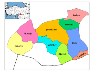
| Region | Southeastern Anatolia |
| Province | Gaziantep |
| Government | |
| • Mayor | Nuh Kocaaslan (AKP) |
| Area[1] | |
| • District | 309.89 km2 (119.65 sq mi) |
| Population (2012)[2] | |
| • Urban | 3,034 |
| • District | 10,587 |
| • District density | 34/km2 (88/sq mi) |
| Time zone | EET (UTC+2) |
| • Summer (DST) | EEST (UTC+3) |
| Postal code | 27xxx |
| Area code(s) | +(90)342 |
| Website | [3] |
Karkamış, aka Kargamış, is a town and district of Gaziantep Province in southeastern Turkey, next to the site of ancient Karkemish. The population of the town was 2,998 in 2010.
It is a border checkpoint on the road to Jarabulus in Syria. In 2004, 8,071 vehicles and 38,263 people passed the border checkpoint into Turkey while 8,795 vehicles and 35,474 people crossed it towards Syria.[4]
The River Euphrates runs east of Karkamış southwards into Syria. At this place, a railway bridge of 870 m (2,850 ft) that was built between 1911-1913 by German engineers as part of the Istanbul-Baghdad Railway, crosses the river parallel to the border line.[5]
One of the 21 dams of the Southeastern Anatolia Project (GAP), the Karkamış Dam and hydoelectric power station is located 4.5 km (2.8 mi) upstream from the border crossing of Euphrates.[6]
In March 2011, the Turkish military base which included Karkemish ruins was cleared of mines. Archaeologists from Italy and Turkey have begun excavations in the town in September 2011.[7]
History
The Municipality of Karkamış was established in 1961 (in fact it was called Barak at that time), before then having been assigned administratively under Nizip. At the time of the famous British Museum excavations at the nearby archaeological site lying to the East (1911–1914, 1920), Karkamış was not yet existing, only the railway station built by the Germans being already there, since the main village at that time was Jarabulus, now in Syria. After the Turkish War of Independence a settlement was established around the railway station which came to be named after the famous nearby archaeological site.
Archaeological heritage
The ancient site of Karkemish is now an extensive set of ruins, located on the West bank of Euphrates River, about 60 kilometres (37 mi) southeast of Gaziantep, Turkey and 100 kilometres (62 mi) northeast of Aleppo, Syria. The site is crossed by the Turco-Syrian border. A Turkish military base has been built on the Karkemish acropolis and Inner Town, and access to the site is restricted. Most of the Outer Town lies in Syrian territory.
_and_T.E.Lawrence_at_the_British_Museum's_Excavations_at_Carchemish%2C_Syria%2C_in_the_spring_of_1913.jpg)
Karkemish has always been well known to scholars because of several references to it in the Bible (Jer. 46:2; 2 Chr. 35:20; Isa. 10:9) and in Egyptian and Assyrian texts. However, its location was identified only in 1876 by George Smith.
The site was excavated by the British Museum, 1878-1881 by Patrick Henderson, 1911 by D. G. Hogarth and R. C. Thompson, and from 1912 to 1914 by C. L. Woolley, and T. E. Lawrence ("Lawrence of Arabia").[8][9][10] Excavations were interrupted in 1914 by World War I, resumed in 1920 with Woolley and then ended with the Turkish War of Independence.[11] These expeditions uncovered substantial remains of the Neo Hittite and Neo Assyrian periods, including defensive structures, temples, palaces, and numerous basalt statues and reliefs with Luwian hieroglyphic inscriptions.
Though the site was off limits to tourism until October 2014, following the completion in March 2011 of mine clearing operations on the Turkish portion of the site, archaeological work was resumed in September 2011 by a Turco-Italian joint archaeological expedition under the direction of Prof. Nicolò Marchetti of Bologna University.[12]
See also
References
- ↑ "Area of regions (including lakes), km²". Regional Statistics Database. Turkish Statistical Institute. 2002. Retrieved 2013-03-05.
- ↑ "Population of province/district centers and towns/villages by districts - 2012". Address Based Population Registration System (ABPRS) Database. Turkish Statistical Institute. Retrieved 2013-02-27.
- ↑ "[Yerelnet] Kargamiş İlçesi" (in Turkish). Yerelnet.org.tr. Retrieved 2012-10-30.
- ↑ "İdari Durum" (in Turkish). Karkamış Kaymakamlığı. Retrieved March 15, 2009.
- ↑ "Tarihi Fırat Demiryolu Köprüsü" (in Turkish). Karkamış Kaymakamlığı. Retrieved March 15, 2009.
- ↑ "Karkamış Barajı" (in Turkish). Karkamış Kaymakamlığı. Retrieved March 15, 2009.
- ↑ "Ancient city to rise in SE Turkey area cleared of mines". Hurriyetdailynews.com. Retrieved 2012-10-30.
- ↑ D.G. Hogarth, Carchemish I: Introductory, The British Museum Press, 1914, repr. 1969
- ↑ C.L. Woolley, Carchemish II: Town Defences: Report on the Excavations at Jerablus on Behalf of the British Museum, British Museum Press, 1921, repr. 1969, ISBN 0-7141-1002-7
- ↑ C.L. Woolley & R.D. Barnett, Carchemish III: Excavations in the Inner Town: Report on the Excavations at Jerablus on Behalf of the British Museum, British Museum Press, 1952, repr. 1978, ISBN 0-7141-1003-5
- ↑ H. G. Güterbock, "Carchemish", Journal of Near Eastern Studies, vol. 13, no. 2, pp. 102–114, 1954
- ↑ "Mine-clearing work in Karkamış nears completion". Todayszaman.com. 2010-12-05. Retrieved 2012-10-30.