Karatu District
| Karatu | |
|---|---|
| District | |
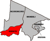 Map of Arusha Region's Districts with Karatu highlighted. | |
| Country | Tanzania |
| Region | Arusha Region |
| Population (2002) | |
| • Total | 178,434 |
Karatu District is one of the seven districts in the Arusha Region of Tanzania. It is bordered by the Ngorongoro District to the north, the Shinyanga Region to the west, the Monduli District to the east, and the Manyara Region to the south and southeast.
According to the 2002 Tanzania National Census, the population of the Karatu District was 178,434.[1]
Administrative subdivisions
Constituencies
For parliamentary elections, Arusha Region is divided into constituencies. As of the 2010 elections Arumeru District had one constituency, Karatu Constituency.
Wards
The Karatu District is administratively divided into thirteen wards:[1]
The Qurus ward is composed of 4 villages namely,
- Bashay
- Qurus
- Genda
- Gongali
A grassroots antipoverty program was developed in Gongali Village.[2]
Notes
- 1 2 "2002 Population and Housing General Report: Arusha: Karatu". Archived from the original on 18 March 2004.
- ↑ "What is Gongali model?".
Coordinates: 3°20′S 35°40′E / 3.333°S 35.667°E