Karatal River
| Karatal River | |
|---|---|
|
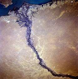
Satellite image of Karatal River delta as it enters Lake Balkhash, September 1996. The darker areas within the river valley floodplain are areas of irrigation. | |
|
Map of the Lake Balkhash drainage basin | |
| Country | Kazakhstan |
| Basin | |
| Main source | Dzungarsk-Alatau Mountains |
| River mouth | Lake Balkhash |
| Basin size | 19,100 km2 (7,400 sq mi) |
| Physical characteristics | |
| Length | 390 km (240 mi) |

The Karatal River (Russian: Каратал; Mongolian: Хартал, "Black Steppe"), also known as the Qaratal River, is a river in Kazakhstan that originates in the Dzungarian Alatau Mountains near the border of with China and flows into Lake Balkhash. It is the easternmost of two large rivers that flow into the lake; the other is the Ili River.[1] The Karatal is one of the main rivers of the historic region of Zhetysu.
The river flows west-south-west from the border with China before turning north-westward south of Taldykorgan and then northward when it reaches the Saryesik-Atyrau Desert, a large sand desert south of Lake Balkhash. The river empties into Lake Balkhash near the centerpoint of its southern side. Karatal freezes up in December and stays icebound until March. Because of irrigation, the river's flow into Lake Balkash is limited.[1]
References
- 1 2 STS-79 Shuttle Mission Imagery (STS079-781-100) NASA
External links
Coordinates: 46°28′31″N 77°13′07″E / 46.47528°N 77.21861°E