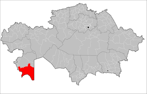
Karakiya District
| Karakiya | ||
|---|---|---|
| District | ||
| Қарақия ауданы | ||
| ||
 | ||
| Country | Kazakhstan | |
| Region | Mangystau Region | |
| Administrative center | Kuryk | |
| Population (2013)[1] | ||
| • Total | 32,304 | |
| Time zone | West (UTC+5) | |

Karakiya District (Kazakh: Қарақия ауданы, Qaraqïya awdanı, قاراقئيا اۋدانى) is a district of Mangystau Region in south-western Kazakhstan. The administrative center of the district is the selo of Kuryk.[2] Population: 32,304 (2013 estimate);[1] 29,579 (2009 Census results);[3] 23,437 (1999 Census results).[3]
References
- 1 2 "Население Республики Казахстан" (in Russian). Департамент социальной и демографической статистики. Retrieved 27 December 2013.
- ↑ www.geonames.de Subdivisions of Kazakhstan in local languages
- 1 2 "Население Республики Казахстан" (in Russian). Департамент социальной и демографической статистики. Retrieved 8 December 2013.
Capital: Aktau | ||
| Districts | 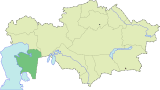 | |
| Major cities | ||
Coordinates: 43°12′N 51°39′E / 43.200°N 51.650°E
This article is issued from Wikipedia - version of the 6/20/2016. The text is available under the Creative Commons Attribution/Share Alike but additional terms may apply for the media files.