Karađoz Bey Mosque
| Karagöz Bey Mosque | |
|---|---|
 | |
| Basic information | |
| Location | Mostar, Bosnia and Herzegovina |
| Affiliation | Islam |
| Architectural description | |
| Architect(s) | Mimar Sinan |
| Architectural type | Mosque |
| Architectural style | Classical Ottoman |
| Completed | 1557 |
| Specifications | |
| Length | 13 metres (43 ft) |
| Width | 13 metres (43 ft) |
| Dome(s) | 1 |
| Dome height (outer) | 16.49 metres (54.1 ft) |
| Dome height (inner) | 15.89 metres (52.1 ft) |
| Dome dia. (outer) | 10.72 metres (35.2 ft) |
| Minaret height |
34.50 metres (113.2 ft)[1] 35.80 metres (117.5 ft)[2] |
| Materials | stone |
Karagöz Bey Mosque (Bosnian: Karađoz-begova džamija, Turkish: Karagöz Mehmed Bey Camii) is a mosque in the city of Mostar, Bosnia and Herzegovina.
With its big dome and high minaret it is the largest in the region.
History
Karagözbey Mosque was built in 1554[3] or 1557[4] by Mehmed Bey Karagöz (Mehmed-beg Karađoz), the brother of Ottoman vizier Rüstem Pasha. The plans for the mosque were drawn up by famed Turkish architect, Mimar Sinan.
The mosque was severely damaged during World War II, and faced near destruction during the Bosnian War in the early 1990s. However, Karagözbey Mosque, like the rest of Mostar, underwent extensive repairs between 2002 and 2004. The mosque was completely renovated, and reopened to the public in July 2004.
References
- ↑ "Karađoz-begova džamija, graditeljska cjelina" [Karagöz Bey Mosque, architectural complex] (in Bosnian). Commission for the Preservation of National Monuments of Bosnia and Herzegovina. 4 May 2004. Retrieved 19 January 2014.
- ↑ Čaušević, A.; Kuljuh, N.; Rustempašić, N. (2011). Brebbia, C. A.; Binda, L., eds. "Influence of mechanical properties on the stability and safety of masonry sacral towers structures". Structural Studies, Repairs and Maintenance of Heritage Architecture XII. Southampton, UK: WIT Press: 437.
|chapter=ignored (help) - ↑ "Karadjoz Beg Mosque". ArchNet Digital Library. Retrieved 12 January 2014.
- ↑ "Karađoz-begova džamija". Herzegovina-Neretva Tourism Board. Retrieved 12 January 2014.
| Banja Luka |  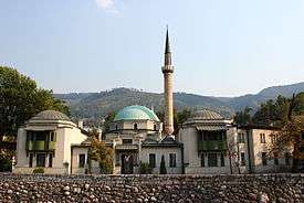 | |
|---|---|---|
| Mostar |
| |
| Sarajevo | ||
| Foča |
| |
| Other | ||
| ||
Coordinates: 43°20′28″N 17°48′50″E / 43.34111°N 17.81389°E