Karaahmetli, Erdemli
| Karaahmetli (İmirzeli) | |
|---|---|
| Village | |
 Karaahmetli Location in Turkey | |
| Coordinates: 36°33′N 34°08′E / 36.550°N 34.133°ECoordinates: 36°33′N 34°08′E / 36.550°N 34.133°E | |
| Country |
|
| Province | Mersin Province |
| District | Erdemli |
| Elevation | 600 m (1,970 ft) |
| Population (2012) | |
| • Total | 322 |
| Time zone | EET (UTC+2) |
| • Summer (DST) | EEST (UTC+3) |
| Postal code | 33730 |
| Area code(s) | 0324 |
| Licence plate | 33 |
Karaahmetli is village in Mersin Province, Turkey.
Geography
Karaahmetli is a village in Erdemli district of Mersin Province. Situated in the plateau to the south of Toros Mountains, at 36°33′N 34°07′E / 36.550°N 34.117°E, its distance to Erdemli is 26 kilometres (16 mi) to Erdemli and 62 kilometres (39 mi) to Mersin. The population of the village was 322 as of 2012.[1]
History
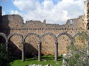
The village was probably founded by a Turkmen tribe in the Middle Ages, and the name of the village refers to the founder of the village. But the vicinity of the village is full of early Byzantine religious ruins, and the village may be described as an open-air museum. Especially the ruins of a 5th- or 6th-century church now called Emirzeli is an important example of Byzantine architecture.
Economy
Animal husbandry, which once constituted the major economic sector of the village, is on the decline. The main agricultural crops are tomato, cucumber, olice and some fruits.[2] Although the village hosts valuable archeological sites, at the moment, tourism plays no part in the village's economy.