Kaouar
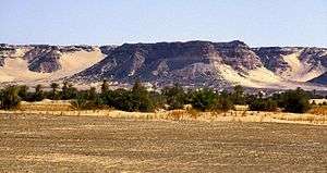
The Kaouar, or Kaouar Cliffs (Falaise Kaouar, Kaouar-tal) is a north-south escarpment running some 150 km (90 mi) in north east Niger. Surrounded by the Ténéré desert and the dunes of the Erg of Bilma, easterly winds striking the 100 meter high escarpment of Kaouar provide easy access to groundwater for ten oases on the leeward side. Its highest point is at the northern tip of the range: the Pic Zoumri at 576 metres (1,890 ft).
Running south to north, Bilma, Dirkou, Aney, and Séguédine are the largest towns.
The Kaouar oases are famous for salt and date production, and were along the route of the great Bornu to Fezzan caravan trail. This was the major point of contact between the African Sahel and the Mediterranean civilisations until the 19th century. Numerous archeological sites and rock paintings attest to human habitation here reaching back some 10,000 years to when the area was surrounded by lush grasslands.
In 1997, the Kaouar was submitted as a tentative candidate for UNESCO World Heritage Site status as part of The salt route from Air to Kaouar.[1]
References
- Decalo, Samuel (1979). Historical Dictionary of Niger. London and New Jersey: Scarecrow Press. ISBN 0-8108-1229-0.
- Geels, Jolijn (2006). Niger. Bradt London and Globe Pequot New York. ISBN 1-84162-152-8.
- Vikør, Knut S. (1996). The Oasis of Salt. The History of Kawar, a Saharan Centre of Salt Production. London.
External links
- Image galleries from the Kaouar.
- A traveler's experiences in the Kaouar, February-March 2001.
- Traveler's experiences in the Kaouar, by Tony and Elly van Gastel.
- Photo gallery from the Ténéré and the Kaouar.
Coordinates: 18°54′N 12°54′E / 18.900°N 12.900°E