Kantara Castle
| Kantara Castle | |
|---|---|
| (Greek: Κάστρο της Καντάρας Turkish: Kantara Kalesi) | |
 Kantara Castle | |
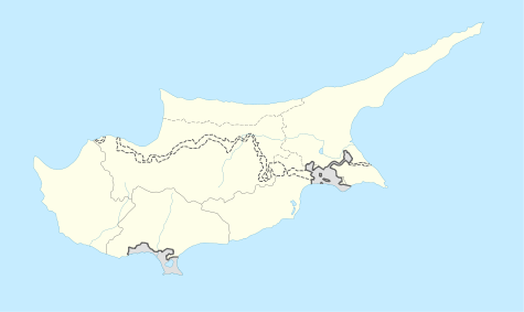 Location within Cyprus | |
| General information | |
| Architectural style | Medieval |
| Country |
de jure de facto |
| Coordinates | 35°24′23″N 33°55′24″E / 35.4064°N 33.9233°E |
| Construction started | 10th-century |
Kantara Castle is the easternmost of the three castles situated on the Kyrenia Mountain range in the island of Cyprus. (The other two are Buffavento and St Hilarion) Lying at 630 metres above sea level, Kantara is well positioned to control the entrances to Karpass Peninsula and Mesaoria plain. The name 'Kantara' is derived from the Arabic word qantara,[1] which means "bridge".
It is believed that the Byzantines built the castle in the 10th century as a lookout post against raiding Arabs.[2] The first historical mention of the castle is in connection with Richard the Lionheart's capture of Cyprus in 1191. At that time, Isaac Comnenus, the Byzantine ruler of the island, took refuge at Kantara Castle. Later, in 1228 the Royalists so badly battered the walls that they had to be almost entirely rebuilt. Later, the nobility used the castle as a lodge when they hunted mountain goats with tame leopards.
There is also a myth widely believed, that workers who were building the castle, when time came to get paid for their hard work, were thrown by the queen at the time from the window of her room. It is widely believed that this was done because the queen did not have enough money to pay the workers. Eventually, she committed suicide by jumping from the same window.
St. Hilarion supposedly visited the castle of Kantara in order to free the castle from the queen's evil spirit, that according to the villagers haunted the place. According to the myth, eventually St. Hilarion explained people that there are no evil spirits in castles but evil thoughts in people's hearts.
Also many mix this myth with St. Hilarion castle due to the man had visited and mentioned in the Kantara castle myth.
References

Coordinates: 35°24′23″N 33°55′24″E / 35.4064°N 33.9233°E