Kananga
| Kananga | |
|---|---|
|
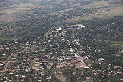
Kananga seen from the air, 2012 | |
 Kananga Location in Democratic Republic of the Congo | |
| Coordinates: 5°53′32″S 22°24′10″E / 5.89222°S 22.40278°E | |
| Country |
|
| Province | Kasai-Occidental |
| Founded | 1884 |
| Area | |
| • Total | 742,8 km2 (2,868 sq mi) |
| Elevation | 608 m (1,995 ft) |
| Population (2012) | |
| • Total | 1,061,181 |
| • Density | 140/km2 (370/sq mi) |
| Climate | Aw |
| National language | Tshiluba |
Kananga, formerly known as Luluabourg or Luluaburg, is the capitial city of Kasaï-Occidental Province and is intended as the capital of the proposed Lulua Province in the Democratic Republic of the Congo. It has a population of 463,556.[1]
The city lies near the Lulua River, a tributary of the Kasai River and the Ilebo-Lubumbashi railway. An important commercial and administrative centre, it is home to a museum and to Kananga Airport.
History
German explorer Hermann Wissmann established a station in the area around present-day Kananga, on the left bank of the Lulua. Wissmann named the station Malandji, a name suggested by his 400 carriers, who were from the city of Malanje in Angola. Later on, with the construction of the railway on the other bank of the river, the station was moved, and the Lulua train station gave its name to the new town, namely Luluabourg. The old location is named Malandji-Makulu (old Malandji) to this day.
At the Brussels Round Table, in 1960, the name given to the negotiations for the independence of the (then) Belgian Congo, a decision was taken that the new state would move the location of its capital from Kinshasa to Kananga (then Luluabourg), due to the latter's central location. However, due to multiple political setbacks, and particularly the secession attempt by Albert Kalonji and his South Kasai, this decision was never implemented. When the central government reconquered South Kasai in 1962, Luluabourg became the capital of the new Kasai-Occidental province. Kananga (as Luluabourg) was the site of the drafting of the first Congolese-written constitution for the Democratic Republic of the Congo, in 1964.
In 1966, during an Africanization campaign, Mobutu Sese Seko renamed a number of cities and towns that bore European names. Leopoldville became Kinshasa, and Luluabourg became Kananga. The name Kananga derives from the Tshiluba word kanangayi meaning "a place for peace or love" as what is now central Kananga was a gathering place for pre-colonial chiefs to discuss treaties and to settle disputes.
Under the 2006 constitution, the Democratic republic of the Congo was divided in 25 provinces, and one national Capital city (Kinshasa). The Kasai-Occidental was divided into two provinces. Kananga became the capital of the Lulua Province.
Locally, Kananga is known as Kananga-Malandji, or even Kananga-Malandji wa Nshinga. Nshinga, or cables, stands for the large high-voltage cables of the Inga-Shaba project, that cross the skies of Kananga, and that link Kolwezi and the Lualaba Province to the Inga Dam in Bas-Congo.
Climate
| Climate data for Kananga | |||||||||||||
|---|---|---|---|---|---|---|---|---|---|---|---|---|---|
| Month | Jan | Feb | Mar | Apr | May | Jun | Jul | Aug | Sep | Oct | Nov | Dec | Year |
| Average high °C (°F) | 29 (85) |
29 (85) |
30 (86) |
30 (86) |
31 (87) |
31 (88) |
29 (85) |
30 (86) |
29 (85) |
29 (85) |
29 (85) |
29 (84) |
30 (86) |
| Average low °C (°F) | 20 (68) |
20 (68) |
20 (68) |
20 (68) |
20 (68) |
18 (64) |
17 (63) |
19 (66) |
19 (67) |
20 (68) |
20 (68) |
20 (68) |
19 (67) |
| Average precipitation mm (inches) | 119 (4.7) |
114 (4.5) |
185 (7.3) |
155 (6.1) |
81 (3.2) |
13 (0.5) |
18 (0.7) |
50 (2) |
117 (4.6) |
147 (5.8) |
234 (9.2) |
206 (8.1) |
1,440 (56.7) |
| Source: Weatherbase [2] | |||||||||||||
Rail accidents
- 1 August 2007 - A railway accident 100 miles west of Kananga town, caused by a brake failure, resulted in 100 fatalities.[3]
- 29 November 2005 - People riding on roofs swept off by low beam of bridge.[4]
See also
References
- ↑ http://www.tiptopglobe.com/city?n=Kananga&p=463556#lat=-5.89583&lon=22.41780&zoom=7
- ↑ "Weatherbase: Historical Weather for Kananga, Democratic Republic of the Congo". Weatherbase. 2011. Retrieved on November 24, 2011.
- ↑ "DR Congo crash toll 'passes 100'". BBC News. 2 August 2007.
- ↑ http://www.masindian.com/news/news_main.asp?id=8365
External links
| Wikimedia Commons has media related to Kananga, Congo. |
- "Villes de RD Congo - Kananga" (in French). MONUC. 2006-05-29. Retrieved 2008-09-16.
Capitals of the provinces of the Democratic Republic of the Congo | ||
|---|---|---|
| ||
Provinces are shown between brackets | ||
Coordinates: 05°53.82′S 22°26.93′E / 5.89700°S 22.44883°E