Kamarupa
| Kamarupa Kingdom | ||||||||||||||||
| ||||||||||||||||
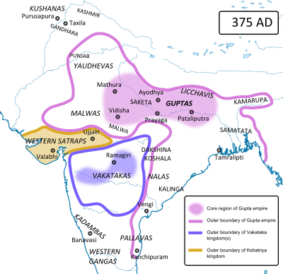 Kamarupta (in eastern India) and their contemporaries around 375 CE | ||||||||||||||||
| Capital | Pragjyotishpura Haruppeswara Durjaya | |||||||||||||||
| Government | Absolute monarchy, unitary state | |||||||||||||||
| Historical era | Classical Period | |||||||||||||||
| • | Established | 350 | ||||||||||||||
| • | Disestablished | 1140 | ||||||||||||||
| ||||||||||||||||
| Today part of | | |||||||||||||||
| Part of a series on the |
| Culture of Assam |
|---|
 |
|
Protohistoric
Ancient Medieval Colonial |
|
|
|
|
|
|
Festivals
|
| Religion |
|
History
Archives
Genres
Institutions Awards Asam Sahitya Sabha Award • Kamal Kumari Foundation Award • Krishnakanta Handique Award |
|
Music and performing arts |
|

Kāmarūpa (/ˈkɑːməˌruːpə/; also called Pragjyotisha), was one of the historical kingdoms of Assam that existed from 350 to 1140 CE. Ruled by three dyansty from their capitals in present-day Guwahati, North Guwahati and Tezpur, it at its height covered the entire Brahmaputra Valley, North Bengal, Bhutan and parts of Bangladesh, and at times portions of West Bengal and Bihar.[3]
Though the historical kingdom disappeared by 12th century to be replaced by smaller political entities, the notion of Kamarupa persisted and ancient and medieval chroniclers continued to call this region by this name.[4] Coins of Alauddin Hussain Shah, who invaded the Kamata Kingdom in the late 15th century, called the region Kamru or Kamrud. In the 16th century the Ahom kingdom came into prominence and assumed for itself the political and territorial legacy of the Kamarupa kingdom.[5]
The name of this kingdom survives in Kamrup, a present-day district in Assam.
Sources
Kamarupa and the northeast Indian region find no mention in the Ashokan records (3rd century BCE).[6] The first dated mention comes from the Periplus of the Erythraean Sea (1st century) where it describes a people called Sêsatai. The second mention comes from Ptolemy's Geographia (2nd century) calls the region Kirrhadia after the Kirata population.[7] The first mention of the kingdom comes from the 4th-century Allahabad inscription of Samudragupta that calls the kings of Kamarupa (Western Assam) and Davaka (now in Nagaon district) frontier rulers (pratyanta nripati).[8] The Chinese traveler Xuanzang visited the kingdom in the 7th century, then ruled by Bhaskar Varman.[9] The corpus of Kamarupa inscriptions left by the rulers of Kamarupa, including Bhaskar Varman, at various places in Assam and present-day Bangladesh are important sources of information. Nevertheless, local grants completely eschew the name Kamarupa; instead they use the name Pragjyotisha, with the kings called Pragjyotishadhipati.[10]
Boundaries
According to the 10th century Kalika Purana and the 7th century Xuanzang, the western boundary was the historical Karatoya River. The eastern border was the temple of the goddess Tamreshvari (Pūrvāte Kāmarūpasya devī Dikkaravasini, given in Kalika Purana) near present-day Sadiya[11] in the eastern most corner of Assam, which too agrees with Xuanzang.[12] The people of Kamarupa were aware of Sichuan which lay two months' journey away from its eastern borders.[13]
The southern boundary was near the border between the Dhaka and Mymensingh districts in Bangladesh. Thus it spanned the entire Brahmaputra valley and at various times included present-day Bhutan and parts of Bangladesh. This is supported by the various epigraphic records found scattered over these regions. The kingdom appears to have broken up entirely by the 13th century into smaller kingdoms and from among them rose the Kamata kingdom in the west and the Ahom kingdom in the east as the main successor kingdoms.
State
The extent of state structures can be culled from the numerous Kamarupa inscriptions left behind by the Kamarupa kings as well as accounts left by travellers such as those from Xuanzang.[14] Governance followed the classical saptanga structure of state.[15]
Kings and courts: The king was considered to be of divine origin. Succession was primogeniture, but two major breaks resulted in different dynasties. In the second, the high officials of the state elected a king, Brahmapala, after the previous king died without leaving an heir. The royal court consisted of a Rajaguru, poets, learned men and physicians. Different epigraphic records mention different officials of the palace: Mahavaradhipati, Mahapratihara, Mahallakapraudhika, etc.
Council of Ministers: The king was advised by a council of ministers (Mantriparisada), and Xuanzang mentions a meeting Bhaskaravarman had with his ministers. According to the Kamauli grant, these positions were filled by Brahmanas and were hereditary. State functions were specialized and there were different groups of officers looking after different departments.
Revenue: Land revenue (kara) was collected by special tax-collectors from cultivators. Cultivators who had no proprietary rights on the lands they tilled paid uparikara. Duties (sulka) were collected by toll collectors (kaivarta) from merchants who plied keeled boats. The state maintained a monopoly on copper mines (kamalakara). The state maintained its stores and treasury via officials: Bhandagaradhikrita and Koshthagarika.
Grants: The king occasionally gave Brahmanas grants (brahmadeya), which consisted generally of villages, water resources, wastelands etc. (agraharas). Such grants conferred on the donee the right to collect revenue and the right to be free of any regular tax himself and immunity from other harassments. Sometimes, the Brahmanas were relocated from North India, with a view to establish varnashramdharma. Nevertheless, the existence of donees indicate the existence of a feudal class. Grants made to temples and religious institutions were called dharmottara and devottara respectively.
Land survey: The land was surveyed and classified. Arable lands (kshetra) were held individually or by families, whereas wastelands (khila) and forests were held collectively. There were lands called bhucchidranyaya that were left unsurveyed by the state on which no tax was levied.
Administration: The entire kingdom was divided into a hierarchy of administrative divisions. From the highest to the lowest, they were bhukti, mandala, vishaya, pura (towns), agrahara (collection of villages) and grama (village). These units were administered by headed by rajanya, rajavallabha, vishayapati etc.[16] Some other offices were nyayakaranika, vyavaharika, kayastha etc., led by the adhikara. They dispensed judicial duties too, though the ultimate authority lay with the king. Law enforcement and punishments were made by officers called dandika, (magistrate) and dandapashika (one who executed the orders of a dandika).
Political history
 |
|
Rulers of Varman Dynasty (350 to 650 CE)
|
|
Rulers of Mlechchha Dynasty (650 to 900 CE)
|
|
Rulers of Pala Dynasty (900 to 1100 CE)
|
|
Major Events
|
Kamarupa, first mentioned on Samudragupta's Allahabad rock pillar as a frontier kingdom, began as a subordinate but sovereign ally of the Gupta empire around present-day Guwahati in the 4th century. It finds mention along with Davaka, a kingdom to the east of Kamarupa in the Kapili river valley in present-day Nagaon district, but which is never mentioned again as an independent political entity in later historical records. Kamarupa, which was probably one among many such state structures, grew territorially to encompass the entire Brahmaputra valley and beyond. The kingdom was ruled by three major dynasties, all of which drew their lineage from the legendary king Naraka, who is said to have established his line by defeating the aboriginal king Ghatakasura of the Danava dynasty.
Varman dynasty (c350–c650)
Pushyavarman (350–374) established the Varman Dynasty, by fighting many enemies from within and without his kingdom; but his son Samudravarman (374–398), named after Samudragupta, was accepted as an overlord by many local rulers.[17] Nevertheless, subsequent kings continued their attempts to stabilize and expand the kingdom.[18] Kalyanavarman (422-446) occupied Davaka and Mahendravarman (470-494) further eastern areas.[19] Narayanavarma (494–518) and his son Bhutivarman (518–542) offered the ashwamedha (horse sacrifice);[20] and as the Nidhanpur inscription of Bhaskarvarman avers, these expansions included the region of Chandrapuri visaya, identified with present-day Sylhet division. Thus, the small but powerful kingdom that Pushyavarman established grew in fits and starts over many generations of kings and expanded to include adjoining possibly smaller kingdoms and parts of Bangladesh.
After the initial expansion till the beginning of Bhutivarman's reign, the kingdom came under attack from Yasodharman (525–535) of Malwa, the first major assault from the west.[21] Though it is unclear what the effect of this invasion was on the kingdom; that Bhutivarman's grandson, Sthitavarman (566–590), enjoyed victories over the Gauda of Karnasuvarna and performed two aswamedha ceremonies suggests that the Kamarupa kingdom had recovered nearly in full. His son, Susthitavarman (590–600) came under the attack of Mahasenagupta of East Malwa. These back and forth invasions were a result of a system of alliances that pitted the Kamarupa kings (allied to the Maukharis) against the Gaur kings (allied with the East Malwa kings).[22] Susthitavarman died as the Gaur invasion was on, and his two sons, Suprathisthitavarman and Bhaskarvarman fought against an elephant force and were captured and taken to Gaur. They were able to regain their kingdom due probably to a promise of allegiance.[23] Suprathisthitavarman's regin is given as 595–600, a very short period, at the end of which he died without an heir.
Supratisthitavarman was succeeded by his brother, Bhaskarvarman (600–650), the most illustrious of the Varman kings who succeeded in turning his kingdom and invading the very kingdom that had taken him captive. Bhaskarvarman had become strong enough to offer his alliance with Harshavardhana just as the Thanesar king ascended the throne in 606 after the murder of his brother, the previous king, by Shashanka of Gaur. Harshavardhana finally took control over the kingless Maukhari kingdom and moved his capital to Kanauj.[24] The alliance between Harshavardhana and Bhaskarvarman squeezed Shashanka from either side and reduced his kingdom, though it is unclear whether this alliance resulted in his complete defeat. Nevertheless, Bhaskarvarman did issue the Nidhanpur copper-plate inscription from his victory camp in the Gaur capital Karnasuvarna (present-day Murshidabad, West Bengal) to replace a grant issued earlier by Bhutivarman for a settlement in the Sylhet region of present-day Bangladesh.[25]
In about 643, Xuanzang visited Bhaskarvarman's court and confirmed that the western border of the Kamarupa kingdom was the Karatoya River. At the end of this visit, Bhaskarvarman accompanied Xuanzang to Kanauj, and participated in a religious assembly and a festival at Prayaga (Allahabad) with Harshavardhana, spending more than a year away from his own kingdom. It seems Bhaskaravarman maintained relations with China. He recounted to Xuanzang a Chinese song about the Jin dynasty, which became very popular in his kingdom. After the death of Harsha, he helped a mission from China led by Wang Hiuen-ts'oe according to a Chinese account. Bhaskarvarman, also called Kumar, or Shri Kumar, was a bachelor king and died without an heir.
Mlechchha dynasty (c655–c900 CE)
After Bhaskaravarman's death without an heir, the kingdom passed into the hands of Salasthambha (655–670), an erstwhile local governor[26] and a member of an aboriginal group called Mlechchha (or Mech), after a period of civil and political strife. This dynasty too drew its lineage from the Naraka dynasty, though it had no dynastic relationship with the previous Varman dynasty. The capital of this dynasty was Haruppeshvara, now identified with modern Dah Parbatiya near Tezpur. The kingdom took on feudal characteristics[27] with political power shared between the king and second and third tier rulers called mahasamanta and samanta who enjoyed considerable autonomy.[28] The last ruler in this line was Tyāga Singha (890–900).
Pala dynasty (c900–c1100)
After the death of Tyāgasimha without an heir, a member of the Bhauma family, Brahmapala (900–920), was elected as king by the ruling chieftains, just as Gopala of the Pala dynasty of Bengal was elected. The original capital of this dynasty was Hadapeshvara, and was shifted to Durjaya built by Ratnapala, near modern Guwahati. The greatest of the Pala kings, Dharmapala had his capital at Kamarupanagara, now identified with North Guwahati. The last Pala king was Jayapala (1075–1100). Around this time, Kamarupa was attacked and the western portion was conquered by the Pala king Ramapala.
Non-dynastic Independent Kings
The Gaur king could not hold Kamarupa for long, and Timgyadeva (1110–1126) ruled Kamarupa independently for sometime. A minister of the Gaur king Kumarapala (the son of Ramapala) began an expedition against Timgyadeva and installed himself as a ruler at Hamshkonchi in the Kamrup region. Though he maintained friendly relationships with Kumarapala, he called styled himself after the Kamarupa kings issuing grants under the elephant seal[29] of erstwhile Kamarupa kings and assuming the title of Maharajadhiraja. The period saw a waning of the Kamarupa kingdom, and in 1205 the Afghan Muhammad-i-Bakhtiyar passed through Kamarupa against Tibet which ended in a disaster. Mughith al-Din Yuzbak of the Mameluk rulers of Bengal attacked and defeated an unknown ruler of Kamarupa in 1257. But Yuzbak could not hold on to the capital as he was weakened by the Monsoon rains that led to his defeat and death by the local population.
End of Kamarupa kingdom
The Kamarupa kingdom came to an end in the middle of the 13th century when a ruler of Kamarupanagara (Guwahati), named Sandhya, moved his capital to Kamatapur (North Bengal) and established the Kamata kingdom.[30] At that time, western Kamarupa was being ruled by the chiefs of the Bodo people, Koch and Mech tribes. In central Assam the Kachari kingdom was growing, and further east, the Sutiya kingdom. The Ahoms, who would establish a strong and independent kingdom later, began building their state structures in the region between the Kachari and the Sutiya kingdoms.
See also
Notes
- ↑ "Meet the Axomiya Sikhs". The Tribune. Chandigarh. 24 March 2013.
- ↑ (Lahiri 1991:26–28)
- ↑ (Sircar 1990:63–68)
- ↑ In the medieval times the region between the Sankosh river and the Barnadi river on the northern bank of the Brahmaputra river was defined as Kamrup (or Koch Hajo in Persian chronicles) (Sarkar 1990:95).
- ↑ (Guha 1983:24), and notes. Guha writes that from the 1530s when Tonkham, an Ahom general, pursued the defeated Turko-Afghan adventurers of Turbak to the Karatoya river, the traditional western boundary of the Kamarupa kingdom, '"the washing of the sword in the Karatoya" became a symbol of the Assamese aspiration, repeatedly evoked in the Bar-mels and mentioned in the chronicles."
- ↑ (Puri 1968, p. 4)
- ↑ Sircar, D. C., (1990) Chapter 5: Epico-Puranic Myths and Legends, pp 81
- ↑ (Sharma 1978, p. xv)
- ↑ Bhushan 2005, p. 21.
- ↑ "The name Kamarupa does not appear in local grants where Pragjyotisha alone figures with the local rulers called Pragjyotishadhipati." (Puri 1968, p. 3)
- ↑ "...the temple of the goddess Tameshwari (Dikkaravasini) is now located at modern Sadiya about 100 miles to the northeast of Sibsagar" (Sircar 1990, pp. 63–64).
- ↑ "To the east of Kamarupa, the description continues, the country was a series of hills and hillocks without any principal city, and it reached the to the southwest Barbarians [of China]" (Watters 1905, p. 186) Therefore, the hills to the east of Kamarupa could not have been the Karbi Hills because they do not reach to the southwest of China.
- ↑ "The pilgrim learned from the people [of Kamarupa] that the southwest borders of Szuchuan were distant about 2 months' journey, but the mountains and rivers were hard to pass, there were pestinential vapurs and poisonous snakes and herbs." (Watters 1905, p. 186)
- ↑ Choudhury, P. C., (1959) The History of Civilization of the People of Assam, Guwahati
- ↑ "We have reference to the component parts of the state (saptanga) as envisaged in the ancient texts." (Puri 1968, p. 56)
- ↑ (Puri 1968, p. 56)
- ↑ (Lahiri 1991:68)
- ↑ (Lahiri 1990:72) The Nagajari Khanikargaon rock inscription of 5th century found in Golaghat adduces the fact that the kingdom spread to the east very quickly.
- ↑ "As regards the eastern limits of the kingdom, Davaka was absorbed within Kamarupa under Kalyanavarman and the outlying regions were brought under subjugation by Mahendravarman." (Choudhury 1959, p. 47)
- ↑ (Sircar 1990:101)
- ↑ (Lahiri 1991:70). Though the first evidence is from the Mansador stone pillar inscription of Yasodharman, there is no reference to this invasion in the Kamarupa inscriptions.
- ↑ (Sircar 1990:106–107)
- ↑ (Sircar 1990:109)
- ↑ (Sircar 1990:113)
- ↑ (Sircar 1990:115)
- ↑ (Lahiri 1991:76)
- ↑ (Lahiri 1991:77–79)
- ↑ (lahiri 1991:78)
- ↑ In his Kamauli grant, Vaidyadeva used the Kamarupa royal seal with the elephant replaced by the Ganesha.
- ↑ (Kamarupa) was reorganized as a new state, 'Kamata' by name with Kamatapur as capital. The exact time when the change was made is uncertain. But possibly it had been made by Sandhya (c1250-1270) as a safeguard against mounting dangers from the east and the west. Its control on the eastern regions beyond the Manah (Manas river) was lax." (Sarkar 1992, pp. 40–41)
References
- Bhushan, Chandra (2005). Assam: Its Heritage and Culture. Gyan Publishing House. ISBN 978-81-7835-352-4.
- Choudhury, P. C. (1959). The History of Civilization of the People of Assam to the Twelfth Century AD. Department of History and Antiquarian Studies, Gauhati, Assam.
- Guha, Amalendu (December 1983), "The Ahom Political System: An Enquiry into the State Formation Process in Medieval Assam (1228–1714)", Social Scientist, 11 (12): 3–34, doi:10.2307/3516963
- Lahiri, Nayanjot (1991). Pre-Ahom Assam: Studies in the Inscriptions of Assam between the Fifth and the Thirteenth Centuries AD. Munshiram Manoharlal Publishers Pvt Ltd.
- Puri, Baij Nath (1968). Studies in Early History and Administration in Assam. Gauhati University.
- Sarkar, J N (1990), "Koch Bihar, Kamrup and the Mughals, 1576–1613", in Barpujari, H K, The Comprehensive History of Assam: Mediebal Period, Political, II, Guwahati: Publication Board, Assam, pp. 92–103
- Sarkar, J. N. (1992), "Chapter II The Turko-Afghan Invasions", in Barpujari, H. K., The Comprehensive History of Assam, 2, Guwahati: Assam Publication Board, pp. 35–48
- Sircar, D C (1990), "Pragjyotisha-Kamarupa", in Barpujari, H K, The Comprehensive History of Assam, I, Guwahati: Publication Board, Assam, pp. 59–78
- Sircar, D C (1990), "Political History", in Barpujari, H K, The Comprehensive History of Assam, I, Guwahati: Publication Board, Assam, pp. 94–171
- Sharma, Mukunda Madhava (1978). Inscriptions of Ancient Assam. Gauhati University, Assam.
- Watters, Thomas (1905). Davids, T. W. Rhys; Bushell, S. W, eds. On Yuan Chwang's Travels in India. 2. London: Royal Asiatic Society. Retrieved January 29, 2013.
| Wikimedia Commons has media related to Kamarupa Kingdom. |
| Protohistoric Assam | 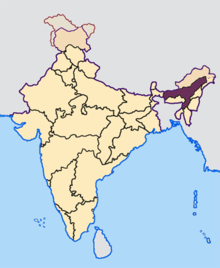 | |
|---|---|---|
| Ancient Assam | ||
| Medieval Assam | ||
| Colonial Assam | ||
| Contemporary Assam | ||