Kamarpukur
| Kamarpukur কামারপুকুর | |
|---|---|
| village | |
 Kamarpukur  Kamarpukur Location in West Bengal, India | |
| Coordinates: 22°55′N 87°39′E / 22.91°N 87.65°ECoordinates: 22°55′N 87°39′E / 22.91°N 87.65°E | |
| Country |
|
| State | West Bengal |
| District | Hooghly District |
| Government | |
| • Body | Gram panchayat |
| Population (2011) | |
| • Total | 3,121 |
| Languages | |
| • Official | Bengali, English |
| Time zone | IST (UTC+5:30) |
| PIN | 712612 |
| Telephone code | 03211 |
Kamarpukur is a village situated in Goghat II CD Block in the Arambag subdivision of the Hooghly District in West Bengal state of India. It is famous for being the birthplace of Ramakrishna. It is the block headquarters of the Goghat –II community development block.[1]
Geography
Kamarpukur is located at 22°55′N 87°39′E / 22.91°N 87.65°E.[2] A mile to the north of Kamarpukur, is situated the village of Bhursubo where a well-to-do person named Manik Raja lived. The renowned tanks of Sukhasayer and Hatisayer excavated by him as also the mango-grove now almost extinct in the nearby meadows, testify to some of his noteworthy acts.
On the western border of Kamarpukur, the canal Bhutir-Khal flows in a zigzag course from the north to the south and joins the Amodar river at a little distance.
Two cremation grounds called Budhui Moral and Bhutir-Khal lie on the north-east and north-west of the village respectively. Along the eastern border of the village a spacious road runs from Burdwan (32 miles from Kamarpukur) to Puri in Orissa.
To the south-east are the ruins of Fort Mandaran and the ancient temple of Saileswara Shiva, which bear witness to the prosperous days of the Pathan rulers.
About 30 miles to the east, is the famous temple of Tarakeswar Shiva, which is connected with Kamarpukur by a road running via Jahanabad (or Arambagh). Besides this, Ghatal (18 miles to the south) and Vishnupur (30 miles to the west) are joined with Kamarpukur by another road that abuts on the aforesaid road to Puri, after passing through the village via Kotulpur and Koalpara.
Three miles to the west, is Jayrambati, the village in which the Holy Mother Sri Sarada Devi was born.
Kamarkupur gram panchayat (GP) is a constituent GP of Goghat–II community development block in Arambag subdivision of the Hooghly district.[3] It is the block headquarters of the Goghat–II CD block.[1]
History
The signs of ancient prosperity are still visible everywhere at Kamarpukur. A number of ponds, tanks and old buildings and dilapidated temples still bear witness to its old glory. In olden days Kamarpukur, surrounded by extensive fields, looked like an island floating in a vast sea of green. Apart from agriculture, it was noted for cottage industries also. Sweet-meats like jilapi and nabat, hookah pipes of ebony, yarns, towels, cloth, etc., were prepared here and sent out for sale to Kolkata as well as to nearby markets. To this day, in the month of Chaitra (March—April), Kamarpukur reverberates with songs during the worship of Goddess Manasa and festival of Shiva, and in the following month, devotional choral songs of Hari are sung for three days at a stretch. Even now people belonging to the different strata of society live in peace in the tranquil atmosphere of the village.
Ramakrishna

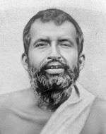
It was at Kamarpukur which is adorned with the beauty of nature and evergreens, that Sri Ramakrishna Paramahamsa was born in 1836 in a poor brahmin family. With his advent and on account of the frequent visits of his disciples and devotees, this hamlet has become a place of pilgrimage. Thousands visit it every year from the various parts of the world and get spiritually refreshed and elevated.
Through the help of the devotees and the management, and of the monks of the Ramakrishna Math and Ramakrishna Mission, the beautiful temple of Bhagavan Sri Ramakrishna, with his marble statue installed in it, was built in 1951 at Kamarpukur. With the construction of guest houses, a library, a dispensary and schools and the re-excavation of the tank called Haldarpukur, as also with the development of the surroundings, the place has really become one of the beauty-spots in the whole locality.
Vishalakshi Temple - Situated at Anur, around 2 km from Kamarpukur, goddess Vishalakshi is a very popular deity. People vow offerings to the goddess with the hope that the goddess will fulfil their desire. Not very long ago the goddess resided under the open sky at the place where the present temple is situated. Villagers were used to construct an ordinary leafy shed every year before the Makar Sankranti (Mid January) when a fair was organised. The tradition of the fair is being followed till today.
An interesting anecdote is associated with goddess Vishalakshi. Gadadhar (Sri Ramakrishna in his childhood) was accompanying a group of pious ladies in their way to offer worship to goddess Vishalakshi. When he was singing the glory of goddess Vishalakshi, suddenly his body became stiff and tears flowed down his cheeks. Seeing this ladies realised that it might be due to the mystic influence of the goddess on the simple hearted child. They immediately started praying to goddess Vishalakshi to save Gadadhar. Wonder! Gadadhar woke up with a brightened face.

Demographics
As per 2011 Census of India Kamarpukur had a total population of 3,121 of which 1,592 (51%) were males and 1,529 (49%) were females. Population below 6 years was 285. The total number of literates in Kamarpukur was 2,530 (89.21% of the population over 6 years).[4]
Education
Transport
The State Highway 7 (West Bengal) passes through Kamarpukur.[5]
References
- 1 2 "Contact details of Block Development Officers". Hooghly district. Panchayats and Rural Development Department, Government of West Bengal. Retrieved 2008-12-26.
- ↑ "Yahoo maps location of Kamarpukur". Yahoo maps. Retrieved 2008-12-21.
- ↑ "Directory of District, Sub division, Panchayat Samiti/ Block and Gram Panchayats in West Bengal, March 2008". West Bengal. National Informatics Centre, India. 2008-03-19. Retrieved 2008-12-26.
- ↑ "C.D. Block Wise Primary Census Abstract Data(PCA)". 2011 census: West Bengal – District-wise CD Blocks. Registrar General and Census Commissioner, India. Retrieved 10 June 2016.
- ↑ "List of State Highways in West Bengal". West Bengal Traffic Police. Retrieved 15 October 2016.
External links
- Kamarpukur Details
- Kamarpukur photos Childhood locations of Shri Ramakrishna Paramahamsa.
Cities, towns and locations in Hooghly District | |||||||||||||||
|---|---|---|---|---|---|---|---|---|---|---|---|---|---|---|---|
| Cities, municipal and census towns |
| ||||||||||||||
| Locations other than cities and towns | |||||||||||||||
| Related topics |
| ||||||||||||||
| Life |
|  | ||||||||||
|---|---|---|---|---|---|---|---|---|---|---|---|---|
| Philosophy |
| |||||||||||
| Disciples |
| |||||||||||
| Memorials | ||||||||||||
| Studies | ||||||||||||
| Bankura | 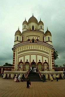 | |
|---|---|---|
| Bardhaman |
| |
| Birbhum |
| |
| Hooghly | ||
| Howrah | ||
| Jalpaiguri | ||
| Kolkata | ||
| Nadia |
| |
| North 24 Parganas |
| |
| Medinipur | ||
| Centres | ||