Kihei, Hawaii
| Kihei, Hawaii | |
|---|---|
| Census-designated place | |
|
Kīhei beach with the West Maui Mountains in the distance | |
 Location in Maui County and the state of Hawaii | |
| Coordinates: 20°45′33″N 156°27′26″W / 20.75917°N 156.45722°WCoordinates: 20°45′33″N 156°27′26″W / 20.75917°N 156.45722°W | |
| Country | United States |
| State | Hawaii |
| County | Maui |
| Area | |
| • Total | 11.7 sq mi (30.2 km2) |
| • Land | 9.3 sq mi (24.0 km2) |
| • Water | 2.4 sq mi (6.2 km2) |
| Elevation | 3 ft (1 m) |
| Population (2010) | |
| • Total | 20,881 |
| • Density | 1,800/sq mi (690/km2) |
| Time zone | Hawaii-Aleutian (UTC-10) |
| ZIP code | 96753 |
| Area code(s) | 808 |
| FIPS code | 15-36500 |
| GNIS feature ID | 0361181 |

Kīhei is a census-designated place (CDP) in Maui County, Hawaiʻi, United States. The population was 20,881 at the 2010 census.[1]
Geography
Kīhei is located at 20°45′33″N 156°27′26″W / 20.75917°N 156.45722°W (20.759122, −156.457228).[2]
According to the United States Census Bureau, the CDP has a total area of 11.7 square miles (30.2 km2), of which 9.3 square miles (24.0 km2) is land and 2.4 square miles (6.2 km2), or 20.44%, is water.[3] It is considered to be the South Side of Maui, located on the leeward side of Haleakala. The climate is arid, receiving no more than 10 inches (250 mm) of rain per year.
Demographics
As of the census[4] of 2000, there were 16,749 people, 6,170 households, and 3,813 families residing in the CDP. The population density was 1,648.6 people per square mile (636.5/km2). There were 9,170 housing units at an average density of 902.6 per square mile (348.5/km2). The racial makeup of the CDP was 47.76% White, 6.74% African American, 0.48% Native American, 24.72% Asian, 7.85% Pacific Islander, 1.58% from other races, and 16.87% from two or more races. Hispanic or Latino of any race were 1.52% of the population.
There were 6,170 households out of which 32.0% had children under the age of 18 living with them, 45.7% were married couples living together, 10.6% had a female householder with no husband present, and 38.2% were non-families. 25.7% of all households were made up of individuals and 4.0% had someone living alone who was 65 years of age or older. The average household size was 2.70 and the average family size was 3.31.
In the CDP the population was spread out with 25.1% under the age of 18, 8.1% from 18 to 24, 36.2% from 25 to 44, 23.6% from 45 to 64, and 7.0% who were 65 years of age or older. The median age was 35 years. For every 100 females there were 103.1 males. For every 100 females age 18 and over, there were 103.3 males.
The median income for a household in the CDP was $46,215, and the median income for a family was $50,738. Males had a median income of $33,229 versus $26,881 for females. The per capita income for the CDP was $21,591. About 7.0% of families and 10.1% of the population were below the poverty line, including 8.8% of those under age 18 and 5.1% of those age 65 or over.
Research
Several research facilities are located in Kihei, including the main offices for the Hawaiian Islands Humpback Whale National Marine Sanctuary,[5] seed operations by DEKALB Genetics Corporation and Monsanto Company,[6] and the Maui Research and Technology Park, which is home to the Maui High Performance Computing Center (MHPCC), and the Pacific Disaster Center[7] and is overseen by the Air Force Maui Optical and Supercomputing observatory (AMOS).
Economy
Major employers in Kihei include Safeway, Monsanto, the, Hawai'i Department of Education, the Kihei Canoe Club, Keller Williams Realty Maui, Goodfellow Bros., Fred's Mexican Cafe, and NextHome Pacific Properties.[8]
Gallery
 Kamaole Beach Park, looking north
 Kamaole Beach Park, looking south
References
- ↑ "Profile of General Population and Housing Characteristics: 2010 Demographic Profile Data (DP-1): Kihei CDP, Hawaii". U.S. Census Bureau, American Factfinder. Retrieved December 28, 2011.
- ↑ "US Gazetteer files: 2010, 2000, and 1990". United States Census Bureau. 2011-02-12. Retrieved 2011-04-23.
- ↑ "Geographic Identifiers: 2010 Demographic Profile Data (G001): Kihei CDP, Hawaii". U.S. Census Bureau, American Factfinder. Retrieved December 28, 2011.
- ↑ "American FactFinder". United States Census Bureau. Retrieved 2008-01-31.
- ↑ "NOAA Breaks Ground on New Facility at Hawaiian Islands Humpback Whale National Marine Sanctuary Office in Kihei". www.publicaffairs.noaa.gov. Retrieved 2008-04-06.
- ↑ Monsanto - Hawaii > Farm Stations
- ↑ "Maui Research and Technology Park Tenants".]
- ↑ Search Results - Kihei, Hawaii - ReferenceUSA Current Businesses
External links
 Media related to Kihei, Hawaii at Wikimedia Commons
 Kihei travel guide from Wikivoyage
Islands, municipalities, and communities of Maui County, Hawaii, United States | ||
|---|---|---|
| CDPs | 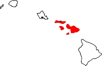 | |
| Unincorporated communities | ||
| Footnotes | ‡This populated place also has portions in an adjacent county or counties | |