Kalsubai
| Kalsubai | |
|---|---|
 Kalsubai, highest peak in Maharashtra. | |
| Highest point | |
| Elevation | 1,646 m (5,400 ft) |
| Prominence | 1000 m |
| Listing | List of Indian states and territories by highest point |
| Coordinates | 19°36′04″N 73°42′33″E / 19.60111°N 73.70917°ECoordinates: 19°36′04″N 73°42′33″E / 19.60111°N 73.70917°E |
| Geography | |
 Kalsubai Location of Kalsubai, Maharashtra | |
| Location | Border of Igatpuri Taluka, Nashik district and Akole Taluka, Ahmednagar district, Maharashtra, India |
| Parent range | Western Ghats |
| Geology | |
| Age of rock | Cenozoic |
| Mountain type | Flood basalt |
| Type of rock | Basalt and Laterite |
| Climbing | |
| Easiest route | Hiking |
Kalsubai (Marathi: कळसूबाई शिखर) is a mountain (1646 meters) of the Western Ghats range located in the Indian state of Maharashtra. Its summit situated at an elevation of 5400 feet is the highest point in Maharashtra which earns it the much glorified title of the 'Everest of Maharashtra'.[1]
The mountain range lies within the Kalsubai Harishchandragad Wild-life Sanctuary. It is visited throughout the year by avid trekkers, kalsubai temple devotees and wild-life enthusiasts alike.
Geology
The mountain range was formed by the same historical events [2] that gave birth to the Western Ghats. Resting on the Deccan Plateau geologically identified as a large igneous province, it consists of solidified Flood basalt dating back to the Cenozoic era.[3]
Geography and topography
The peak along with the adjoining hills spans along a downward-slanting east to west axis eventually merging with the formidable escarpment of the western ghats at almost right angles.Along its length they form a natural boundary demarcating the Igatpuri Taluka, Nashik district at its north from the Akole Taluka, Ahmednagar district at its south.The mountain itself lies on the Deccan Plateau with its base at an elevation of 587 meters (1926 feet) above mean sea level.[4] The mountain along with adjoining hills forms an enormous catchment area for the Arthur Lake which it overlooks.
Reaching Kalsubai
The mountain can be viewed, in its entirety, from Bari village located on its eastern side,about six km from Bhandardara. It can be reached by road, via Igatpuri on the Mumbai-Nasik route. Trains leaving from Mumbai provide an alternate mode of transport till Kasara railway station with connecting State transport buses, plying on the Akole-Kasara route, leading up to the base village. Private vehicles from Kasara provide yet another alternative to public transport.
Trekking
The peak attracts a large number of trekkers and devotees determined to scale the mountain.To reach the summit there are well designated trekking routes.The most popular route is through the eastern mountain face taking off from the base village Bari. The Waki river, a tributary of Pravara, takes origin on its eastern slope and flows as a stream through the outer fringes of Bari. A short distance away from the stream a Hanuman temple has been built. This provides an important landmark to commence the trek as well as a resting post for those nearing the final lap of their trek. The route from behind this temple takes the hiker straight to the summit. The trek along this route is a mix of easy to ascend slopes as well as treacherous rocky outcrops overlooking the valley below. Considering the increasing foot fall in recent years, the government has built iron ladders along the vertical hill slopes. These assist trekkers to allow for a convenient and safe ascent.
The route via Indore is relatively unexplored as not many people are aware of it. Unlike the regular route via Bari, which has fixed ladders, cemented steps and several people flocking during the monsoon, the route via Indore is raw with stone steps and a huge iron chain for support at the dangerous patches.[5]
Kalsubai temple

The truncated summit provides a modest area of flat land which holds a sacred temple of a local deity. Local legend[6] says that kalsubai was a house maid residing in a nearby Indorey village. She is believed to have disappeared near the mountain while trying to escape her employer's relentless torment. This lends the mountain its current name as well as a reason for this temple to be built in her fond memory.
A traditional prayer service is held every Tuesday and Thursday by a priest. During the festival of Navratri a fair comes to be organized each year with many stalls being set up near the summit to provide pooja materials to the devotees. On these special occasions local villagers participate in this fair which helps to supplement their livelihood and as well as provides them an opportunity to revere the mountain.
Ecology
Kalsubai comes to be protected under the precincts of a sanctuary.It nurtures nature in the vast stretches of forests nestled along their slopes and valleys. Open high-altitude forests dominate the scene. In the post-monsoon period the region witnessnes a dramatic makeover with flowers of different colors and varieties blossoming along the landscape. This attracts hoard of butterflies,bees, dragon-flies and other insects to feed upon the precious nectar.
During winter mornings, reptiles like lizards and snakes could be spotted sun-bathing near the ladders.kalsubai is one of the peace point in maharashtra.
Places of Interest
Bhandardara Dam, located 6 km away, impounds the Pravara river to form the Arthur Lake.[7]
Arthur Lake: The clear and placid lake is bounded by thick canopied forests of the Sahyadri hills. The Lake gets its water from the Pravara River. It also attracts one's attention from the summit.
Umbrella falls are formed as water from the Arthur e is released periodically to drain downstream.
To the north of the mountain range forts such as Ramsej, Harihargad, Brahmagiri, Anjaneri, Ghargad, Bahula, Tringalwadi, Kavnai can be seen. To the east one can spot Aundha, Vishramgad, Bitangad, to the west Alang, Madangad, Kulang, Ratangad (south west) and to the south Pabhargad, Ghanchakkar, Harishchandragad can be seen.
Culture & News
Touted as the most unusual wedding, on 28 December 2014, in the presence of close family members, a couple tied knot at the temple situated on the summit.[8]
Celebrations for India's 69th Independence Day took place at the summit where the Navy unfurled the largest flag of India measuring 60 feet in length and 40 feet in breadth.[9]
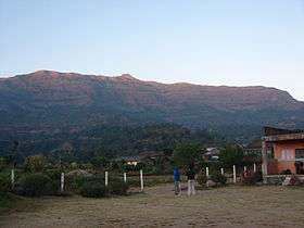
Photo Gallery
-

Kalsubai.
-
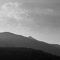
Peak of Kalsubai photographed in late evening.
-

Kalasubai steps to reach on top
See also
- List of mountain peaks of Maharashtra
- List of Indian states and territories by highest point
- Salher
- Sahyadris
References
- ↑ Sharma, Sudhir (2013-10-06). "Kalsubai – The Everest of Maharashtra | TravelPlay". Travelplay.in. Retrieved 2016-02-27.
- ↑ "Geological Survey of India(GSI),Ministry of Mines,Government of India - Indian Geology - Deccan Basalt Volcanism". Portal.gsi.gov.in. Retrieved 2016-02-27.
- ↑ "What really killed the dinosaurs? Before an asteroid wiped out the dinosaurs, Earth experienced a short burst of intense volcanism." Jennifer Chu | "MIT News Office," December 11, 2014
- ↑ "Bari Village , Akole Taluka , Ahmednagar District". Onefivenine.com. Retrieved 2016-02-27.
- ↑ Avril-Ann Braganza (2014-06-25). "Discover new trekking routes this monsoon | Latest News & Updates at Daily News & Analysis". Dnaindia.com. Retrieved 2016-02-27.
- ↑ "Kalsubai". Ahmednagar.gov.in. Retrieved 2016-02-27.
- ↑ Ismat Tahseen (2010-06-17). "24 hour monsoon getaways | Latest News & Updates at Daily News & Analysis". Dnaindia.com. Retrieved 2016-02-27.
- ↑ Anu James (2014-12-29). "Unusual Wedding: Couple Marries on Top of Maharashtra's Tallest Peak Mt Kalsubai [PHOTOS]". Ibtimes.co.in. Retrieved 2016-02-27.
- ↑ "Navy to Unfurl Massive Tricolour at Highest Point in Maharashtra". Ndtv.com. 2015-08-15. Retrieved 2016-02-27.
External links
| Topics | |||||||||||||||||||||||
|---|---|---|---|---|---|---|---|---|---|---|---|---|---|---|---|---|---|---|---|---|---|---|---|
| Regions | |||||||||||||||||||||||
| Divisions and Districts |
| ||||||||||||||||||||||
| Million-plus cities in Maharashtra | |||||||||||||||||||||||
| Other cities with municipal corporations | |||||||||||||||||||||||
Portal: Maharashtra | |||||||||||||||||||||||