Kaita, Nigeria
| Kaita | |
|---|---|
| LGA and town | |
 Kaita Location in Nigeria | |
| Coordinates: 13°04′50″N 7°45′14″E / 13.08056°N 7.75389°ECoordinates: 13°04′50″N 7°45′14″E / 13.08056°N 7.75389°E | |
| Country |
|
| State | Katsina State |
| Area | |
| • Total | 925 km2 (357 sq mi) |
| Population (2006 census) | |
| • Total | 184,401 |
| Time zone | WAT (UTC+1) |
| 3-digit postal code prefix | 820 |
| ISO 3166 code | NG.KT.KT |
Kaita is a Local Government Area in Katsina State, Nigeria, sharing a border in the north with the Republic of Niger. Its headquarters are in the town of Kaita.
There are many villages under Kaita that are traditionally headed by District Heads or Magaddai as they are called in Hausa. The villages serve as wards and so produce the local government councillors.
Prominent among these villages include Dankama, Girka, Dutsen Safe, Yandaki and Yanhoho.
It has an area of 925 km² and a population of 184,401 at the 2006 census.
The postal code of the area is 820.[1]
References
- ↑ "Post Offices- with map of LGA". NIPOST. Retrieved 2009-10-20.
State capital: Katsina | ||
| LGAs | 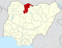 | |
This article is issued from Wikipedia - version of the 7/28/2013. The text is available under the Creative Commons Attribution/Share Alike but additional terms may apply for the media files.