Kahl (river)
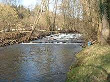 | |
| Kahl in Alzenau. | |
| Location | Bavaria, Hesse, |
|---|---|
| Reference no. | DE: 24772 |
| Length | 32.4 km [1] |
| Source | near Kleinkahl 50°07′17″N 9°18′59″E / 50.121444°N 9.3163311°ECoordinates: 50°07′17″N 9°18′59″E / 50.121444°N 9.3163311°E |
| Mouth | in Kahl into the Main 50°03′59″N 8°59′29″E / 50.066361°N 8.9914512°E |
| Basin | Rhine |
| Progression | Main → Rhine → North Sea |
| Catchment | 198.35 km² [2] |
| Discharge | Average mid: 1.89 m³/s[3] |
The Kahl is a river in the northern Spessart in Bavaria and Hesse, Germany. It is a right tributary of the Main and is 32 km (19.9 mi) long. The name Kahl comes from the Old High German word kaldaha, which means cool and clear. The Kahl rises from two sources left and right of the road at the foot of the Spessart hills, near Kleinkahl. These springs produce 50–60 litres per second. The Kahl flows into the river Main in Kahl am Main. The mouth is near the old Kahl Nuclear Power Plant. The largest tributaries are Westerbach, Sommerkahl, Reichenbach and Geiselbach.
Tributaries
Tributaries from source to mouth:
|
Left
|
Right
|
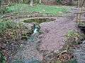 The right spring of the Kahl
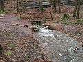 The left spring
 Mouth in the river Main
References
- ↑ Kartenservices der Bayrischen Landesamtes für Umwelt
- ↑ Hochwasser Aktionsplan Main
- ↑ Hochwassernachrichtendienst Bayern
| Wikimedia Commons has media related to Kahl. |
This article is issued from Wikipedia - version of the 6/15/2016. The text is available under the Creative Commons Attribution/Share Alike but additional terms may apply for the media files.