Kadapa
| Kadapa కడప Cuddapah | |
|---|---|
| City | |
|
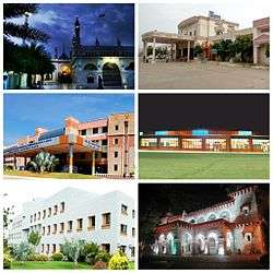
Montage of Kadapa city. clockwise from Top Left: Ameen peer Dargha, Railway Station, Airport, British Era Collectorate Building, YVU Kadapa, RIMS Kadapa | |
 Kadapa | |
| Coordinates: 14°28′N 78°49′E / 14.47°N 78.82°ECoordinates: 14°28′N 78°49′E / 14.47°N 78.82°E | |
| Country | India |
| State | Andhra Pradesh |
| Region | Rayalaseema |
| District | Kadapa |
| Founded | 1808 AD |
| Government | |
| • Type | Mayor–Council |
| • Body | Kadapa Municipal Corporation |
| • MP | Y. S. Avinash Reddy |
| • MLA | Amzath Basha S.B |
| • Mayor | Kothamaddi Suresh Babu |
| • Municipal Commissioner | P.Chandramouliswara Reddy[1] |
| Area[2] | |
| • City | 164.08 km2 (63.35 sq mi) |
| Area rank | 4th (in AP) |
| Elevation | 138 m (453 ft) |
| Population (2011)[3] | |
| • City | 343,054 |
| • Rank |
130th (India) 6th (Andhra Pradesh) |
| • Density | 2,100/km2 (5,400/sq mi) |
| • Metro[4] | 344,893 |
| Languages | |
| • Official | Telugu |
| Time zone | IST (UTC+5:30) |
| PIN | 516001,002,003,004[5] |
| Telephone code | 08562[6] |
| Vehicle registration | AP-04 |
| Website | Kadapa Municipal Corporation |
Kadapa (formerly known as Cuddapah) is a city in the Rayalseema region of the south-central part of Andhra Pradesh, India. It is the district headquarters of YSR Kadapa district. As of 2011 Census of India, the city had a population of 344,078. It is located 8 kilometres (5.0 mi) south of the Penna River. The city is surrounded on three sides by the Nallamala and Palakonda hills lying on the tectonic landscape between the Eastern and Western ghats. Black and Red ferrous soils occupy the region. The city is nicknamed "Gadapa" ('threshold') since it is the gateway from the west to the sacred hills of Tirumala.
Kadapa has been under the rule of different kingdoms, including the Cholas, the Vijayanagara Empire. It is also well known for its spicy and culinary food.
Etymology
The city's name originated from the Telugu word "Gadapa" meaning threshold or gate. It acquired this name with its relation to the Tirumala Hills; one had to pass through Cuddapah in olden days to reach Tirumala Hills. In old Telugu the word Kadapa meant a threshold which in modern standard Telugu is evolved to gadapa while the city's name retained the old flavour. It was spelled "Cuddapah" but was changed to "Kadapa" on 19 August 2005 to reflect the local pronunciation of the name.[7]
History
Post classical era (200-800 AD)
The history of Kadapa dates back to the 2nd century BC. The evidences of Archaeological Survey of India suggest that it started with Mourya and Satavahana dynasty. And since then it has remained battle field for numerous dynasties including Chalukya, Cholas and Pallava. Among all of these dynasties, first one to rule over Kadapa was Pallava dynasty. Pallava kings ruled over the city during the 5th century after penetrating into North of Kadapa. After that Cholas ruled till the 8th century after defeating Pallavas. Later Banas came into existence as the next dynasty to rule over Kadapa.[8]
Medieval Era (8th to 18th centuries AD)
After Banas, Rashtrakutas ruled Kadapa region Among the popular rulers of Kadapa was King Indra III, who served during the period of 915 AD. In his period, Kadapa gained a lot of power and influence, which declined with his death later. Telugu Cholas, were the next one to rule Kadapa. Ambadeva ruled Kadapa in the latter half of the 13th century when he established the capital at Vallur, which is located at a distance of about 15 km from Kadapa.
After the death of Ambadeva, Kakatiya king Prataparudra II ruled until early 14th century. Prataparudra was defeated by Muslims in the reign of Khilji emperor Alla Uddin. Later in the mid-14th century, Hindus of Vijayanagar dynasty drove the Muslims out of Warangal and subsequently Kadapa and ruled for around two centuries till they were defeated by the Nawab of Golkonda. The most illustrious ruler during this time was Pemmasani Thimma Nayudu (1422 CE) who developed the region and constructed many tanks and temples here. Muslims of Golkonda conquered the region in 1594 when Mir Jumla II raided Gandikota fort and defeated Chinna Thimma Nayudu by treachery. Marathas took over the city in 1740 after defeating the Nawab of Kurnool and Cuddapah. Hyder Ali also ruled the city before it fell in the hands of Nizam by the treaties of Mysore and Srirangapatnam.[9] Later the British took control of Kadapa District in 1800 CE. Although the town is an ancient one, it was probably extended by Neknam Khan, the Qutb Shahi commander, who called the extension as "Neknamabad". The name "Neknamabad" was used for the town for some time but slowly fell into disuse and the records of the 18th century refer to the rulers not as Nawabs of basireddy but Nawabs of Kadapa. Except for some years in the beginning, Kadapa District was the seat of the Mayana Nawabs in the 18th century. With the British occupation of the tract in 1800 CE it became the headquarters of one of the four subordinate collectorates under the principal collector Sir Thomas Munro. Monuments from the rule of the Kadapa District Nawabs are still found in the town. Most prominent among these are two towers and the dargahs. In 2004, Kadapa was recognised as a municipal corporation.[10]
Geography
Topography
Kadapa is located at 14°28′N 78°49′E / 14.47°N 78.82°E about 412 km from Hyderabad, in the Rayalaseema region of Andhra Pradesh.[11] The city is situated in the Bugga or Ralla Vanka bordered by the Palakondas to the south and to the east by a patch of hills casting north for the Lankamalas on Penna's other side.[12] It has an average elevation of 138 metres (452 ft).[13] The hills of western and eastern ghats stand on either sides, shielding it from the extreme winds of summer and winter
Climate
Kadapa has a tropical wet and dry climate characterised by year round high temperatures. It has a record of reaching more than 50 degree Celsius. Summers are especially uncomfortable with hot and humid climate. During this time temperatures range from a minimum of 34°C and can rise up to a maximum of 40°C. Temperatures are range in the mid thirties during the day. Humidity is around 75% during the summer months. Monsoon season brings substantial rain to the area. Kadapa gets rainfall from both the South west monsoon as well as the North East Monsoon. June to October is usually the monsoon. Winters are comparatively milder and the temperatures are lower after the onset of the monsoons. During this time the temperatures range from a maximum of 25°C and can rise up to a maximum of 35°C. Humidity is much lower during the winter season. Winter season is the best time to visit the place.[14]
| Climate data for Kadapa, Andhra Pradesh | |||||||||||||
|---|---|---|---|---|---|---|---|---|---|---|---|---|---|
| Month | Jan | Feb | Mar | Apr | May | Jun | Jul | Aug | Sep | Oct | Nov | Dec | Year |
| Average high °C (°F) | 30.8 (87.4) |
34.2 (93.6) |
37.6 (99.7) |
39.7 (103.5) |
40.1 (104.2) |
36.9 (98.4) |
35.0 (95) |
34.0 (93.2) |
33.4 (92.1) |
32.4 (90.3) |
30.3 (86.5) |
29.3 (84.7) |
34.48 (94.05) |
| Average low °C (°F) | 19.1 (66.4) |
20.9 (69.6) |
23.8 (74.8) |
27.3 (81.1) |
28.6 (83.5) |
26.8 (80.2) |
25.7 (78.3) |
25.4 (77.7) |
25.0 (77) |
23.8 (74.8) |
21.2 (70.2) |
19.0 (66.2) |
23.88 (74.98) |
| Average precipitation mm (inches) | 0 (0) |
1 (0.04) |
5 (0.2) |
17 (0.67) |
48 (1.89) |
76 (2.99) |
121 (4.76) |
114 (4.49) |
133 (5.24) |
148 (5.83) |
67 (2.64) |
23 (0.91) |
753 (29.66) |
| Source: Climate-Data.org[15] | |||||||||||||
Demographics
| Kadapa population | |||
|---|---|---|---|
| Census | Pop. | %± | |
| 1961 | 49,027 | — | |
| 1971 | 66,195 | 35.0% | |
| 1981 | 103,125 | 55.8% | |
| 1991 | 121,463 | 17.8% | |
| 2001 | 287,093 | 136.4% | |
| 2011 | 344,893 | 20.1% | |
| Kadapa Municipal Corporation | |||
Kadapa is one of the largest and fastest developing cities in Andhra Pradesh. As per the 1991 census the population of the town was 1,21,463. It didn't increase much as per the 2001 census which recorded 1,26,505 lakhs for 20 wards population with an average decadal growth rate of 0.36 per cent.[17] Later it was converted to a Municipal Corporation in 2005. As per provisional data of 2011 census, Kadapa urban agglomeration has a population of 344,078, out of which males are 172,969 and females are 171,109. The literacy rate is 79.34 per cent. The urban population has 65% Hindus, 32% Muslims and 3% Christians.-[18][19]
Languages
Telugu is the official and largest spoken language in the city. Most of the Muslims speak Urdu. Hindi is also spoken in many areas of the city among North Indian traders. English is gaining popularity day by day in the city due to the development.
Administration
Local Government
The Kadapa Municipal Corporation oversees the civic needs of the city and was constituted in the year 2005. It has 50 municipal wards represented by a corporator through direct election, who in turn elects the Mayor.[20] The District court is located in the city itself.
Culture
The city has rich culture and heritage with the influence of different dynasties. There are different rituals, customs and traditions with the existence of different religions such as, Hinduism, Islam, Christianity, Buddhism and Jainism.
Arts and crafts
Shilparamam is a crafts village situated in the outskirts of Kadapa.[21]
Cuisine
Kadapa is well known for its spicy and culinary food which is very similar to the South Indian food. People have idly, sambar and chutney in their breakfast. Rice, daal and curry is usually served as lunch. Most of the restaurants serve South Indian thali including these dishes in their lunch and dinner menu. Although it has a South Indian touch in its dishes it also has a diverse variety of its own which include Ragi Sangati or Ragi Mudda, Boti Curry, Natukodi Chicken, Paya Curry etc. Ragi sangati with chicken curry is the staple food in Kadapa and is also one of the most famous dishes in the city. Many other varieties of dishes can also be found in the local restaurants. Like many other cities of India fast food is also increasing its reach in the city.[22]
Economy
Agriculture, Mining forms a part of the city's economy.
Education
The primary and secondary school education is imparted by government, aided and private schools of the School Education Department of the state.[23][24] The medium of instruction followed by different schools are English, Telugu.
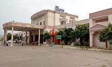
There are good number of schools, degree colleges, engineering colleges and universities. These include Rajiv Gandhi Institute of Medical Sciences, Kandula Srinivasa Reddy Memorial College of Engineering, Hyderabad Public School.
Transport
Roadways
Kadapa has good road connectivity. NH-40 passes through the city and connects it with Kurnool and Chittoor.[25] APSRTC provides bus services to various destinations of the Kadapa district and other cities of the state like Hyderabad, Vijayawada, Vishakhapatnam, Rajahmundry, Vellore, Tirupati, and also the capitals of the neighbouring states Bangalore and Chennai. The city has a total road length of 803.84 km.[26]
Railways
Kadapa has its own railway station in the city. The Mumbai-Chennai line which happens to be one of the busiest lines in the south central region passes through Kadapa railway station. It is one of the A category railway station in south central railway under Guntakal railway division.
Airways
Cuddapah Airport was opened for air traffic on 7 June 2015.[27] It is located at a distance of 12 km north west of the City.
See also
References
- ↑ "New Commissioners for Guntur, Kadapa". The Hindu. Hyderabad. 13 August 2015. Retrieved 13 August 2015.
- ↑ "Kadapa Municipal Corporation at a Glance" (PDF). Kadapa Municipal Corporation. Retrieved 12 February 2016.
- ↑ "Andhra Pradesh (India): Districts, Cities, Towns and Outgrowth Wards - Population Statistics in Maps and Charts". citypopulation.de.
- ↑ "Andhra Pradesh (India): State, Major Agglomerations & Cities - Population Statistics in Maps and Charts". citypopulation.de.
- ↑ "India Post- PIN Code Search". http://www.indiapost.gov.in/. Department of Posts, Ministry of Communications & Information Technology, Government of India. Retrieved 8 October 2013. External link in
|work=(help) - ↑ "STD Codes (Andhra Pradesh)". Sarkaritel. 2005. Retrieved 19 October 2009.
- ↑ "It will be `Kadapa' henceforth". The Hindu. 18 August 2005. Retrieved 8 October 2013.
- ↑ "Kadapa Municipal Corporation About Kadapa". Kadapa Municipal Corporation. Retrieved 28 February 2016.
- ↑ "History of Kadapa". kadapaonline.in.
- ↑ "Brief about Kadapa Municipal Corporation". Municipal Administration & Urban Development Department, Govt. of Andhra Pradesh. Retrieved 27 November 2012.
- ↑ "redirect to /world/IN/02/Cuddapah.html". fallingrain.com.
- ↑ "Geography of Cuddapah, Climate of Cuddapah, Rivers in Kadapa". kadapaonline.in.
- ↑ Hussain. "Kadapa City". kadapacityrayalseema.blogspot.com.
- ↑ "KADAPA Weather, Temperature, Best Season, Kadapa Weather Forecast, Climate". mustseeindia.com.
- ↑ "Climate: kadapa". Retrieved 19 February 2016.
- ↑ "Census of India – Socio-cultural aspects". Government of India, Ministry of Home Affairs. Retrieved 2 March 2011.
- ↑ http://theglobaljournals.com/paripex/file.php?val=November_2012_1353430588_c1e2b_21.pdf
- ↑ "Urban Agglomerations/Cities having population 1 lakh and above" (PDF). Provisional Population Totals, Census of India 2011. Retrieved 20 October 2012.
- ↑ "Cities having population 1 lakh and above" (PDF). Provisional Population Totals, Census of India 2011. Retrieved 20 October 2012.
- ↑ ":: KADAPA MUNICIPAL CORPORATION". ap.gov.in.
- ↑ "Y.S.R.-District Panchayat". appr.gov.in.
- ↑ "Cuisine of Kadapa". kadapaonline.in.
- ↑ "School Eduvation Department" (PDF). School Education Department, Government of Andhra Pradesh. Retrieved 7 November 2016.
- ↑ "The Department of School Education - Official AP State Government Portal | AP State Portal". www.ap.gov.in. Retrieved 7 November 2016.
- ↑ "NH wise Details of NH in respect of Stretches entrusted to NHAI" (PDF). National Highways Authority of India (NHAI). Retrieved 4 July 2008.
- ↑ "DETAILS OF ROADS IN EACH ULB OF ANDHRA PRADESH".
- ↑ "Transport in Kadapa". kadapaonline.in.
External links
| Wikimedia Commons has media related to Kadapa. |
![]() This article incorporates text from a publication now in the public domain: Chisholm, Hugh, ed. (1911). "article name needed". Encyclopædia Britannica (11th ed.). Cambridge University Press.
This article incorporates text from a publication now in the public domain: Chisholm, Hugh, ed. (1911). "article name needed". Encyclopædia Britannica (11th ed.). Cambridge University Press.
 |
Guntakal, Bellary | Kurnool, Hyderabad | Guntur, Vijayawada | |
| Anantapur, Davanagere | |
Nellore | ||
| ||||
| | ||||
| Hindupur, Banglore | Rayachoti, Chittoor | Rajampet, Tirupati, Chennai |
| Topics |  | |
|---|---|---|
| Regions | ||
| Districts | ||
| Million-plus cities | ||
| Cities (population over 1 lakh) | ||
| Tourism |
| |
| Related lists |
| |
| ||