Ka'ala
| Kaʻala | |
|---|---|
 Plateau at the summit of Mount Kaʻala | |
| Highest point | |
| Elevation | 4,025 ft (1,227 m) [1] |
| Prominence | 4,025 ft (1,227 m) |
| Coordinates | 21°30′25″N 158°08′34″W / 21.50694°N 158.14278°WCoordinates: 21°30′25″N 158°08′34″W / 21.50694°N 158.14278°W [2] |
| Naming | |
| Pronunciation | Hawaiian pronunciation: [kəˈʔɐlə] |
| Geography | |
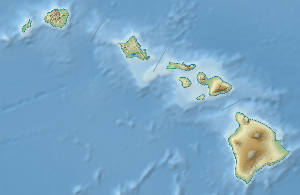 Kaʻala Hawaiian Islands | |
| Location | Oahu, Hawaii, US |
| Parent range | Waianae Range |
| Topo map | USGS Haleiwa |
| Geology | |
| Age of rock | 3.9 Ma |
| Mountain type | Plateau |
| Volcanic arc/belt | Hawaiian-Emperor seamount chain |
.jpg)
Hāpuʻu ʻiʻi, Hawaiian tree fern (Cibotium menziesii) at Mount Kaʻala, Oʻahu. It is endemic to the Hawaiian Islands and the uncoiled fronds (fiddles) are eaten boiled. The starchy core of the ferns was considered a famine food or used as pig feed. It was prepared by peeling the young fronds or placing the entire trunk with the starchy center in an ʻimu or volcanic steam vents. A saying was "He hāpuʻu ka ʻai he ai make" (If the hāpuʻu is the food, it is the food of death)
Kaʻala or Mount Kaʻala or (pronounced [kəˈʔɐlə] in Hawaiian) is the highest mountain on the island of Oahu, at 4,025 feet (1,227 m). It is a part of the Waianae Range, an eroded shield volcano which is located on the west side of the island. The FAA maintains an active tracking station at the summit, which is closed to the general public and secured by the US Army which is stationed just on the base of the mountain, at Schofield Barracks. The tracking station can be clearly seen from afar as a white domed shaped structure.
See also
- List of mountain peaks of the United States
- Evolution of Hawaiian volcanoes
- Hawaii hotspot
- Hawaiian–Emperor seamount chain
References
- ↑ "Mt. Mount Ka'ala". Department of Forestry and Wildlife. State of Hawaii. Retrieved 2013-02-21.
- ↑ "Ka'ala". Geographic Names Information System. United States Geological Survey. Retrieved 2009-12-23.
External links
Honolulu (capital) | ||
| Topics | ||
| Society | ||
| Main Islands | ||
| Northwestern Islands | ||
| Communities | ||
| Counties | ||
| Sovereignty Movement | ||
Hawaiian volcanism topics (list) | ||
|---|---|---|
| Windward Isles |  | |
| Leeward Isles | ||
| Emperor Seamounts | ||
| Topics | ||
This article is issued from Wikipedia - version of the 10/24/2016. The text is available under the Creative Commons Attribution/Share Alike but additional terms may apply for the media files.